LIP1 – Land north of Haslemere Road, Liphook LAA Reference Site Size (Ha) Existing Use Proposed Future Use Proposed Number of Homes
LIP-005 2.5 ha Agriculture Housing 24
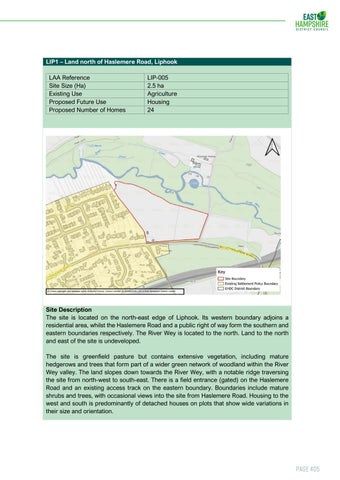
Site Description The site is located on the north-east edge of Liphook. Its western boundary adjoins a residential area, whilst the Haslemere Road and a public right of way form the southern and eastern boundaries respectively. The River Wey is located to the north. Land to the north and east of the site is undeveloped. The site is greenfield pasture but contains extensive vegetation, including mature hedgerows and trees that form part of a wider green network of woodland within the River Wey valley. The land slopes down towards the River Wey, with a notable ridge traversing the site from north-west to south-east. There is a field entrance (gated) on the Haslemere Road and an existing access track on the eastern boundary. Boundaries include mature shrubs and trees, with occasional views into the site from Haslemere Road. Housing to the west and south is predominantly of detached houses on plots that show wide variations in their size and orientation.
Page 405