Part d - Chapter twelve - site allocations
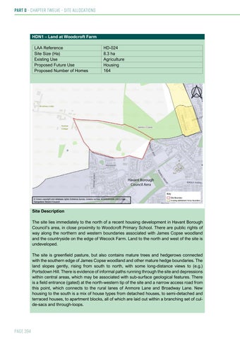
HDN1 – Land at Woodcroft Farm LAA Reference Site Size (Ha) Existing Use Proposed Future Use Proposed Number of Homes
HD-024 8.3 ha Agriculture Housing 164
Site Description The site lies immediately to the north of a recent housing development in Havant Borough Council’s area, in close proximity to Woodcroft Primary School. There are public rights of way along the northern and western boundaries associated with James Copse woodland and the countryside on the edge of Wecock Farm. Land to the north and west of the site is undeveloped. The site is greenfield pasture, but also contains mature trees and hedgerows connected with the southern edge of James Copse woodland and other mature hedge boundaries. The land slopes gently, rising from south to north, with some long-distance views to (e.g.) Portsdown Hill. There is evidence of informal paths running through the site and depressions within central areas, which may be associated with sub-surface geological features. There is a field entrance (gated) at the north-western tip of the site and a narrow access road from this point, which connects to the rural lanes of Anmore Lane and Broadway Lane. New housing to the south is a mix of house types from detached houses, to semi-detached and terraced houses, to apartment blocks, all of which are laid out within a branching set of culde-sacs and through-loops.
Page 394