Part d - Chapter twelve - site allocations
CTN1 – Land at Parsonage Farm LAA Reference Site Size (Ha) Existing Use Proposed Future Use Proposed Number of Homes
HD-002 0.7 ha Natural greenspace and derelict structures Housing 6
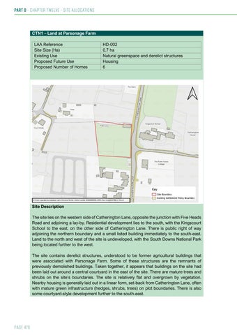
Site Description The site lies on the western side of Catherington Lane, opposite the junction with Five Heads Road and adjoining a lay-by. Residential development lies to the south, with the Kingscourt School to the east, on the other side of Catherington Lane. There is public right of way adjoining the northern boundary and a small listed building immediately to the south-east. Land to the north and west of the site is undeveloped, with the South Downs National Park being located further to the west. The site contains derelict structures, understood to be former agricultural buildings that were associated with Parsonage Farm. Some of these structures are the remnants of previously demolished buildings. Taken together, it appears that buildings on the site had been laid out around a central courtyard in the east of the site. There are mature trees and shrubs on the site’s boundaries. The site is relatively flat and overgrown by vegetation. Nearby housing is generally laid out in a linear form, set-back from Catherington Lane, often with mature green infrastructure (hedges, shrubs, trees) on plot boundaries. There is also some courtyard-style development further to the south-east.
Page 476