CFD2 – Land at Drift Road LAA Reference Site Size (Ha) Existing Use Proposed Future Use Proposed Number of Homes
HD-010 (part) 6.0 ha Agriculture Housing 80
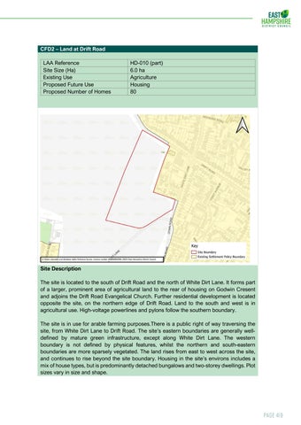
Site Description The site is located to the south of Drift Road and the north of White Dirt Lane. It forms part of a larger, prominent area of agricultural land to the rear of housing on Godwin Cresent and adjoins the Drift Road Evangelical Church. Further residential development is located opposite the site, on the northern edge of Drift Road. Land to the south and west is in agricultural use. High-voltage powerlines and pylons follow the southern boundary. The site is in use for arable farming purposes.There is a public right of way traversing the site, from White Dirt Lane to Drift Road. The site’s eastern boundaries are generally welldefined by mature green infrastructure, except along White Dirt Lane. The western boundary is not defined by physical features, whilst the northern and south-eastern boundaries are more sparsely vegetated. The land rises from east to west across the site, and continues to rise beyond the site boundary. Housing in the site’s environs includes a mix of house types, but is predominantly detached bungalows and two-storey dwellings. Plot sizes vary in size and shape.
Page 419