Part d - Chapter twelve - site allocations
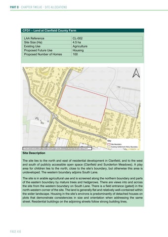
CFD1 – Land at Clanfield County Farm LAA Reference Site Size (Ha) Existing Use Proposed Future Use Proposed Number of Homes
CL-002 4.5 ha Agriculture Housing 100
Site Description The site lies to the north and east of residential development in Clanfield, and to the west and south of publicly accessible open space (Clanfield and Sunderton Meadows). A play area for children lies to the north, close to the site’s boundary, but otherwise this area is undeveloped. The western boundary adjoins South Lane. The site is in arable agricultural use and is screened along the northern boundary and parts of the eastern boundary by mature trees and hedgerows. There are views into and across the site from the western boundary on South Lane. There is a field entrance (gated) in the north-western corner of the site. The land is generally flat and relatively well-contained within the wider landscape. Housing in the site’s environs is predominantly of detached houses on plots that demonstrate consistencies in size and orientation when addressing the same street. Residential buildings on the adjoining streets follow strong building lines.
Page 416