BWH2 – Land at the corner of Church Street LAA Reference Site Size (Ha) Existing Use Proposed Future Use Proposed Number of Homes
BTW-002 1.3 ha Agricultural Housing 5
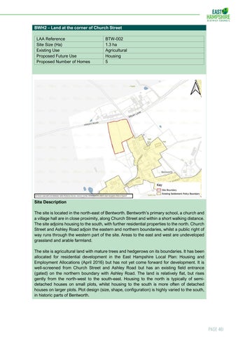
Site Description The site is located in the north-east of Bentworth. Bentworth’s primary school, a church and a village hall are in close proximity, along Church Street and within a short walking distance. The site adjoins housing to the south, with further residential properties to the north. Church Street and Ashley Road adjoin the eastern and northern boundaries, whilst a public right of way runs through the western part of the site. Areas to the east and west are undeveloped grassland and arable farmland. The site is agricultural land with mature trees and hedgerows on its boundaries. It has been allocated for residential development in the East Hampshire Local Plan: Housing and Employment Allocations (April 2016) but has not yet come forward for development. It is well-screened from Church Street and Ashley Road but has an existing field entrance (gated) on the northern boundary with Ashley Road. The land is relatively flat, but rises gently from the north-west to the south-east. Housing to the north is typically of semidetached houses on small plots, whilst housing to the south is more often of detached houses on larger plots. Plot design (size, shape, configuration) is highly varied to the south, in historic parts of Bentworth.
Page 461