The Green Infrastructure Spatial Framework

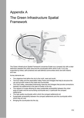
The Green Infrastructure Spatial Framework conceives Exeter as a compact city with a clear distinction between the urban area and the countryside within which it sits. It is a city supported by linked, self-contained and well-defined communities which are both historic and new.
Its key elements are:
• The ridgelines that define the city to the north, west and south;
• The Exe Valley and the associated Valley Parks and linkages that help to structure the city and provide routes to the coast and countryside;
• The Clyst Valley, associated biodiversity reserves and linkages that provide connections between the settlements to the east of Exeter to the city;
• The network of routes allowing for easy sustainable accessibility between the urban area of Exeter and the surrounding countryside and, in particular the compact settlements;
• The high quality countryside within which the compact settlements sit;
• Sustainable accessibility between the compact settlements and the countryside within which they sit; and
• Bringing the countryside into the city