4. Strategic Policies and Development Principles
4.1. This part of the Local Plan sets out the spatial strategy and how future development in the National Park will be managed over the plan period. At the heart of the Local Plan is the delivery of sustainable development and responding to the climate and nature emergencies in so far as they relate to planning. Accordingly, all of the strategic objectives apply, as do the Park’s special qualities and links to the themes identified in the Partnership Plan.
Supporting sustainable development
4.2. The NPPF states that local plans should contribute to the achievement of sustainable development It sets out a presumption in favour of sustainable development, which should run through both plan-making and decision-taking. In addition, the National Parks Circular (2010) states that the national park authorities’ primary responsibility is to deliver their statutory purposes and duties with a focus on economic and social well-being. More recently the Levelling Up and Regeneration Act has the strengthened the protected landscapes5 duty. This requires relevant authorities to ‘seek to further’ the statutory purposes of Protected Landscapes and in doing so, this reinforces National Parks being exemplars in achieving sustainable development.
4.3. There are three dimensions to sustainability:
• a social role – supporting strong, vibrant and healthy communities, through the supply of housing, accessible local services and by creating a high-quality built and natural environment;
• an environmental role – protection and enhancement of the natural, built and historic environments, adapting to climate change, and making efficient use of natural resources while minimising waste and preventing pollution; and
• an economic role – contributing to a strong, responsive and competitive economy, by supporting local businesses and land managers.
4.4. Policy SP1 takes a positive approach to sustainable development in accordance with the NPPF, recognising the protection afforded to national parks in national planning policy and having full regard to the statutory National Park purposes and related duties.
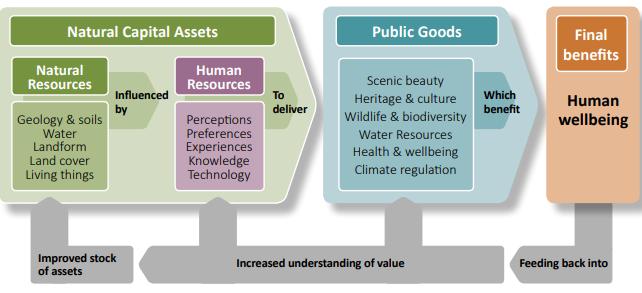
4.5. There is also increasing recognition of the wider sustainability benefits that national parks offer to society, through their inherent natural capital (natural assets). These benefits are commonly referred to as ‘ecosystem services’ and cover the services provided by the landscape and habitats of national parks. A report was produced in 2019 which assessed the New Forest’s valuable natural
5 As amended by Section 245 (Protected Landscapes) of the Levelling-up and Regeneration Act 2023
assets or ‘natural capital’, such as rivers, soils and woodland, and how these can be managed to benefit society. The public goods provided by the New Forest were identified as:
Source: NFNPA Natural Capital Report (2019)
4.6. The report concluded that the extent and condition of most natural capital assets in the New Forest was good and either static or improving Key reasons related to the support for commoning, promoting both quality and quantity of grazing livestock, the restoration of commercial forestry enclosures to grazed heath and improvement to watercourses to a more naturally functioning state. Factors responsible for declining extent or condition include the changing climate, intrusion and disturbance from human activities and economic pressures.
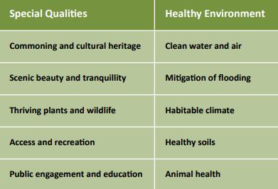
4.7. A key element of natural capital is providing benefits to people’s health and wellbeing (Natural Health Service) through their enjoyment of the National Parks’ special qualities:
Source: NFNPA Natural Capital Report (2019)
4.8. Consequently, there is a key role for the Local Plan Review to influence where it can those matters that affect the natural capital to ensure its inherent elements continue to prosper, as expressed in Policy SP1.
Policy SP1: Supporting sustainable development
The National Park Authority will support sustainable development proposals that allow its natural and cultural heritage capital to prosper through:
• conserving and enhancing the natural beauty, wildlife and cultural heritage of the National Park and its special qualities; and
• promoting opportunities for their understanding and enjoyment by the public, and when doing so, will foster the social and economic well-being of local communities.
Where there is an irreconcilable conflict between the statutory purposes, greater weight will be attached to the conservation and enhancement of the National Park (in line with Section 62(2) of the Environment Act 19956).
Sustainable development in the National Park is considered to be that which:
a) makes the National Park a high-quality place to live, work and visit –including appropriate new housing to address local needs; access to local employment opportunities; improved public transport and active travel links; local infrastructure provision including digital connectivity; and enhanced community and recreational facilities;
b) either maintains or has a positive impact on the ability of the natural assets (capital) of the National Park to contribute to society through the provision of food and water, regulation of floods, prevention of soil erosion or compaction, and disease outbreaks, opportunities to improve health and well-being through informal recreation and access to open space;
c) enhances and protects the unique landscape of the New Forest through high quality design and responding to the local distinctiveness of the area;
d) contributes positively to the built and historic environment of the New Forest;
e) does not impact on the integrity of the protected habitats of the New Forest, including its coastline and includes proposals to mitigate against any negative impacts and provide for habitat improvement;
f) is resilient and positively responds to the impacts of climate change through mitigation and adaptation, improved energy efficiency and making appropriate use of small-scale renewable energy; and
g) maximises the use of sustainable construction and demolition practices that prioritise the reuse of waste in line with the Waste Hierarchy, favours
6 The relationship between the two Park purposes is commonly referred to as the Sandford Principle. Every effort should be made to reconcile any conflict between the two purposes, but if such efforts fail, the first purpose takes precedence.
local materials, minimises energy use, and incorporates nature-based solutions such as sustainable drainage systems (SuDS).
4.9. This approach is consistent with the NPPF which sets out a presumption in favour of sustainable development and indicates where development should be restricted, including sites protected under the Habitats Directive, Sites of Special Scientific Interest (SSSI) and land within a national park.
4.10. National policy is clear that objectively assessed needs should be met unless “any adverse impacts of doing so would significantly and demonstrably outweigh the benefits, when assessed against the policies in the Framework taken as a whole” (NPPF para 11b.ii).
4.11. The Authority will encourage and support the use of natural sustainable materials in the design of new development and for these to be sourced locally. This also benefits the local economy and supports land managers in the Park.
4.12. The Waste Hierarchy establishes the preferred order of waste management actions based on their environmental impact and is embedded within national legislation and planning policy requirements. The hierarchy places prevention as the most desirable option, aimed at avoiding the creation of waste. This is followed by reuse, which promotes the continued use of products and materials. Recycling enables waste materials to be processed into new products, while recovery encompasses the extraction of value – such as energy – from residual waste. The principles of prevention, reuse, recycling, and resource recovery underpin a circular economy approach and should guide sustainable development proposals.
4.13. In line with the requirements of national policy, Policy SP1 sets out the overarching approach to the delivery of sustainable development within the context of a nationally protected landscape. This strategic policy is supported by a number of more detailed policies throughout the Local Plan on specific aspects and the following general development principles that the Authority expects all development within the National Park to be considered against.
Policy DP2: General development principles
All new development and uses of land within the New Forest National Park must uphold and promote the principles of sustainable development.
New development proposals should reflect the New Forest National Park Design Code (set out in Annex 2) and the National Model Design Code in so far as it applies to the landscape and setting of a National Park and demonstrate high quality design and sustainable construction which enhances local character and distinctiveness
Development proposals will be permitted where they can demonstrate how the development will work positively to increase biodiversity and ecosystem integrity, sustaining the ability of the natural environment to contribute goods and services. Proposals should also demonstrate a positive impact on the socio-economic well-being of local communities where appropriate
This includes, but is not restricted to, development that:
a) is appropriate and sympathetic in terms of scale, massing, appearance, form, siting and layout, and promotes well designed and safe, inclusive, and easily navigable places;
b) incorporates current best practice in energy conservation; such measures should be integral to the layout and building design and minimise impact on the site and its surroundings;
c) demonstrates how development would reflect mitigation and adaptation to climate change, including how flood resistance and resilience is incorporated into building design;
d) respects the natural, built and historic environment, landscape character and sustains biodiversity;
e) includes opportunities to protect and enhance the setting of groups and individual trees, hedges and hedgerows and to include new planting of native trees and hedges where appropriate;
f) incorporates materials and boundary treatments that are appropriate to the site and its setting;
g) would not result in unacceptable adverse impacts on amenity in terms of additional impacts, visual intrusion, overlooking, shading, or unreasonable loss of privacy;
h) would not result in unacceptable adverse impacts associated with traffic or pollution (including air, soil, water, noise and light pollution) and there is an appropriate access which respects the New Forest’s status as a nationally protected landscape;
i) maximises opportunities to reduce the need to travel and enable active travel;
j) reflects the principles of Building for a Healthy Life and the Healthy Streets Approach;
k) where appropriate, enhances public health taking a holistic approach, incorporating best practice.
New development must also comply with required standards for:
l) car and cycle parking (see Annex 3);
m) open space (as set out in Policy DP16);
n) sustainable drainage (national standards).
4.14. High-quality design, as defined by the NPPF and National Design Guide, is development that is sustainable, functional and responsive to its context – not simply aesthetic. It should create durable places that strengthen local character and support community well-being. Key principles include using sustainably sourced high-quality materials, incorporating effective landscaping, and providing a strong sense of place that functions well throughout its lifetime.
4.15. Development should actively promote health and well-being through a holistic approach that encourages physical activity, social interaction, and mental resilience to promote safe and healthy communities, in line with the NPPF. Proposals should improve access to green space, support inclusive and public realms, and integrate design measures that reduce health inequalities, including those affecting rural areas and those exacerbated by climate change. These principles are enshrined in the Building for a Healthy Life7 and Healthy Streets Approach which are summarised in the table below
Building for a Healthy Life
Integrated Neighbourhoods
Natural connections
Walking, cycling and public transport
Facilities and services
Homes for everyone
Distinctive Places
Making the most of what’s there
Memorable character
Well defined streets and spaces
Easy to find your way around
Streets for All
Healthy streets
Cycle and car parking
Green and blue infrastructure
Back of pavement, front of home
Spatial strategy
Healthy Streets
Everyone feels welcome
Easy to cross
Shade and shelter
Places to stop and rest
Not too noisy
People choose to walk and cycle
People feel safe
Things to see and do
People feel relaxed
Clean air
4.16. Planning in the New Forest National Park is underpinned by the delivery of the two statutory Park purposes and the related socio-economic duty. These purposes and duty apply across the whole of the designated National Park. The focus of new development will be on small-scale proposals that reflect the area’s character and address the needs of local communities in the National Park, rather than catering for external demand.
4.17. The New Forest is a rural area with small, dispersed settlements that generally have a limited range of facilities. None of the villages within the National Park have populations greater than 3,500 people and higher order services are normally provided in the larger towns and urban areas that fringe the National Park. The Local Plan sets out where new development will take place in line with the principles of sustainable development and the statutory framework of the National Park purposes
7 Building for a Healthy Life, Homes England (2020)
4.18. National policy confirms that planning should actively manage patterns of growth to make the fullest possible use of public transport, walking and cycling, and concentrate significant development in locations which are or can be made sustainable. Sustainable development in rural areas should be promoted by focusing development where it will enhance or maintain the vitality of rural communities and sustain the settlements over the long term, by supporting local services
4.19. This Local Plan has provided the opportunity to revise the spatial strategy and how new development is distributed across the National Park. Establishing a settlement hierarchy is a recognised tool to distinguish between settlements in terms of their size, employment opportunities, transport links and range of services and facilities At the top of the hierarchy will be settlements that fulfil the most functions and are the most sustainable. Below this will be settlements that offer a smaller range of services and facilities Smaller, less sustainable, settlements with fewer services and facilities will be towards the bottom of the hierarchy.
4.20. Given the range of villages within the New Forest, the villages of Ashurst, Brockenhurst, Lyndhurst and Sway (Larger Defined Villages) have in the past provided a focus for new development and currently these villages provide homes for around one third of all National Park residents.
4.21. In line with national policy, future development in the National Park is likely to be modest, but it will be important to ensure that the main villages continue to prosper. Consequently, a review of the settlement hierarchy has concluded there are other ‘Smaller Defined Villages’ which offer a basic range of facilities and services and could offer opportunities for sustainable development, these being CadnamBartley, Landford - Nomansland and Redlynch.
4.22. Consequently, together these ‘Larger Defined Villages’ and ‘Smaller Defined Villages’ are considered to be the most sustainable settlements in the National Park as they have the broadest range of community facilities, local employment opportunities, transport links and a good range of other services for residents and visitors. The strategic approach for these villages seeks to:
• sustain and enhance the local services and facilities in the villages;
• support the important role of the villages in the local tourism economy;
• support the provision of appropriate housing, employment, retail and community facilities; and
• conserve the distinctive character and heritage of the villages.
4.23. The remaining settlements in the National Park are significantly smaller and have a more limited range of services, facilities and transportaccessibility. The relatively small and scattered nature of these rural settlements means that the level of development will be more limited, but it is important that local communities across the National Park continue to thrive. The Spatial Strategy therefore supports the provision of affordable housing for local people in and adjoining these smaller settlements through the rural exception policy to help to address local housing needs. It also enables the delivery of housing specifically for New Forest Commoners, Estate Workers, and dwellings tied to the rural economy. In addition,
the Local Plan supports the provision of employment opportunities and essential local community facilities to support the sustainability of local communities.
4.24. A matter not to be overlooked is the proximity of the National Park to surrounding urban areas which provide a range of services, including but not limited to Downton, Fordingbridge, Ringwood, New Milton, Lymington, Hythe and Dibden, Totton and Eling and Romsey.
4.25. The spatial strategy recognises the importance of positively managing recreation and visitor activity across the National Park. This includes enhancing access and recreation provision in the most appropriate locations, increasing opportunities for walking, wheeling, cycling and other sustainable forms of travel, and ensuring that the Park’s most sensitive habitats and landscapes are protected. By planning where recreation takes place, the strategy seeks to balance the enjoyment of the National Park with the conservation of its special qualities.
4.26. The evidence base8 for the New Forest National Park Local Plan indicates a housing need of circa 260 dwellings per annum. This figure is the starting point for the plan-making process. It is a ‘policy off’ assessment of need that does not factor in the range of nationally and internationally important landscape and nature conservation designations in the New Forest National Park. Consequently, considering the environmental designations and revised settlement hierarchy, the Local Plan makes provision for around 950 homes over the plan period to 2043 –equivalent to about 50 per annum – taking into account existing commitments and completions since April 2024. This scale of development will stabilise the population of the National Park and help support local services within the Park.
4.27. Employment evidence9 also suggests that the strategy for the Local Plan should be to retain existing employment provision and allow modest expansions and/or intensification where appropriate. There is also a need for an increase in employment floorspace, as evidenced by the Economic Needs Assessment. The total amount required over the plan period is in the region of 13,500 square metres and whilst some will be delivered through small-scale redevelopment and intensification schemes, the Local Plan also allocates part of the Solent Freeport site within the National Park for employment purposes.
4.28. With regard to retail provision, there is no specific need requirement identified for the National Park, the focus being on retaining existing provision and having a supportive policy to ensure local retail facilities and services are retained and allowed to expand where appropriate.
4.29. The Local Plan makes provision for pitches and plots for Gypsies, Travellers and Travelling Showpeople as evidenced in the Gypsy & Traveller Accommodation Assessment10 through a site allocation and a criteria-based policy Accordingly, the spatial strategy for the plan period 2024 – 2043 is set out below and settlement boundaries have been accordingly applied. The Key Diagram that follows
8 New Forest Housing Needs Assessment, Iceni (August 2025).
9 New Forest Economic Needs Assessment, Lichfields (August 2025)
10 New Forest National Park Authority Gypsy and Traveller Accommodation Assessment, ORS (January 2026)
19
illustrates the basic spatial strategy in the New Forest National Park.
Policy SP3 Spatial Strategy
The focus for new development within the New Forest National Park will be within the Defined Villages with settlement boundaries, as shown on the Policies Map and listed below:
Larger Defined Villages
• Ashurst
• Brockenhurst
• Lyndhurst
• Sway
Smaller Defined Villages
• Cadnam - Bartley
• Landford - Nomansland
• Redlynch
Over the plan period 2024 – 2043, the Local Plan will make provision for the delivery of around 950 homes, equivalent to about 50 per annum.
Employment needs will be met through the strategic allocation of Land North of Fawley Waterside for around 12,000 square metres of new mixed employment provision, in accordance with Policy SP5. In addition, smaller scale redevelopment and expansion opportunities for employment purposes will be supported within settlement boundaries where appropriate. Retail needs will be met within the existing defined shopping frontages and by the retention of existing local services and facilities.
Provision will be made for Gypsy & Traveller provision through a criteria-based policy; and 6 plots for Travelling Showpeople through a site allocation at policy SP50. The National Park Authority will make provision for additional pitches and plots by permitting suitable sites.
Development proposals on previously developed land will be supported where these comply with other relevant policies and are of a scale and nature appropriate to the character and function of the site.
In settlements without defined settlement boundaries, development proposals will only be permitted where:
a) it is in accordance with Policy SP43 on Rural Exception Sites; or
b) it is in accordance with Policy DP56 on employment sites; or
c) there is an essential need for a countryside location, or
d) it meets the specific locational needs for Commoners, Estate Workers or agricultural dwellings; or
e) it is an appropriate reuse or redevelopment of an existing building(s) in accordance with Policy DP59
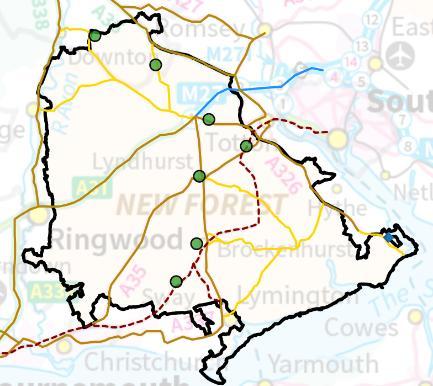
Key Diagram
(Defined Villages shown by the green dot; employment allocation by blue diamond)

Major development in the New Forest National Park
4.30. National planning policy dating back many decades has contained a clear presumption against major new development in national parks because of the harm it would cause to the long-term national interest in conserving these landscapes. Major development is therefore only permitted within protected landscapes in exceptional circumstances and where it can be demonstrated that it is in the public interest, as outlined in the NPPF.
4.31. The NPPG states that it will be a matter for the relevant decision taker as to whether a proposed development within the National Park should be treated as major development, taking into account the proposal in question and the local context. For the purposes of Policy SP4, the term ‘major development’ will not be restricted to the definition of major development in the Town & Country Planning (Development Management Procedure) (England) Order 2015 or to proposals that raise issues of national significance.
4.32. Major development is development of more than local significance (i.e. it would exceed the local scale of development needed to address the socio-economic needs of the New Forest’s 35,000 residents) and which would have a long-term impact on the landscape, wildlife or cultural heritage of the National Park because of its scale and form. This can include major residential and commercial development (including tourism), significant infrastructure projects and power generation, including renewable energy
4.33. All forms of major development can have a significant impact on the special qualities of the New Forest and the reasons why the National Park was designated – relating to its outstanding natural beauty; the variety of landscapes and habitats, and the opportunities provided for the public to enjoy the Forest.
Policy SP4: Major development in the National Park
In the context of the New Forest National Park, major development is defined as development which has the potential to have a significant impact on the National Park and its special qualities due to its scale, character and nature.
Planning permission will only be granted for major development within the New Forest National Park in exceptional circumstances and where it can be demonstrated to be in the public interest.
Consideration of such applications should include an assessment of:
a) the need for the development, including in terms of any national considerations, and the impact of permitting it, or refusing it, upon the local economy;
b) the cost of, and scope for, developing outside the New Forest National Park, or meeting the need for it in some other way;
c) any detrimental effect on the environment, the landscape and quiet recreational opportunities and the extent to which that could be moderated and mitigated;
d) any detrimental impact on the special qualities of the New Forest National Park in particular its tranquillity, and whether these can be mitigated; and
e) the cumulative impact of the development when viewed with other proposals.
Solent Freeport
4.34. The Solent Freeport was designated by Government in December 2022 and is one of 12 Freeports across the UK, and the only Freeport that includes land within a National Park in England. Freeports are new hubs for global trade, investment, and innovation within the UK that create a favourable environment and exciting opportunities for businesses to grow. Investment within a UK Freeport, enables access to a wide range of customs and tax benefits, as well as support from government around planning, infrastructure and innovation.
4.35. The Solent Freeport stretches across several sites (both tax and custom sites), located in and around Portsmouth and Southampton, making it one of the UK’s most important gateways to European and global markets, with a population exceeding 1.25 million and over 42,000 businesses operating in the area.
4.36. Land at Fawley Waterside, is one of seven ‘tax sites’, covers 70 acres of land. The site has a dedicated dock and there is to a focus on marine innovation, port-centric manufacturing and energy sectors The site lies partially within the National Park, with the commercial opportunity spread over 360,000 square metres on the site of the former Fawley Power station and adjacent land
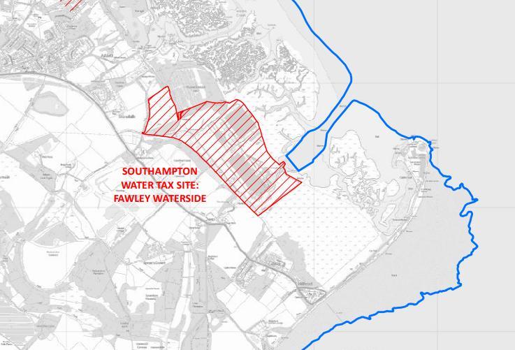
Source: Map of Solent Freeport, UK Government Publishing Service.
4.37. The Economic Needs Assessment commissioned to inform the Local Plan identified a need for an extra 13,500 square metres of employment land over the plan period, primarily for industrial/mixed employment purposes. Given the limited opportunities across the National Park to meet this quantum of growth through existing routes of redevelopment and extension/intensification on existing sites, the Plan allocates the land north of Fawley Waterside, which falls within the Southampton Water Freeport tax site, for employment purposes. Being a Freeport Tax site, the site will also benefit from a range of tax incentives such as enhanced capital allowances and relief from employer National Insurance contributions for new employees and relief on Stamp Duty Land Tax The previously agreed fiveyear tax benefits window was extended in the summer of 2024 to 10 years, until September 2031, delivering a boost for businesses investing and hiring new employees in, or connected with, Solent Freeport to stimulate investment and provide greater certainty to investors to maximise the programme’s impact.
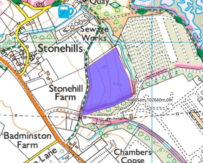
4.38. The part of the Solent Freeport site which falls within the National Park equates to about 7 hectares of land. This lies to the north-west of the Fawley Power Station site, with Ashlett Creek Wastewater Treatment plant to the north. It is accessed off a private road, reached via the Northern Access Road. A public footpath (Fawley Footpath 1) runs alongside the site, parallel to the west of the private road.
The site is set back from public view and fully screened except to the north-east, from where the site can be viewed from Southampton Water. There is a watercourse running along the eastern boundary of the site. The site is relatively unconstrained, being beyond any of the international nature conservation designations which cover extensive parts of the New Forest, although it lies within the 5.6km buffer zone of the Solent and Southampton Water Special Protection Area (which relates to in-combination recreational impacts). It also lies beyond areas in the vicinity that fall within Flood Zones 2 and 3. The site is, however, located within the Aerodrome Safeguarding Consultation Zone for Southampton Airport, potentially limiting the height of new buildings and structures.
4.39. The site has been in recorded use since the 1940s, initially as a Ministry of Defence fuel storage facility which was decommissioned and largely dismantled during the 1960s. It has subsequently operated as a waste recycling and transfer facility. More recently, the site has been subject to unauthorised importation and deposition of household waste beyond the scope of the permitted waste recovery and transfer activities. Despite limited historic remediation, waste remains both above and below ground, presenting potential risks to soils and groundwater.
4.40. Remediation is therefore required to remove stockpiled and illegally deposited materials and to address suspected contamination associated with residual underground structures. Remediation is anticipated to be undertaken in two phases, addressing superficial waste first and then below-ground contamination. While remediation costs represent an abnormal development cost, contamination is not considered to be an overriding constraint to redevelopment, subject to appropriate remediation measures.
4.41. The site presents an opportunity to achieve sustainable new employment situated on land previously developed, in pursuance of the National Park Authority’s socioeconomic duty and in accordance with other policies in the Local Plan, and the principles to be taken into consideration given the locality of the site within the National Park.
Policy SP5: Land to north of Fawley Waterside
Land to north of Fawley Waterside, as designated on the Policies Map, is allocated for employment and remediation purposes, in accordance with the following principles:
a) the area to be the focus for around 12,000 square metres of new mixeduse employment floorspace, predominantly in Use Class E(g) and B2, with limited B8 uses;
b) any scheme coming forward on the site shall carry out adequate transport assessment and design, with mitigations and/or contributions to address transport impacts. This shall include assessment of the need for, and provision where necessary of, enhancements to the B3059 and the Northern Access Road junctions to provide safe vehicular access to and from the development;
19
c) provision of opportunities for active travel linking the site to surrounding settlements, employment areas, and public transport networks;
d) submission of a drainage strategy to address flood risk;
e) development proposals should explore opportunities to enhance and restore the watercourse along the eastern boundary, including a buffer between the watercourse and built development to support habitat creation;
f) development delivers the comprehensive remediation of the whole site through a layout that conserves and enhances the landscape setting of the National Park, reflects its historic character and maintains an appropriate transition from the urban form and land uses to the south to the countryside edge of the New Forest National Park;
g) a masterplan for the whole site to ensure redevelopment is brought forward in a coordinated manner, comprehensive redevelopment is achieved and its impacts are fully mitigated.
The Authority will only consider proposals for further development on the site for mixed use employment uses, clean energy or digital infrastructure in addition to the quantum of development allocated above where robust evidence demonstrates:
(i) sufficient local, regional or national need; and
(ii) that the comprehensive remediation of the site would not be viable without additional development.
In all cases, the phasing of development on the site must ensure remediation is delivered alongside new development.
4.42. In addition to the Fawley Waterside site, there are other Solent Freeport tax sites designated within close proximity of the New Forest National Park:
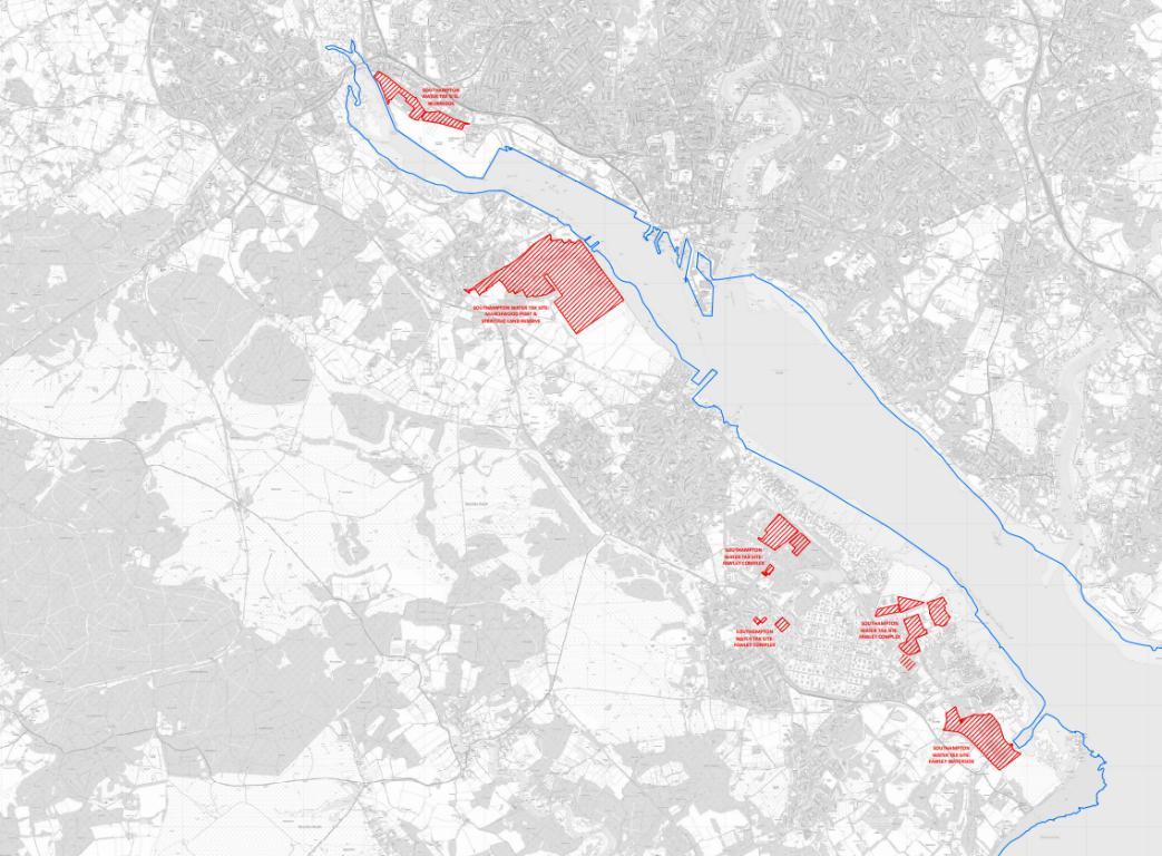
Source: Map of Solent Freeport, UK Government Publishing Service
4.43. In summary, the Solent Freeport sites close to the National Park comprise:
• ExxonMobil – ExxonMobil Fawley imports crude oil from countries all around the globe to Fawley Marine Terminal, which handles 2,000 shipping movements each year and is the longest privately owned jetty in Europe.
• Solent Gateway – Solent Gateway was formed in 2016, with a 35-year lease until 2051 to develop and operate the 83-hectare Marchwood Port on the River Test opposite the Port of Southampton. Solent Gateway is wholly owned by Associated British Ports.
• Redbridge – operated by Associated British Ports, the port is the UK’s number one hub for deep sea trade, processing 900,000 vehicles per year, with more than 100 hectares of vehicle storage and distribution compounds; the port also welcomes around two million passengers annually to its five cruise terminals. There are 12 hectares of land available offering opportunities to create bespoke facilities of up to 55,472 square metres (600,000 square feet)
• Strategic Land Reserve – 100-acre expansion of the existing Port footprint to be a global hub for EV logistics, port-centric manufacturing and green energy.
4.44. The Strategic Land Reserve site covers land previously referred to as Dibden Bay, which was identified in the Port of Southampton draft Masterplan 2016 - 2035 as the only area of land physically capable of accommodating significant expansion of the port. The site is a designated SSSI and the foreshore is designated as a Special Protection Area (SPA) and Ramsar site
4.45. Developments within these Solent Freeport Tax sites will still be required to comply with planning and environmental regulations. Depending on the scale of proposals they may qualify as a Nationally Significant Infrastructure Project (NSIP) under the 2008 Planning Act. Consequently, the Authority would be invited to submit a Local Impact Report setting out the potential impacts of the development on the adjacent National Park but would be a consultee rather than a decision maker. It would be the Planning Inspectorate who would consider and make a recommendation to the Secretary of State on whether a Development Consent Order should be issued. The Secretary of State would make the final decision
4.46. As these sites are located either within, or in close proximity to, the National Park, it is appropriate for the New Forest National Park Local Plan to set out the range of factors to be considered should the site or part of a site come forward for development. These include:
• Any future proposals within the Freeport Sites that include major development within or affecting the New Forest National Park would need to satisfy the national planning policy tests for major development affecting the National Park set out in the NPPF, the requirements of Policy SP4 Major Development in the National Park and Policy SP5 Solent Freeport.
• Section 62(2) of the Environment Act 1995 was amended by Section 245 of the Levelling Up & RegenerationAct 2023 to require all relevant bodies to seek to further the statutory National Park purposes in performing any functions in relation to, or so as to affect, land in a National Park. This includes development proposals outside the National Park that can impact on it. This is an active duty requiring the relevant body to take appropriate, reasonable and proportionate measures to explore how to further the statutory purposes, to avoid harm and contribute to the conservation and enhancement of the natural beauty, special qualities and key characteristics of the protected landscape.
• Meeting the legal requirements of the Conservation of Habitats and Species Regulations 2010 in terms of the likely effects on the internationally designated sites in the area, including the Solent and Southampton Water Ramsar Site and SPA; the Solent Maritime SAC; and the New Forest SPA and SAC.
4.47. The New Forest National Park Landscape Character Assessment (2015) identifies features, such as variations in the natural environment, settlement pattern and land uses, that give a locality it’s ‘sense of place’ and pinpoints what makes it different from neighbouring areas. This together with the Authority’s Waterside Green Links Study published in January 2024, has been informative in determining the key characteristics of those parts of the National Park area, which
would be affected by any Solent Freeport proposals11. In particular, the Waterside Green Links Study’s aim is to promote connecting green spaces within the Waterside area.
4.48. Consequently, the Authority considers that given the strengthened Protected Landscapes Duty, development proposals in the sites designated within the Solent Freeport will be required to demonstrate how they make a positive contribution to – and further – the National Park’s purposes, and should also take into consideration the following requirements to:
a) protect and strengthen the existing hedgerow network, and create new ones where appropriate, to reflect the historic small scale field patterns;
b) keep signage and lighting to a minimum;
c) protect levels of tranquillity and scenic views, using tree cover to filter longdistance views of built development;
d) reinforce the landscape’s wooded character, through management of existing areas to ensure that appropriate species thrive, employ traditional techniques such as coppicing, and replant with native species as necessary;
e) protect, retain and reinforce woodland and other areas of planting with landscape value in strategic locations to minimise views of key infrastructure such as pylons, railways and roads;
f) ensure natural buffers are retained to protect the amenity of the area;
g) maximise opportunities to enhance existing and create new multifunctional green and/or blue infrastructure links, taking into account historic landscape character; and
h) protect long distance views of landmark features, such as Calshot Castle
Infrastructure and developer contributions
4.49. New development, even on the limited scale planned in the National Park, can place extra demands on existing infrastructure. In such cases where it is not possible to make the necessary provision on site, the Authority will seek financial contributions from the developer in accordance with the framework provided by national planning policy and guidance. Within the context of the development that takes place within the National Park, developer contributions may be required towards highway and transportation works; affordable housing; education and health provision; recreation provision (including public open space enhancements); and nature conservation mitigation measures.
11 See also New Forest District Council, Landscape Value, Settlement Gaps, and Green & Blue Infrastructure in the New Forest Waterside Report (June 2024)
4.50. The existing system of securing developer contributions through Section 106 legal agreements and the Community Infrastructure Levy (CIL) is in the process of being reviewed by the Government. The National Park Authority is a charging authority under the relevant CIL Regulations and although it has not to date implemented CIL, this remains an option for the Authority in the future.
4.51. However, even if CIL (or any future national tariff system to support infrastructure provision) was implemented in the National Park there is likely to remain a role for Section 106 agreements in the future to: (i) secure necessary contributions towards infrastructure that cannot be funded through CIL (for example habitat mitigation measures that are not deemed ‘infrastructure’, such as ranger provision or an education campaign); and (ii) secure site-specific contributions from individual developments for measures that do appear on the general national parkwide infrastructure list.
4.52. Development resulting in net new dwellings or other forms of overnight accommodation will be required to contribute to the Authority's Habitat Mitigation Scheme to mitigate recreational impacts on the New Forest's internationally designated sites. Funding is split between measures delivered during the Plan period and an in-perpetuity fund to ensure long-term protection of sensitive habitats and species. Mitigation within the National Park is delivered through ranger services, visitor communication, and promotion of alternative routes to divert footfall away from vulnerable areas, along with use of the New Forest Code and Public Space Protection Orders (PSPO).
4.53. While the scheme directly relates to residential development and other forms of overnight accommodation within the National Park, extensive research into visitor behaviour has identified a 13.8km zone of influence from which most recreational visits originate, providing the basis for seeking mitigation contributions from new development. As such, the scheme is supported by cross-boundary working with neighbouring authorities and Natural England, with a Strategic Access Management and Monitoring (SAMM) framework being prepared to secure and pool contributions and deliver coordinated mitigation and monitoring of the protected sites
Policy SP6: Infrastructure provision and developer contributions
Development proposals shall make provision for the infrastructure and measures necessary to ensure that the development is acceptable in planning terms in the context of the New Forest National Park Local Plan. Where appropriate, financial contributions for the provision of off-site infrastructure and measures will be sought. Appropriate new and/or improved utility infrastructure will be permitted in order to meet the identified needs of the community.
Contributions will be secured through the appropriate mechanism – including the Community Infrastructure Levy (or any future national tariff system) and Section 106 agreements – as required by national policy.
19
In implementing this policy regard will be had to economic viability considerations at the site-specific level.