4.1 Highway Space, Road Safety and Parking
Related SPD sections • 4.2 Cycling / Active Travel
Key City Plan policies
25. Walking and Cycling
26. Public Transport and Infrastructure
27. Parking
28. Highway access management
Context
The Highways Act 1980 is a key piece of UK legislation which governs the creation, maintenance and management of public highways. It outlines the responsibilities of highway authorities (such as the City Council) in maintaining public realm and regulating activities on highways.
When preparing proposals that may impact the public realm, the Act must be considered to ensure projects align with statutory obligations. For example, under the act, certain works may require approval from the highway authority and any alterations to highways must ensure safety and accessibility of public spaces.
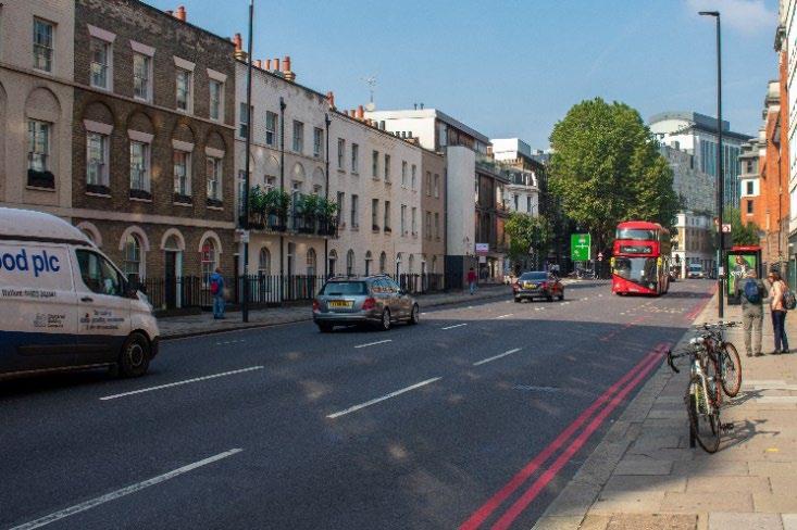
The highway is a key strategic asset. In Westminster, this comprises Transport for London’s Road Network – strategic through routes, plus Westminster’s highway network – connecting and local routes operated, and maintained by the City Council
The highway is where there is a public right of passage over land at all times ‘without let or hindrance’, there are many areas of private land that are highway, despite not being publicly maintained – for example basement pavement lights On the other hand, not all areas of the public realm are designated as highway. For example, parks can form part of the public realm but are not public highway.
Section 31 of the Highways Act 1980 covers public rights of way. It states that if a path or way has been used by the public continuously for 20 years, legally it can be deemed as a public right of way without landowner objection. This means proposals must be conscious of areas that have become public rights of way and may therefore require planning permission for proposed works/activities.
The role of the highway within the public realm is to facilitate the movement of people. The highway may have secondary functions, including supporting the movement of people such as cycle parking. Tertiary functions are those that do not directly support a highway function, such as commercial use for tables and chairs. The way in which highway space is allocated has a key impact on the deliverability of wider strategic objectives.
The economy of Westminster relies heavily upon a functional and well-designed highway, allowing for the movement of people and goods through the city, as well as providing space for economic activity to occur. Ensuring the correct balance between competing demands on the highway is therefore crucial.
Whilst the RTRA 1984 makes it our duty "to secure the expeditious, convenient and safe movement of vehicular and other traffic (including pedestrians) and the provision of suitable and adequate parking facilities on and off the highway" The City Council’s ambitions to achieve Net-Zero means that a modal shift to more active and sustainable forms of transport is required for commercial, leisure and commuting travel, placing new demands on the highway network.
The Road Traffic Act 1988 placed a statutory duty on Local Highway Authorities to undertake studies into road traffic collisions and to prepare a programme of measures designed to promote road safety. Westminster’s programme of ‘Local Safety Schemes’ sets out to prevent these collisions, prioritising measures to locations based on frequency and severity of collisions, and vulnerable road user groups.
The Government’s Manual for Streets sets out general guidance for highway widths and allocation, with a view to accommodate a variety of different modes of transport and functions for the highway.
The Mayor’s Transport Strategy and the London Plan aim to ensure that the whole community feels comfortable and safe using the highway at all times, and the design of the street should reflect this aim.
The council’s ‘Climate Emergency Action Plan’ sets out a hierarchy of transportation that will influence the council’s policies. The council’s Sustainable Transport Strategy will build upon this and set out priorities for road users and kerbside space.
The City Plan affirms this approach, seeking to ensure an accessible public realm, and promotes sustainable transport, prioritising walking and cycling in the city. It states that the council will generally resist the loss of highway land, particularly footways.
The City Council is currently developing a Sustainable Transport Strategy for Westminster. The strategy, once adopted in Winter 2024, will outline the council’s vision for enhancing and improving the transport network in Westminster. The strategy will aim to ensure that everyone in the borough can travel safely and sustainably, lead healthier lifestyles in a cleaner environment, and benefit from increased local economic and social growth.
Where appropriate the council will aim to work towards the Healthy Streets approach, which seeks to encourage active transport by ensuring highways are not dominated by motorised transport.
Highway space allocation
The streets of Westminster are composed of a range of different layouts, reflecting its history as a conglomeration of several smaller towns, villages, and suburbs, each with their own priorities for street design, which have grown together over time. Within the constraints of the historic street layout, development within the public realm should help shape and manipulate streets to reflect the modern needs of both the city and locality. The demands of a street will vary according to its function: a transport node, shopping area, recreational space, community meeting space, or residential street – and often a street must accommodate several of these functions at the same time. The City Council’s approach to allocation of highway space will vary according to this context, with a view to ensuring the best use of highway space. In all locations, movement of people will be prioritised over other highway uses, with strong support for those interventions which support active travel.
Prioritising kerbside space
The City Plan Policy 27 states that the council will prioritise alternative kerbside uses (such as car club spaces, cycle parking and electric vehicle charge points) ahead of parking for private vehicles. Acceptable uses of kerbside space will be prioritised according to kerbside activity and local circumstances. Factors influencing the use of kerbside space will include:
• The type of street, be it primarily commercial, residential or mixed and the associated:
• Level of pedestrian activity
• Traffic levels
• Accessibility requirements
• Parking demand
• Servicing requirements
• Flood risk
• Air quality
The hierarchy of kerbside activity will be covered in depth in the council’s forthcoming Sustainable Transport Strategy.
Highways Space Guidance:
A. Safety for all road users will be the guiding principle for highway design.
B. The function and role of the highway as the means to facilitating movement and transportation should not be compromised.
C. The highway should be designed to facilitate accessible transportation and movement, and prioritise active transportation, especially walking and wheeling, while maintaining movement for vital servicing.
D. Pedestrian movement will not be compromised for other transportation or highway uses, and where conflicts arise between maintaining pedestrian safety and vehicular movement, pedestrian safety and ease of movement will be given priority.
E. Cycling safety, movement and permeability will be prioritised ahead of private motorised traffic.
F. All parking, loading, and waiting conditions should be reviewed and minimised or removed to reveal a clear carriageway for the safe and expedient flow of through traffic
G. Where there are proven public benefits and adequate widths, alternative uses can be considered on the highway, subject to other considerations, however these should not compromise the core function of the highway, or cause harm to the amenity of the area.
Footway widths Guidance
:
A. Ensuring the design of the footway considers the needs of the pedestrian, particularly those with accessibility needs, is paramount.
B. The maintenance of adequate clear zones for pedestrians will be prioritised over competing demands for pavement or highway space.
C. The minimum width of footway depends upon the road typology, scale, and the function of the area.
D. In quieter parts of the city, a minimum of a 2 metre clearway should be maintained where possible, ideally with an overall width of 3 metres (including building frontage zone and street furniture zone).
E. In areas of high pedestrian movement, and especially where pedestrians are likely to dwell, the widths required will increase.
F. Pavement widths should be maintained up to at least 2.6 metres above ground level vertical clearance Within 1 metres of the kerb edge and over carriageway, a minimum vertical clearance of 5.3 metres should be provided over highway for any structure or other item. For single and/or shared surface highway, 5.3 metres vertical clearance should be provided
G. Where pavements have been widened due to high pedestrian demand, the space should not subsequently be used for activities or equipment other than pedestrian movement.
H. Exceptions to the 2 metres guidance already occur on some narrower historic streets in Westminster, where it would not be possible to safely extend the footway without compromising the functions of the carriageway. In these situations, every effort should be made to increase clear footway width for pedestrians by reducing street clutter and considering the wider role and function of the street Commercial activity, such as tables and chairs, would be resisted in these locations. Where pedestrian safety is a concern on these historic streets, traffic calming measures may be considered.
I. Where the pavement width is less than 1.8 metres, passing places 2 metres long × 1.8 metres wide should be provided and located within direct sight of another passing place, or at a maximum distance of 25 metres from another, whichever is the closer.
For the purposes of this guidance, footways are broken down into four zones, with each zone having a purpose for the safe and efficient functioning of the highway as shown in Figure 5 below.
1. The frontage is the area adjacent to the property line and highway boundary
2. The footway “clear zone” relates to the minimum 2 metres clear zone referenced in this document to enable the passing space required for two buggies or wheelchairs.
3. The furniture and planting zone where present, is a strip of pavement adjacent to the carriageway in which street furniture and planting can sometimes be accommodated.
4. The kerb zone provides a buffer between the above zones and the carriageway.
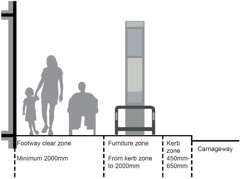
Coordinating street furniture in a consistent arrangement ensures an unobstructed section of footway for pedestrian use and further demarcates a separation between vehicles and pedestrians.
Depending on their use and level of activity streets may require significantly more than a 2-metre clear zone. It will not always be possible to include pavement space for all types of street furniture or planting zones.
Chapter 4.7 Street Trading / Commercial Activity (Including Tables and Chairs) of this document contains detailed guidance concerning commercial tables and chairs on the highway.
Guidance
Frontage zone:
Not every street will have a frontage zone. Where a frontage zone is present:
A. Wherever possible this zone should be kept free of street furniture to enable visually impaired people who use canes to navigate the street using the building line; and facilitate dwelling around retail frontages.
B. In some locations commercial tables and chairs may be appropriate to locate in this zone
Footway clear zone:
A. The clear zone should be entirely free of obstructions to allow for unhindered pedestrian movement along the footway.
B. The width of the clear zone provided should relate directly to the character and use of the street, and in particular the volume of pedestrians.
C. The footway clear zone should be designed to comfortably accommodate peak pedestrian demand alongside necessary service activity.
D. The footway clear zone should be at least 2 metres wide (excluding street furniture and other items)
Furniture and planting zone:
A. A furniture zone should only be provided where suitable clear footway widths and kerb zone widths are deliverable and should only exist where there is a requirement for furniture.
B. The zone should normally be adjacent to the kerb zone starting 450mm from the face of kerb.
C. Where there is no need for street furniture a zone may not be provided.
D. Where footway widths are narrow, essential street furniture may be located tight against the property boundary to prevent obstructions and hazards to road users.
E. Where there is generous space available, additional furniture may be positioned where this contributes towards secondary functions of the highway in place shaping or promoting commercial activity.
F. 2 metres clear width is in addition to the furniture and planting zone
Kerb zone:
A. Should be kept completely free of street furniture to prevent damage from vehicles overhanging the carriageway edge and be a minimum depth of 450mm
The Pedestrian widths for comfort (Pedestrian Comfort Guide)
The below images (figures 6 – 8) show how pedestrian flow will affect minimum width requirements
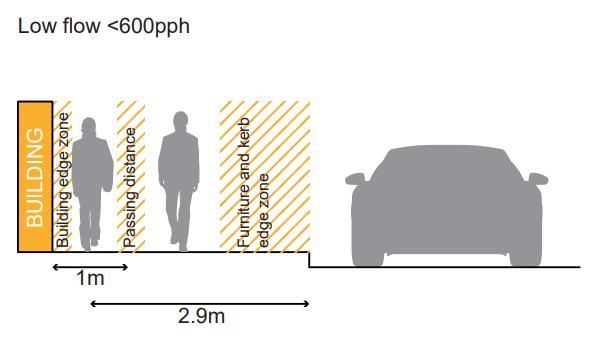
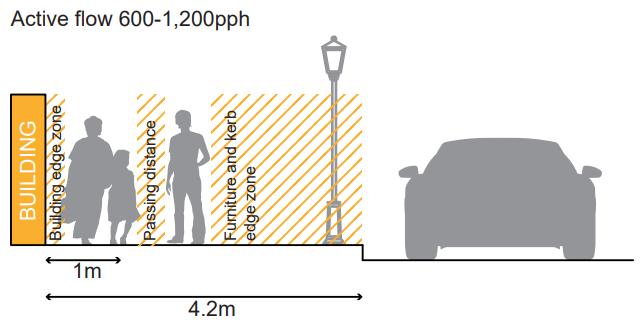
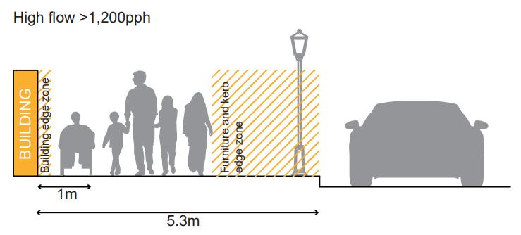
Some of Westminster’s key tourism sites would fall within the high flow category, such as the approaches to Leicester Square and Trafalgar Square. Other destinations, such as Oxford Street and other streets with active frontages, can also be high flow areas during peak periods. The widths at these sites will be protected, and consideration given to widening pinch points
Kerbs
Road kerbs serve a number of purposes:
• Retaining the carriageway edge to prevent 'spreading' and loss of structural integrity
• Acting as a barrier or demarcation between road traffic and pedestrians or verges
• Providing physical 'check' to prevent vehicles leaving the carriageway
• Forming a channel along which surface water can be drained
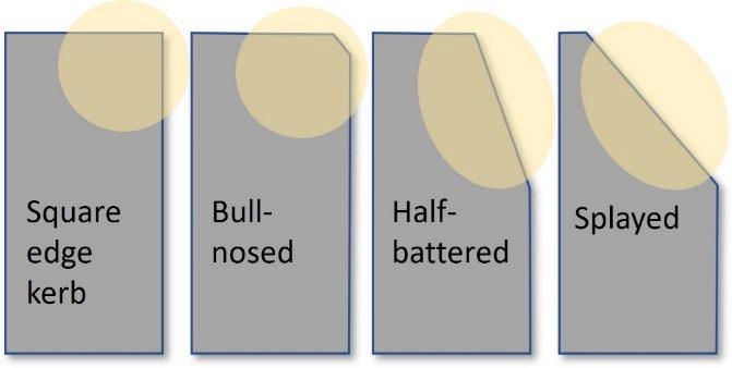
Kerbs Guidance:
A. The use of half-battered or splayed kerbs may be beneficial where cycle needs are identified. These must need to be balanced with the need to discourage vehicles from mounting the kerb.
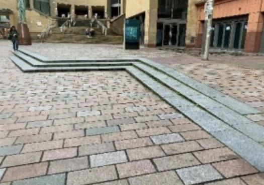
Uneven steps can be confusing and cause trip hazards Particular care is required at ramps and steps to avoid disguising the gradient or the distinction between steps and risers Whilst ramps can improve accessibility for some, others have difficultly using ramps, making a ramped route undesirable as the only route option.
A. Level access should be provided wherever possible.
B. Level access into sites and building should be provided within the site/building itself and not through change or intervention to the highway (including footway). Any steps or ramps within the public realm should comply with the standards set out in BS:8300-1
C. Steps and ramped surfaces should be clearly defined to help people avoid unnecessary hazards.
D. Where any change of level of 1:20 occurs in an access route, ramped access should be provided, within a range of 1:20-1:12
E. Gradient of ramps should be no steeper than 1:12.
F. Unless the change in level is less than 300 mm a stair should be provided in addition to a ramp
G. Steps should have consistent height (‘rise’) and tread depth (‘going ’) and should be safe in all weather conditions
H. Handrails between 900-1000 mm in height should be provided on both sides of staircases (rather than on both sides of individual steps)
I. Handrails should be made of material that is resistant to heat and cold, and visually contrast against their surroundings
J. Rest space should be provided between flights of stairs.
K. Lifts are required where there is a substantial change in level, and these should be located as close as possible to other access routes
L. The use of tapered or fading steps, as shown below, are not generally supported
M. Eye-level signage should indicate with a map/plan alternative step-free routes and access options for those unable to use steps.
N. Ramps and steps should be lit to at least minimum standards.
O. BS8300 recommends a minimum of 100 Lux at tread level.
For further guidance, please refer to the Lighting Master Plan.
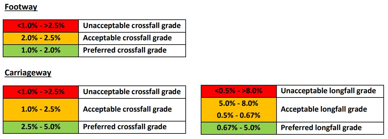
A. The following crossfalls should be taken into consideration as part of any scheme, to ensure pedestrian comfort and safety (trip hazards), and also vehicular safety. This includes gradients between the public highway boundary and proposed kerb alignment as well as carriageway long fall gradients.
Shared spaces
Vehicles crossing pavements can be disproportionately problematic for vulnerable pedestrians, and the City Council aims to reduce conflict between pedestrians and motor vehicles.
Exceptions may be made to facilitate service vehicles, although these should only occur during clearly specified timed periods, when pedestrian flow is expected to be low. Spaces with varying access throughout the day should be clearly signed as such.
Special Pedestrian and Cycle Zones (PCZs) (School Streets) can be used to create safer spaces outside schools’ main entrances, during school drop-off and collection times, as a key part of our ‘School Travel Plan Programme’ to encourage pupils to walk, cycle and scooter on school journeys. In this way, ‘School Streets’ have been trialled in Westminster since January 2020, using Experimental Traffic Orders (ETO), for up to 18 months. Vehicle movements are reduced during the operating times, with signage on the roads informing drivers of the times of operation at the entrance(s) to the zone.
Shared Spaces Guidance:
A. Where shared spaces are acceptable, they should be clearly demarcated, with a change in materials, textures, signage, or other methods to make clear to all users of the space that there is a share function there.
B. Shared spaces between cyclists and pedestrians may be accepted, where these are considered desirable for improving cycle and walking permeability.
C. Where shared spaces between cyclists and pedestrians are considered acceptable, careful consideration should be given to the design of the scheme to ensure that pedestrian priority is re-enforced, and cyclists are encouraged to move in consideration of all road users and the speed limit indicated
Guidance for vehicle crossovers is provided online here: https://www.westminster.gov.uk/roads-and-travel/roads-andhighways/vehicular-crossovers-application-forms-and-advice
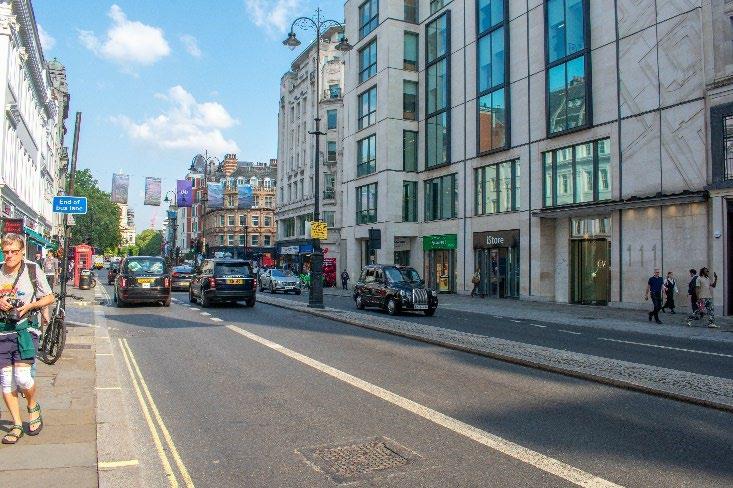
Carriageway widths
Carriageway widths will vary according to the function of the highway, roads that serve as public transport routes or trunk roads will require greater widths than roads serving less strategic functions.
The Building Regulation requirement B5 (2000) concerns ‘Access and Facilities for the Fire Service’. Section 17, ‘Vehicle Access’, includes the following advice on access from the highway:
• There should be a minimum carriageway width of 3.7 metres between kerbs;
• There should be a minimum gateway width of 3.1 metres;
• Fire service vehicles should not have to reverse more than 20 metres.
Carriageway Widths Guidance:
A. Smaller residential streets should provide a minimum of 4.1 metres for general traffic, excluding any space for parking, or dedicated cycle lines.
B. Where carriageway space permits, a minimum of 2 metres (on either side) may be dedicated to parking, subject to other highway and planning considerations and requirements being met – with an absolute maximum of 2.4 metres where space permits.
C. Where parking occurs on both sides of the road or where the available carriageway width is not enough to allow vehicles to pass in both directions, double yellow lined passing places should be considered
Bus routes and shelters
Highways that serve as bus routes are likely to be important for pedestrian movement. Bus shelters provide respite for pedestrians but in many places of high footfall run the risk of obstructing pedestrian flow. During development of Westminster’s Inclusive Design Guidance (see appendix 1), stakeholders state that bus lane bypasses are a key barrier for people with visual impairments, older people and people with mobility impairments accessing public transport stops.
Bus Routes and Shelters Guidance:
A. The safety of passengers is most important, both while waiting at bus shelters and whilst walking to and from them
B. Bus shelters should be within a walking distance to key community facilities, shopping and business areas.
C. They should help connect transport modes
D. They should not obstruct pedestrian flow
E. They should be provided at intervals of 300-400m along a route.
F. Vertical and horizontal stepping distance from kerb to and from buses should be minimised for users.
G. Carriageways that serve bus routes should not generally be less than 6m wide, excluding any space dedicated for parking.
H. Short sections that are narrower may be acceptable where visibility is clear, but an absolute minimum of 4.8m should be maintained.
I. Areas where buses can pull into the left should only be accommodated where the pedestrian widths above can be maintained, and only on carriageways where high traffic flows justify the need.
J. Pedestrians should be able to access bus stops without crossing cycle routes
K. Where this is not possible due to strategic cycle route provision, consideration should be given as to how to make the cycle route clear to pedestrians
L. Bus shelter access should not be compromised by street furniture
M. Shelters should contrast visually with the background against which they are seen
N. They should provide suitable weather protection
Intersections and crossings
Junctions and crossings are often the site of collisions and conflict for users of the highway. The most recently adopted Highway Code sets out a system of priority for road users when using un-signalled junctions 41 The availability of formal crossings is particularly important for visually impaired people Consistency is critical to aid accessibility. Raised tables where the carriageway is raised to footway level (also known as raised carriageways), can provide a more comfortable and accessible walking environment, are easier for disabled people to negotiate, and reduce the risk of ponding at the bottom of dropped kerbs Raised tables can also act as traffic calming, slowing traffic.
Within Westminster, most traffic light-controlled crossings are timed, and this is managed by TfL. However, the timings for the pedestrian crossing period are often short, and in some areas, a significant subset of pedestrians cannot cross the road in the allocated time. The City Council works with TfL to introduce new timed crossings under our Pedestrian countdown at traffic signals (PCATs) programme.
The aim is to visually and physically reinforce pedestrian priority, reduce crossing lengths, and improve crossing accessibility and safety
The installation of tactile paving provides clarity of routes for people with visual disabilities.
Crossings Design Guidance:
A. Road design should reflect the Highway Code hierarchy, and support vulnerable road users.
B. Crossing designs should be consistent and easy to recognise by pedestrians and drivers.
C. Crossing routes and points should be suitably designed to ensure ease of use by all potential users, with materials of colour contrast, tactile paving (see materials guidance below) and other appropriate audio and visual signals.
D. A colour lighter than the general road surface should be used for built crossings to aid the visually impaired
E. Step-free crossings should be provided either by way of a dropped kerb or raised crossing
F. Shared surfaces which provide no tonal/surface contrast between pedestrian/cycle/vehicle areas create confusion and will not be supported.
G. Where in exceptional circumstances shared surfaces are allowed, they should include formal crossing points
H. Zebra crossing paint can be used to indicate pedestrian priority in turnings to minor roads
41 This relates to Rules 170 and H2 of the Highway Code: ‘Give way to pedestrians crossing or waiting to cross a road into which or from which you are turning. If they have started to cross they have priority, so give way (see Rule H2).’
I. Innovative design features to emphasise pedestrian priority can be explored. However, these should not distract from delivery of a cohesive legible public realm
J. When designing such crossings, consideration should be given to different types of pedestrians, in particular those with visual impairments and wheelchair users.
K. Zebra crossings should be retrofitted into junctions around areas of high pedestrian flow where appropriate.
L. Colourful crossings, such as those incorporating artwork on a pedestrian crossing facility, are not generally supported in Westminster.
M. Junction re-designs which enlarge pedestrian or cycle routes and prioritise their safe movement will generally be supported.
N. Dropped kerbs at crossing points (including junctions) should have a corresponding dropped kerb at the other side of the crossing, including at borough boundaries. Any public realm improvement works should rectify this, where this is not already in place.
O. Uncontrolled crossings should only be installed in low traffic streets.
P. Crossing distances should be minimised.
Q. Crossings may need to be repositioned to avoid steep dropped-kerb gradients and reduce crossing distances.
R. If repositioning a crossing is not possible to avoid a steep gradient, a raised table (road crossing raised to the same level as the pavement) should be considered.
S. Raised tables can additionally benefit traffic management by helping to reduce vehicle speeds and should be considered where traffic calming is a priority.
T. Raised tables are only appropriate in streets where traffic volumes are low.
U. Raised tables are preferred for uncontrolled junction crossings.
V. Two stage crossings should be avoided, except on main roads or roads with bus lanes on either side.
W. Pedestrian islands on single stage crossings may be acceptable, where crossing distances are particularly wide.
X. Junction angles should be kept as close to 90 degrees as possible to slow down traffic turning. Exceptions to this will be considered for roads commonly used by larger vehicles and follow a swept path analysis to ensure that larger vehicles do not overhang the kerbside.
Y. Wherever possible, crossings which reinforce pedestrian priority should be used.
Z. Installation of bollards at crossing points should take account of access requirements of all users, including wheelchair users and their safe turning needs
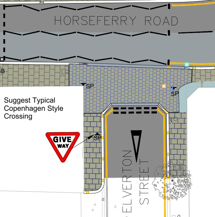
Figure 14: Example design of a crossing which reinforces pedestrian priority.
Lower occupancy vehicles
Taxis
Drop-off points exclusive to taxis use do not exist. A drop-off point could be a single or double yellow line but available to any vehicle.
Taxi Ranks:
A. Taxi ranks should be provided in places identified as having the greatest value to residents, visitors, and workers in Westminster, particularly as some people with disabilities are unable to use public transport.
B. Locations should be identified through liaison with relevant stakeholders.
C. Kerb heights at taxi rank pick-up points need to align with taxi floor heights to enable easy access into vehicles.
Car Clubs
Car Clubs Guidance:
A. Generally, flexible car club schemes without dedicated parking spaces are preferred, because they remove the need for Traffic Orders that are costly and time consuming to introduce.
B. The City Council will look to accommodate dedicated Roundtrip Car Club bays, noting that this is the preferred operating model for some suppliers.
C. Appropriate demand levels will need to be maintained to justify the existence of the bay.
On-Street Vehicle Parking
Westminster's City Plan policy (policy 27) is that new development should be car free, including residential development (except for disabled parking) . Any proposals for new parking in association with new floorspace should comply with the parking standards in adopted policy.
The standard kerbside parking bay is around 1.8 - 2 metres wide and 5-6 metres in length and should remain so where kerbside parking is considered appropriate. Modern vehicles have been increasing in widths considerably, with some SUV models being over 2 metres wide. Notwithstanding this, wider parking widths cannot be accommodated on Westminster’s busy and historic streets – especially without compromising carriageway widths. The council will not seek to accommodate wider vehicles, which are generally not appropriate on Westminster’s narrow streets.
On-Street Car Parking Guidance:
A. Where car parking is required, this should be in line with standard parking bay lengths.
B. Disabled parking spaces must be provided in accordance with The Traffic Signs Regulations and General Directions 2016 and should ensure adequate length to enable users to load and unload wheelchairs, and other mobility aids.
C. Signage notifying of pay-by-phone payment systems should be positioned close to accessible parking spaces.
D. Where existing parking space is not required or undesirable, the City Council will explore the re-allocation of this space.
Highway re-allocation
In some parts of Westminster, it may be suitable to restrict the use of the highway to certain users only, whose use of the highway generally requires less space – enabling the highway to accommodate a diverse range of uses. Re-allocation also can occur where carriageway widths or parking spaces are affecting pedestrian comfort. In appropriate locations pavements may be widened to accommodate trees with appropriate drainage, SuDS, or cycle hangars. Reallocating carriageway space for pedestrians and cyclists can improve the public realm, pedestrian and cyclist comfort and slow the speed of traffic.
Highways Space Allocations Guidance:
A. Where these re-allocations occur, there will be a presumption in favour of pedestrian comfort and mobility, while accommodating where possible improved permeability for cyclists.
B. Provided that any enhanced pedestrian widths are not compromised, alternative highway allocations can be considered – and would need to have clear public benefit to offset any detraction from the primary use of the highway for movement.
C. Third party use of highway space cannot detract from the primary use of the highway for movement.
Figure 15: Wellington Street, where reallocation of highway facilitates a range of uses, including commercial activity, bike hire stands, and servicing spaces, while continuing to provide comfortable permeability for cyclist and pedestrians.
Parklets
Parklets are temporary structures, often located in former parking spaces, and often providing seating, and planting, and sometimes cycle parking. Parklets can respond to the growing demand for greater pedestrian space, greener kerbsides and a more liveable urban realm.
The appropriateness for installing parklets compared to other kerbside activities will be covered by the City Council’s emerging Sustainable Transport Strategy. They can be difficult to maintain and take away space from other kerbside activity. In general, Parklets are seen as an intervention within the highway of last resort.
The City Council will consider parking occupancy, single yellow line availability, local land use, road safety and sightlines, accessibility and data regarding on-street issues to inform if a location is suitable for the installation of a parklet.
Where parklets are installed, it is important that they are used as public spaces and not be used to serve commercial uses nearby.
Parklets provided and maintained by third parties, require planning permission and S115E licence S115E licenses give third parties permission to put something on our highway. The licence can stipulate conditions for maintenance. The community group, resident association, or business, that has made the application to install the parklet, becomes the parklet owner and is responsible for the parklet’s management and maintenance, through a Management and Maintenance agreement with the City Council. These should include:
• general maintenance and repairs to the structure of the parklet (i.e. to fixed items and furniture)
• plant maintenance, including water supply
• cleaning and upkeep
• removal of the parklet
The parklet owner is responsible for making sure the parklet is kept in good condition and is safe and comfortable for all users, e.g., fixing a broken seat or replacing dead plants. The parklet owner will need to ensure repairs are completed promptly, and to a good standard.
For any parklets maintained by the council, these will require a commuted sum to be agreed and paid to the council prior to installation to cover future maintenance costs
Parklets Guidance:
A. Parklets should only be considered a temporary intervention.
B. Permanent/long term landscaping solutions (including street trees) would be preferable.
C. As part of the design proposals for parklets, drainage requirements and obstruction or potential trip hazards must be considered.
D. Guidance in relation to planters also applies to proposals for parklets.
E. A Road Safety Audit is required for the installation of any parklet in Westminster. This is to mitigate any issues or problems associated with a parklet that might affect users of the public highway.
F. A Traffic Management Order will be required to change any kerbside control (parking bay, lines and signs) to enable the parklet to be on the carriageway.
G. Third parties installing assets will require planning permission and an S115E licence
H. Costs will also need to be held to return the carriageway to its previous operation if the parklet is then removed.
I. Public liability insurance up to £5 million of third-party claims is required.
J. The success of parklets will be kept under live review.
K. The City Council supports proposals for pocket parks and parklets only where they do not compromise desire lines; pedestrian safety; and/or parking need, and where they do not detract from the character or appearance of the area.
L. Parklets should not cause trip hazards or any safety issues.
M. The parklet owner will be responsible for making sure the parklet is kept in good condition and is safe and comfortable for all users, e.g., fixing a broken seat or replacing dead plants.
N. The parklet owner will need to ensure repairs are completed promptly, and to a good standard