Chaitali Pradeep Bhanushali
M. Urban Design ; B. Architecture

Innovative and desirous Urban Designer-Architect driven to push creative limits with cutting edge Urban Design concepts for Avant grade public spaces; o ering strong knowledge of the di erent stages of Architecture and design development; possess strong ability to catalyse creative ideas towards sustainability and resiliency in the face of rapid urban change.


Highly motivated and determined individual seeking opportunities for bringing exceptional ability to employ creativity in designing processes; ingeniously integrate urban disciplines into spatial design proposals; confront critical issues a ecting cities including climate change, population growth and transforming infrastructure, and promoting alternative models for futuristic city-building in a time-e cient manner.

Skills
Professional Membership
Adobe Illustrator Architect Registration number CA/2019/106613
Adobe Photoshop
Adobe InDesign
Rhino 3D
Experience
Grasshopper
AutoCAD
Sketchup 3D
Microsoft O ce
Community Engagement
Interviewed for ‘Humans of RMIT’ community.
Videographed for studying from home in ‘RMIT NEXT’.
Marketing Volunteer for ISANA, VicWISE.
Urban Designer Fishermans Bend, City of Port Phillip
Urban Designer, Hume City Council
Strategic Planning/Urban Design O cer, City of Melbourne
Urban Designer, Gaage Developments
Project Architect/Assistant Urban Designer, Monash City Council
Visual Data Mapping, Melbourne Metropolitan.
Rejuvenating Brunswick.
Urban Renewal project, Melbourne CBD.
Building communities, Barcelona.
Bio Diverse Decentralised Cities, China.
Airport Passenger Terminal, India.
Rejuvenation Enterprise Park, Melbourne.
Designing Future Residential Suburb, Seymour.
Architectural Designer, The Great Stupa, Bendigo.
Mentor at RMIT Mates.
Stood for General Secretary in student Council elections.
Nominated for Academic Board Elections 2019.
Volunteer for Australian Federation of International Students.
Achievements
Urban Design Student Representative in SSCC.
Moderator for a panel at International Student Summit 2019.
Featured in Herald Sun with Study Melbourne.
Featured volunteer on social media, RMIT Student Union.
Global Leadership Experience Student Ambassador.
Student Ambassador RMIT, 2019.
Earned below credential badges to boost my employability skills
Decentralised Bio Diverse cities- Taihu, China
Future Residential Suburb, Seymour
Much More Moreland, Brunswick Design District
Airport Passenger Terminal, India
Building Communities, Barcelona
Rejuvenating Enterprise Park, Melbourne
Monash City Council
Urban Renewal, Melbourne CBD
Mapping Issues of Mumbai City
Design Strategies, Asian Urbanism
City of Port Phillip


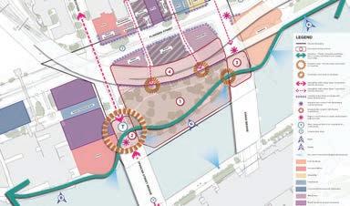
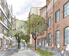
Lead the development of guidance on the function and design of streets, lanes and verges in Fishermans Bend, collaborated with stakeholders within Port Phillip and Fishermans Bend Taskforce to progress the design of the Fishermans Bend public realm and deliver a set of concept/functional designs to guide planning referrals and capital projects.
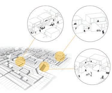
Developed functional layouts, Public Realm framework, written design guidelines for streets, laneways and open spaces, and communication graphics to guide the Council o cer, developers, and the community for future streetscape designs across Montague Precinct in Fishermans Bend.


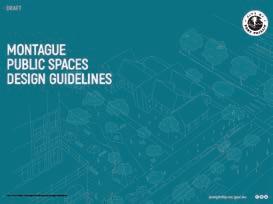
Prepared Urban Design Framework to inform the vision set in Montague Precinct Implementation Plan which includes streetscape functional layout, material speci cations to set a standard street character, and design guidelines to achieve the objectives set in Montague Public Spaces Design Guidelines Document.
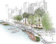
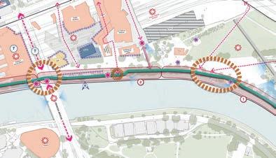
Fishermans Bend: Urban Structure
BUCKHURST STREET (WEST OF MONTAGUE STREET)
BUCKHURST STREET (WEST OF MONTAGUE STREET)
Fishermans Bend: Public Transport
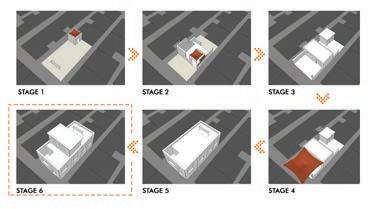
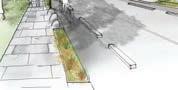
Hand Drawn illustrations of Future Streetscape Designs
Hume City Council
Overseen Activity Centre and neighborhood public realm improvement programs. Facilitated urban design projects, including organising and prioritising complex tasks required in project management, leading and collaborating with multidisciplinary project teams, procurement and supervision of consultants and ensuring time and quality requirements are met.
Developed and maintained relationships, engaged with internal departments, government agencies, stakeholders and relevant authorities to provide best practice urban design guidance for projects and initiatives across the City, including the development of Council’s property portfolio.
Prepared Urban Design Framework Maps for Precinct Implementation Plans by analysing Strenghs, Weaknesses, Opportunities and Threats to determine economic, design and development strategies for various precincts in the Hume Municipality.
City of Melbourne
Provided strategic, creative and spatial design advice to achieve Council’s urban development strategies and major initiatives through e ective visual and graphic communication on Macaulay Structure plan, Macaulay Open Spaces, Development Contributions plan, Built-form study, Tactical Urbanism for City Reactivation and conceptual illustrations for Fitzroy Garden Pavilion and pedestrian oriented streets in Macaulay.
Provided Urban Design Advice through analytical research and design development on Greenline project, a major initiative to help transform Northbank alongside Yarra River – Birrarung towards a revitalised and refurbished public realm while achieving active civic engagement spaces.
Developed Urban Design critical analysis through strategic documentation of Yarra River interface by means of historical and heritage signi cance mapping; and established spatial typologies across river’s diverse edge conditions from Birrarung
Marr Precinct to Salt Water Wharf Precinct that informs the preparation of the strategic precinct framework for the Greenline Implementation Plan.
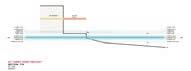
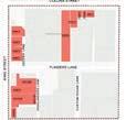
3.4 BOUNDARY PRECINCT LINEAR OPEN SPACE (North)
3.4 BOUNDARY PRECINCT LINEAR OPEN SPACE (South)
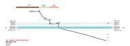
Strategic Vision (Moonee Ponds Creek Strategic Opportunities Plan)
Victoria Harbour Opportunities Plan
Moonee
Macaulay Structure Plan: Transport Network Mapping
Moonee Ponds Creek Civic Overflow Route: Create an overflow creek pathway, as linear open space, behind the levee between Racecourse Road and Macaulay Road to accommodate the over-topping of the levee at Racecourse Road.
Design objectives
• Implement a 3m wide concrete shared user path extending from Macaulay Road to the southern boundary of 59-101 Alfred Street. This path seeks to provide a key pedestrian and cycle connection from Macaulay Station to Royal Park.
• Acknowledge the approved planning permit at 59-101 Alfred Street comprising a new vehicle connection along the western boundary. Ensure the shared user path provides adequate transition to manage the change in traffic conditions for pedestrians and cyclists.
Provide a separated paved pedestrian path, primarily aligned along the adjacent to building interfaces to enable uses to spill from new development minimizing conflict with north-south cycle movement along the shared path.
• Implement new trees adjacent to the pedestrian path, to provide shade and green outlook to building frontages abutting the open space.
• Implement flexible lawn areas for passive recreation and seating.
Frame paths and lawn areas with new native understorey planting to guide movement through the open space and provide green outlook from adjacent developments.
• Implement 1 fitness station or active recreation nodes with integrated rest areas in proximity to Alfred and Sutton Streets.
• Implement a small play node south of Sutton Street. Opportunity exists to collaborate with public artists as a curated design feature of the open space. Implement a multi-use court and basketball hoop to the south of the reserve, adjacent to picnic nodes or seating areas. Implement a bike repair station at the southern end of the trail near Macaulay Station.
• Integrate frequent seating nodes along the shared user path and flexible lawn area.
• Implement lighting along the shared user path to enable use of the corridor for pedestrians and cyclists at night.
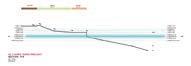
Strategic Vision (Moonee Ponds Creek Strategic Opportunities Plan)
Moonee Ponds Creek Civic Overflow Route: Create an overflow creek pathway, as linear open space, behind the levee between Racecourse Road and Macaulay Road to accommodate the over-topping of the levee at Racecourse Road.
• Enable safe and convenient access into small local open spaces or shared zones at the western end of Mark, Sutton and Alfred Streets.
Precedent Projects
• Align the design of the linear reserve with potential future open spaces and shared zones at the end of Alfred, Mark and Sutton Streets.
• Accommodate wayfinding signage on approach to side streets and major roads within the precinct to guide pedestrians and cyclists to civic destinations and services.
• Acknowledge the potential future station upgrade of Macaulay Station and potential future access to the open space from the northern end of the station.
• Consider potential future pedestrian links through private land to the linear open space.
• Continue to investigate opportunity for future expansion of open space into the undercroft of City Link, subject to land negotiations with Victrack.
4.
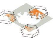
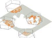
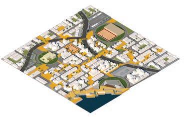
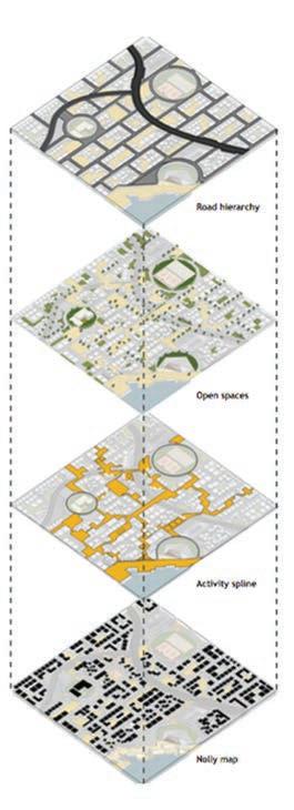
Mapping Melbourne
This project was about investigating the complex relationship between the physical form and its rmware, the operating system of the cities.
I worked on live dataset extraction on Grasshopper 3D to generate visual spatialisation based on designed mapping tools to graphically represent the statistical data.
The focus was to hybridise disparate datasets from public services and entities like web-based Application Programming Interfaces (APIs) and extracted into design environment. Live datasets help to determine the behavioural pattern of di erent characterstics like walkability, liveability, employment and population.
mapping
The maps determine the walkability catchment area and the intensity of walkability within residential and commercial spaces. It shows the level of walkability is relatably low in the outer region than the central part of Melbourne.
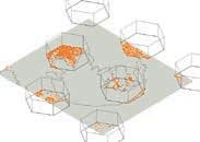
Decentralised Bio Diverse cities Taihu, China
Access is power. Access to jobs, access to services, access to open space, and access to transportation gives people choices in life.
Throughout the world, there is increasing inequality in people’s ability to unlock these necessities in life. We, therefore, delved into the rules and implications of creating a decentralised city and their e ectiveness in addressing these concerns. What if everybody lived in cities? What if we have multiple cities instead of just one?
Could a decentralised city be the solution to socially sustainable development?
This project is therefore hopeful that a more equitable world is possible, while also giving agency to the environment as it begins to ght back.
The project focused on iterationas and testing out di erent urban design strategies as a responsive approach towards growing population and rapid urbanisation trend.
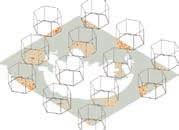
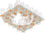
We looked at what if cities were at X distance limitation with all essentiat amenities and services easily accessible within that periphery. Looking at the brighter side, we would no longer need to travel longer hours to get to the city or a central commercial hub for work.
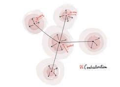
We tested out cities of 5km radius to 25km radius and corresponding to the average walkable distance covered by single person, which evaluates to be a 5km city in a walkable boundary to avoid vehicle usage and encourage pedestrian interaction and network.
6.


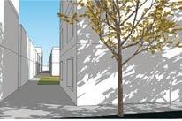
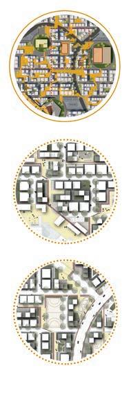
Much More Moreland Brunswick Design District
Brunswick is known to have its own character which has been valued and recognised by its creative capabilities by amalgamation of distinct sectors of art, design and culture that ties together peculiar precincts.

The initial phase of research involved mapping those distinct industries of innovation and design and de nes the archipelago of the district based on visionary and expressive threshold.


The mapping determined sites of potential that envisioned growth and a binding element to enhance the characteristics. The dynamic role as an Urban Designer lead us to think about di erent propositions into various iterations to highlight the potential of the precinct. It was basically lling gaps in those areas with innovative primary functions to complete the networked loop.


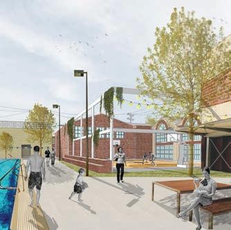
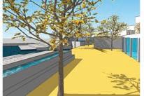
 View 01 : showing a roof top restaurant built over dead end Woolworths wall with a market space below
Creative Mapping of Brunswick Sydney road and around
Block model of proposal
View 02 showing an art gallery cafe opening to a sports court with a minimal barrier opening to Brunswick Public Baths
View 01 : showing a roof top restaurant built over dead end Woolworths wall with a market space below
Creative Mapping of Brunswick Sydney road and around
Block model of proposal
View 02 showing an art gallery cafe opening to a sports court with a minimal barrier opening to Brunswick Public Baths
7.
Building Communities Barcelona, Spain
Building communities was a hand draft inter cultural interactive workshop held in Spain to diversify the blending of old Barcelona city with the new one on a transitionary industrial area of El Poblenou. The workshop proved to be interactive with model testing on a scaled site of the city.
On an initial phase, the learning was about understanding the urbanisation and planning growth since the 1800s to date which as well involved exposure to cinematic representations of Barcelona to closely analyse the behavioural patterns and characteristics of the city to be able to purely re ect into building communities design proposal.

8.

Monash City Council
Monash City ouncil gave me a local government working culture exposure for me to be able to design and execute on site in a time e cient manner. I was honoured to be a part of Council meetings to present the initial proposal of the youth community centre and successful get the approval to be able to move ahead with constructing the design.
Later stage of my tenure in the council made me assist Senior Urban Designer where I individually worked on Mulgrave Reserve and a sports pavillion. I prepared Integrated site plans and Urban design solutions were bestowed.

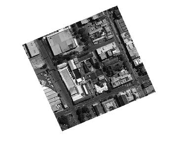
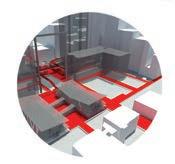
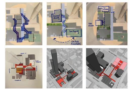
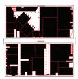
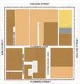
Urban Renewal, Melbourne CBD
Hoddle grid blocks could sometimes get monotonous with high rise development over shadowing pedestrian valued public spaces on ground. Our innovative approach was designing inetrconnected armature within a tight block designated space to make it entirely pedestrian friendly.
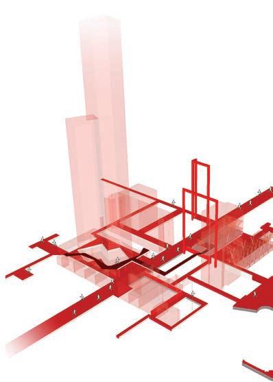
To determine this, I initially mapped the positives and negatives of a block that falls within Flinders St, William St, Collins St and King St. Every road frontage ahs di erent characteristic to speak for itself and not every street has common feature within the square periphery.
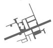
The role was to pick potential spaces that could open up to new laneways rather than ending up into a deal wall with garbage dumpings making the space unsafe and unwanted. The red armature demarkates the possibilities of a new pedestrian network interlinked to each other as one solid entity that ts into the block.
 Armature drawing, Block CBD

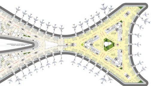
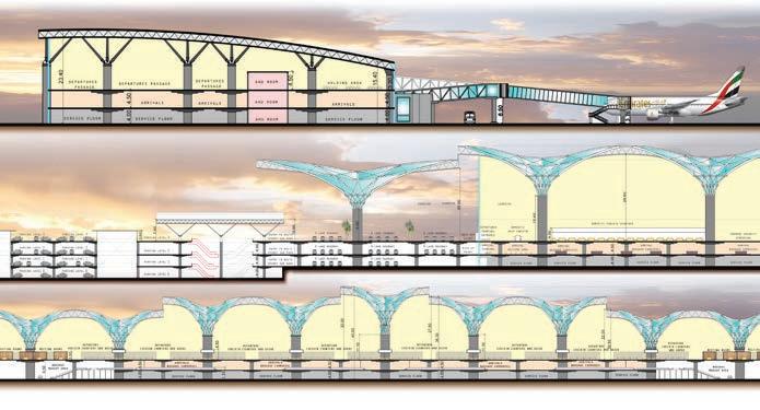
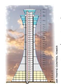
Airport Passenger Terminal India.
It was a green eld Airport Passenger Terminal project that was to be designed and constructed in two phases as a responsive design strategy towards increasing annual passenger movement.
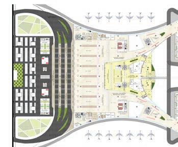
The design proposal of one passenger terminal out of the two were for 60 million passengers per year. It involved a strategic planning approach for the entrance manouevering of vehicles to enter the terminal with respect to the trafc ow to be pulled from the city. It was a terminal proposal for a satellite town named Navi Mumbai to a major town of Mumbai to relax the pressure on the Mumbai International airport.
The proposal of the terminal was designed with huge mushroom like columns made of glass and steel to invite natural light in all corners of the interiors and a central rain water catchment pipe running through the centre giving an aesthetic exposure of owing water down the columns.

Externally the facade was a kinetic design facade with aps opening and closing depending on solar exposure to avoid the direct harsh sunlight heating up the building as a sustainable and energy saving approach.
Departure Level Plan
Concept Development

11.
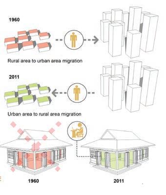
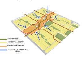
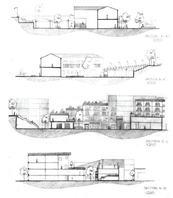
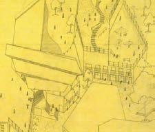
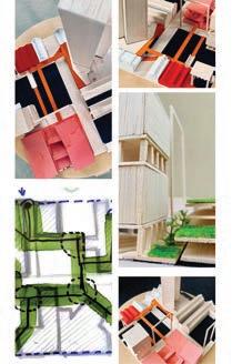
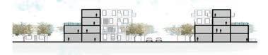
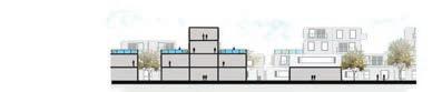
Future Residential Suburb Seymour.
It is quite challenging and et intriguing to propose a design proposal for a new green eld residential suburb.
In this design, I particularly highlighted the true essence of Melbourne city about its vibrant culture, sports and arts. With that as a driving point, the triocentric design concept was to evolve the residences surrounding the recreational characteristics.
The yellow pedestrian network was to enhance the importance of public movement and direct connectivity to courtyards and recreational centres with 2 major roads running within the suburb. The idea of courtyards envisioned a sense of community development tied up together by its true identity.
Sections
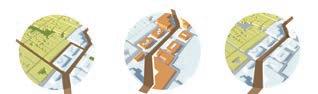
Site Mapping and Analysation
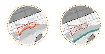
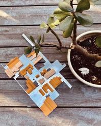
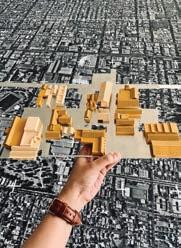
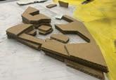
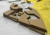
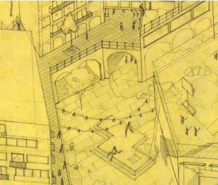
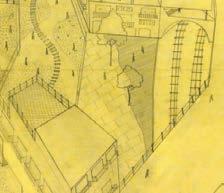
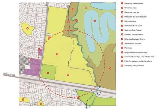
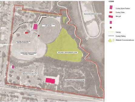
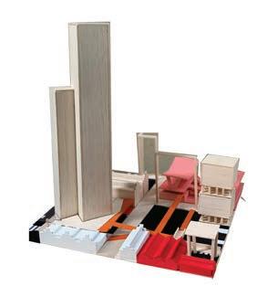
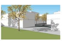
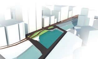
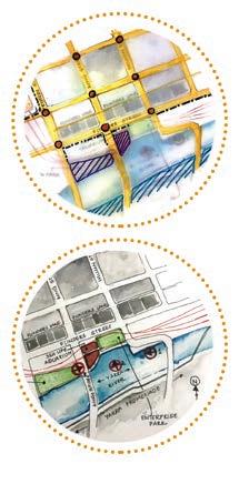
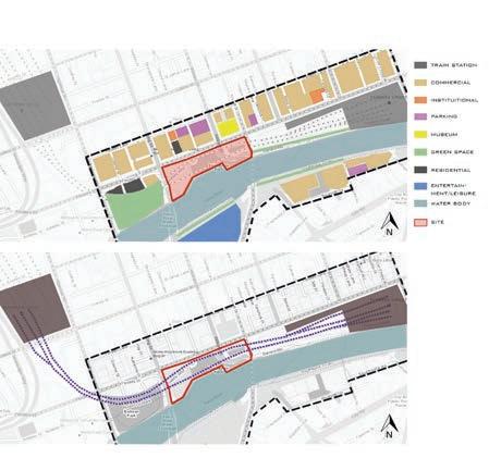
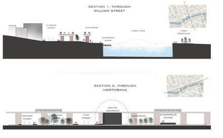
Rejuvenating Enterprise Park Melbourne.
Prior to selecting a site for a rejuvenation project to propose an Urban Design amendment strategical approach, this particular area drove my attention and made me ask a question ‘WHY is that so?’
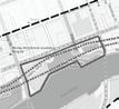
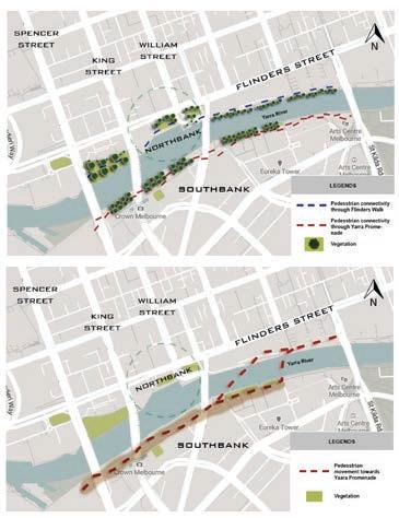
River Yarra is a common waterway between Southbank and Northbank. The Southbank promenade tends to be the most active with river side restaurants, activities, sit out spaces and public walking river bank. On the opposite side, the bank seems to be a complete dead spot with homeless habitants and absolute negative unsafe space to walk through.
It is observed that spaces opening from railway stations often are the most vibrant with continuous public movement, I proposed there a mid metro station between Flinders station and SouthernCross station as a halt to get out through Enterprise Park, thereby creating public activity to activate the area and potentially equalise with the Southbank promenade.
Sections
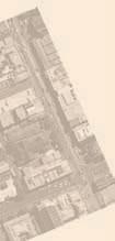
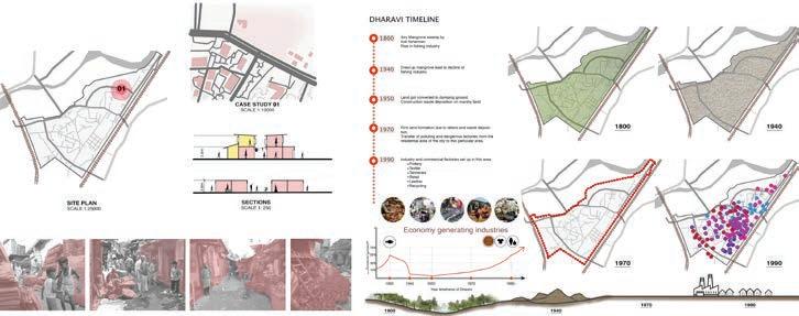
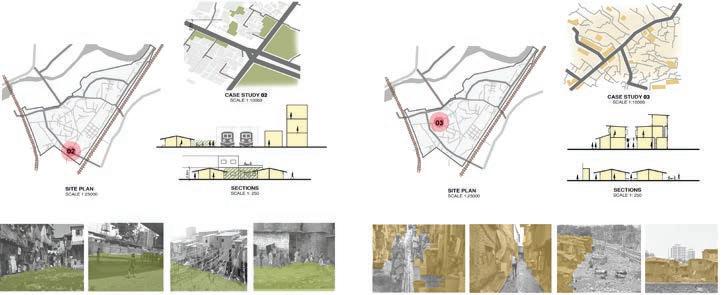
Mapping Issues of Mumbai City India.
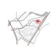
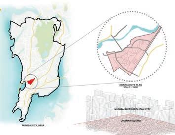
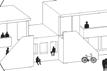
Highly populated cities demonstrate extreme and rapid changes in urbanisation to be able to cope with the infrastructure development and occupancy of the level of population within the city. If that doesnt go well hand in hand with designed and planning urbanity, it may direct to formation of temporary slum housing like the one in Dharavi, Mumbai, India.
I researched about the sustainability and survival of the largest slum in Asia, yet the most generator of economy within the widely occupied territory. Although it is a temporary housing community, I learned the planning organised system within the entire area. It tends to be the self sustainable survival city within the city.
I further mapped to visually represent and corelate with the theorotical and informative statistics of Dharavi slum. I mapped the varieties of industries that generate economy for themselves with an exquisite concept of housing merged with commercial shops on the same plot emerging as a mix use setllement site.
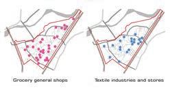
The issue of the city evolves with the rising gap between temporary slum development and luxurious high rises. It becomes challenging to super impose functional planning schemes for a better community design.
Mapping and analytical illustrations
Mapping and analytical illustrations
Mapping and analytical illustrations
Mapping and analytical illustrations
14.
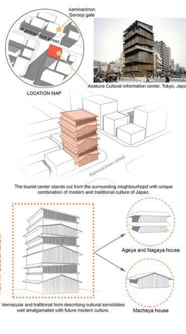
Design Strategies,
Japan, India- Urbanism
Urbanisation trends proves to be a gradual process, but with a foresight, it determines the future of di erent cities to be able to evaluate the capacity of population and infrastructure occupancy as compared to developed cities around the world.
Certainly this project was to determine how Urban Designers and Architects from Japan and India came up with design strategies to solve communal, societal and planning issues in the city.
B.V. Doshi designed an architectural and sustainable housing strategy to predominantly provide a ordable habitat with e cient planning to get rid of temporary settlements harming the urbanisation of future cities.