CEGA’s annual Core Conference is Canada’s premier rock-focused geoscience event.
Hosted in a relaxed, collaborative environment, the conference showcases core samples from across Canada alongside technical posters and presentations It’s a space where geoscientists from students to seasoned professionals can engage directly with the rocks, share insights, and explore the science that drives our understanding of the subsurface.
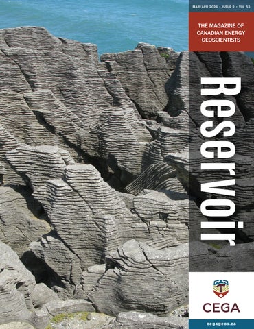
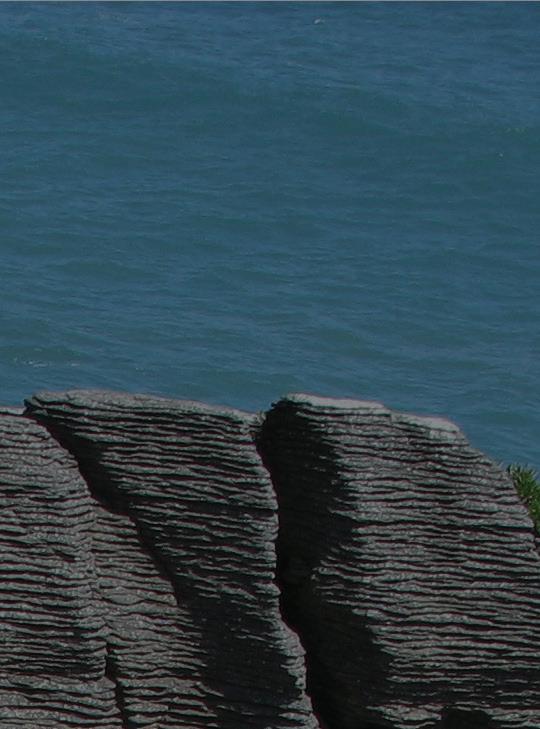
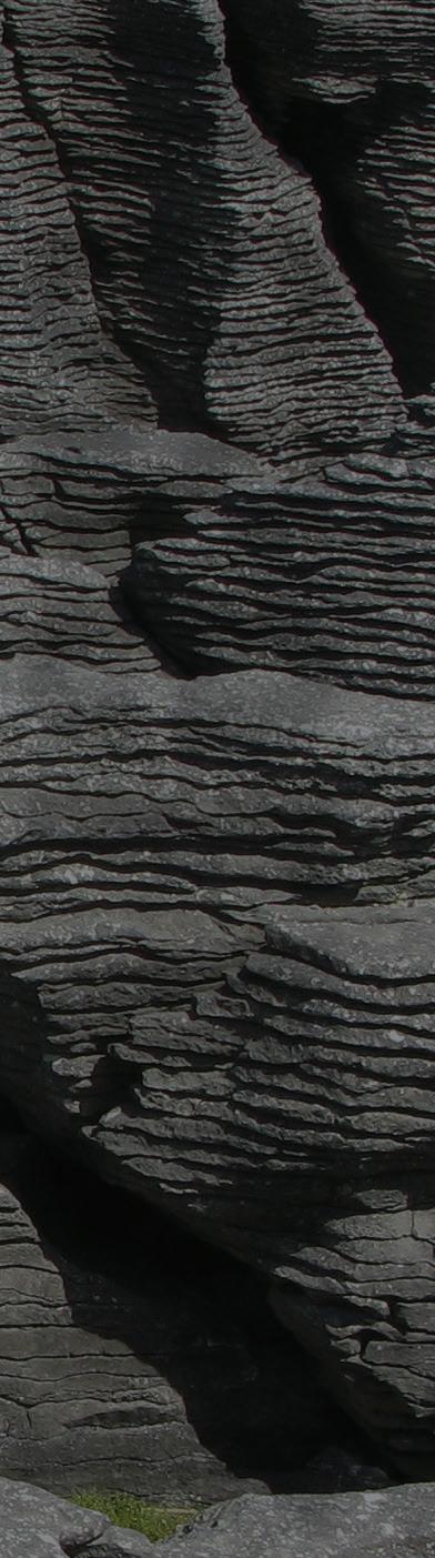
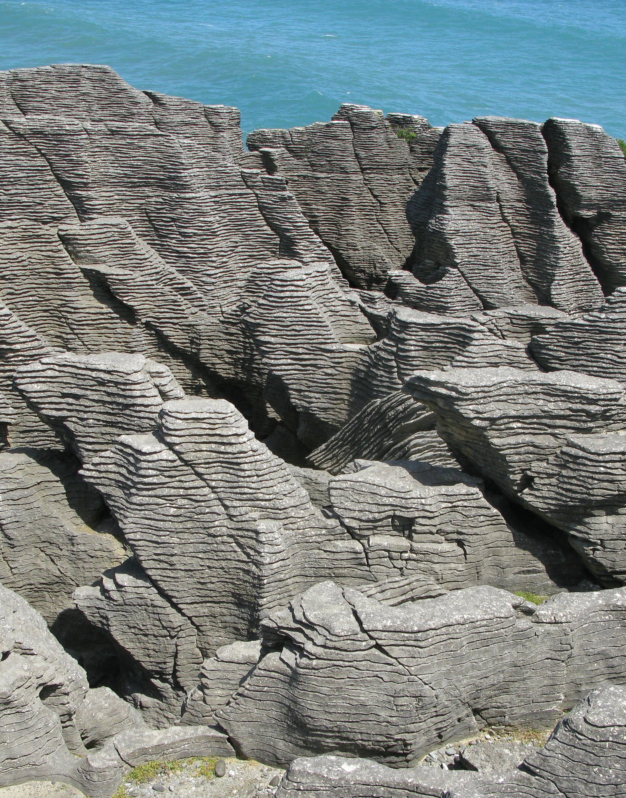
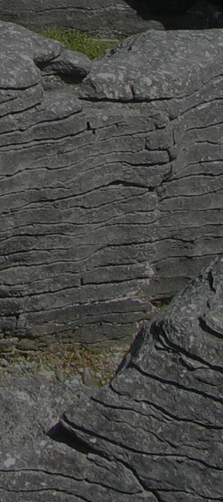
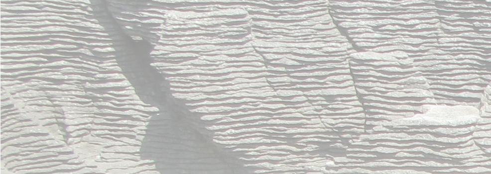
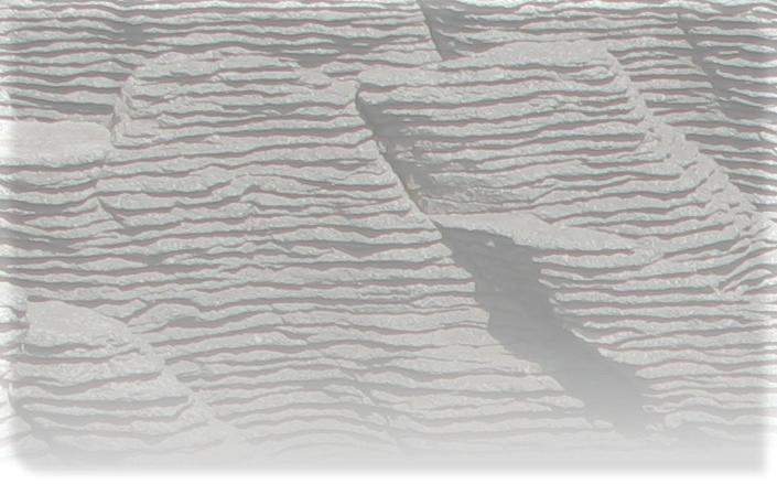
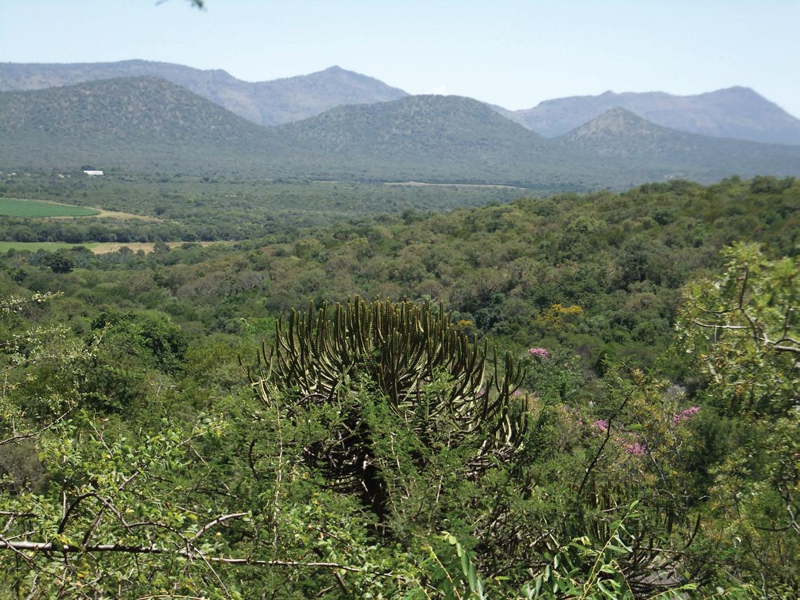
Pancake Rocks, New Zealand.
This view is looking west to the Pancake Rocks near Punakaiki in Paparoa National Park on the northwest coast of the South Island of New Zealand, adjacent to the Tasman Sea. The Pancake Rocks are a series of shallow water limestones that are part of the Oligocene Waka Supergroup. They were exhumed and exposed during the Kaikoura Orogeny that began in the Miocene and continues today, uplifting the South Island. During burial and compaction, the limestones were subjected to pressure solution. The resulting formation of stylolites involved the creation of thin layers of insoluble residue within these strata. Those surfaces became planes of weakness during uplift and erosion, leading to the creation of this distinctive layered appearance.
Photograph by: Gordon Hurlburt
FROM THE EDITOR
SARAH SCHULTZ, TECHNICAL EDITOR FOR THE RESERVOIR
WELCOME
TO OUR MARCH AND APRIL ISSUE OF THE CEGA RESERVOIR!
CEGA has great workshops focusing on stratigraphy, core logging and trace fossils scheduled throughout April and May. Technical talks are still ongoing for the luncheon division and are scheduled throughout 2026. Please check the CEGA website for registration details!
In this issue we present the continuation of our regular articles:
• From the Desk of the AER
• Geology in Motion: Examples of Geological Borders in Conflict
In this issue we present the following articles:
• 2026 Message from the Board
• Jon Noad: Platinum and Pythons
• Alberta Palaeontological Society 29th Annual Symposium
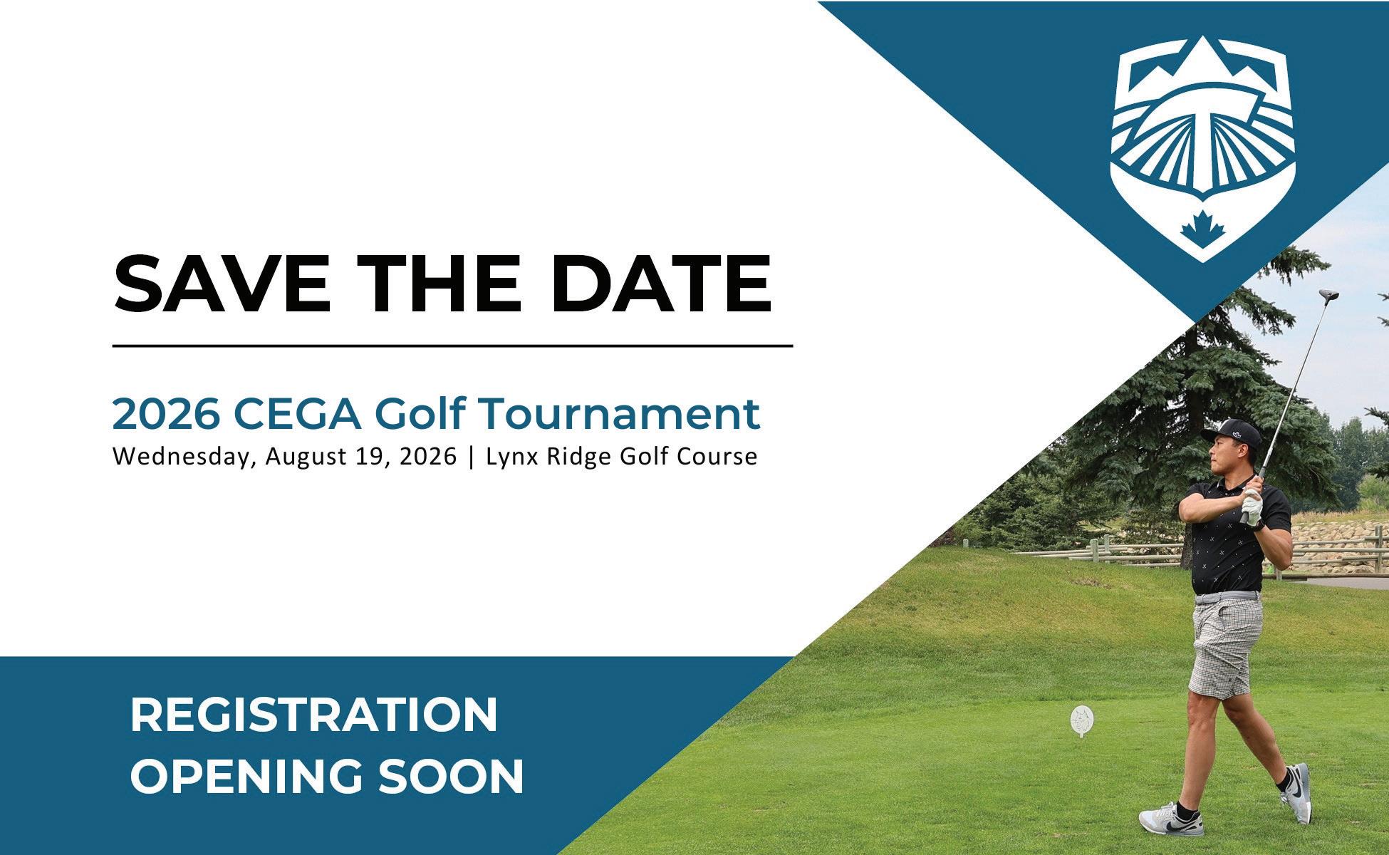
The annual Geospiel will be held April 16 – 18, 2026. Registration is open for the event.
The CEGA Bedrock Bash Volunteer Appreciation event will take place April 21, 2026 at the Unicorn. Sign up today by emailing membership@cegageos.ca!
The Geoconvention and CEGA Core Conference is scheduled for May 2026. Please check out the conference websites to register for these events.
We look forward to receiving your manuscripts for the upcoming 2026 issues of the CEGA Reservoir.
Sarah Schultz
PUBLICATION INFORMATION
The RESERVOIR is published six times per year by the Canadian Energy Geoscience Association. The purpose of the RESERVOIR is to publicize the Association’s many activities and to promote the geosciences. We look for both technical and non-technical material to publish.
The contents of this publication may not be reproduced either in part or in full without the consent of the publisher.
No official endorsement or sponsorship by the CEGA is implied
for any advertisement, insert, or article that appears in the RESERVOIR unless otherwise noted. All submitted materials are reviewed by the editor. We reserve the right to edit all submissions, including letters to the Editor. Submissions must include your name, address, and membership number (if applicable). The material contained in this publication is intended for informational use only.
While reasonable care has been taken, authors and the CEGA make no guarantees that any of the equations, schematics, or
devices discussed will perform as expected or that they will give the desired results. Some information contained herein may be inaccurate or may vary from standard measurements. The CEGA expressly disclaims any and all liability for the acts, omissions, or conduct of any third-party user of information contained in this publication. Under no circumstances shall the CEGA and its officers, directors, employees, and agents be liable for any injury, loss, damage, or expense arising in any manner whatsoever from the acts, omissions, or conduct of any third-party user.
BOARD OF DIRECTORS 2026
PRESIDENT ELECT
Christa Williams
Canadian Discovery Ltd. christa.williams@cegageos.ca
LinkedIn
FINANCE DIRECTOR ELECT
Thomas Plumridge
Freehold Royalties director nance@cegageos.ca
LinkedIn
EDUCATION DIRECTOR
Rachelle Pinnow
Cenovus Energy education@cegageos.ca Linkedin
PAST PRESIDENT
Shelley Leggitt
Kiwetinohk Energy Corp. shelley.leggitt@cegageos.ca
LinkedIn
CONFERENCES DIRECTOR
Taylor Berezowski
Canadian Discovery conferences@cegageos.ca
LinkedIn
PUBLICATIONS DIRECTOR
Michael Wamsteeker
Parex Resources publications@cegageos.ca
LinkedIn
PRESIDENT ELECT
Astrid Arts
Cenovus Energy astrid.arts@cegageos.ca
LinkedIn
OUTREACH DIRECTOR
Dilpreet Khehra University of Calgary outreach@cegageos.ca
LinkedIn
GROWTH & ENGAGEMENT DIRECTOR
Gareth Williams
Touchstone Exploration Inc. membershipdirector@cegageos.ca
LinkedIn
OFFICE CONTACTS
MEMBERSHIP INQUIRIES
Tel: 403-264-5610
Email: membership@cegageos.ca
FINANCE DIRECTOR ELECT
David Lipinski
AtkinsRealis director nance@cegageos.ca
LinkedIn
MEMBER PROGRAMS DIRECTOR
Scott MacKnight
Whitecap Resources Inc. membershipdirector@cegageos.ca
LinkedIn
CEGA OFFICE
#415, 500 4th Ave SW
Calgary Alberta, Canada T2P 2V6
Tel: 403-264-5610 | cegageos.ca
ADVERTISING INQUIRIES
Latoya Graham
Tel: 403-513-1230
Email: latoya.graham@cegageos.ca
CONFERENCE INQUIRIES
Kristy Casebeer
Tel: 403-513-1234
Email: kristy.casebeer@cegageos.ca
MANAGING DIRECTOR
Emma MacPherson
Tel: 403-513-1235
Email: emma.macpherson@cegageos.ca
2026 MESSAGE FROM THE BOARD
CHRISTA WILLIAMS, 2026 CEGA PRESIDENT
Welcome to 2026: Stewardship, Leadership, and Our Shared Future
As we begin a new year, I want to take a moment to reflect on the strength of our community and the shared purpose that brings us together. CEGA has always been more than a professional society; it is a collective of curious, committed geoscientists who care deeply about our science, our profession, and our role in society. Entering 2026, I am both grateful for the legacy we inherit and energized by the opportunities ahead. I invite each of you to engage in the year to come. Together, we can ensure 2026 is a year of meaningful connection, impact, and progress for our community. I am pleased to welcome you on behalf of CEGA and our newly elected Board: Past President Shelley Leggitt, President Elect Astrid Arts, Conferences Director Taylor Berezowski, Education Director Rachelle Pinnow, Growth & Engagement Director Gareth Williams, Member Programs Director Scott McKnight, Outreach Director Dilpreet Khehra, Publications Director Michael Wamsteeker. Finance Director, David Lipinski, and Finance Director Elect, Thomas Plumridge.
These directors are passionate geologists with diverse technical backgrounds and lived experiences, united by a shared commitment to delivering meaningful value to CEGA’s membership through their respective portfolios. This year marks more than the start of a new term—it represents a pivotal chapter in the life of our society. CEGA enters its 99th year with a strong legacy, an engaged membership, and a responsibility to be clear about the value we create for geoscientists and for society.
This year is also historic. For the first time in CEGA’s 99-year history, the Past President, Current President, and President Elect are all women. I am honoured to serve as CEGA’s 7th female president, alongside a Board that reflects the experience, diversity, and technical breadth of our membership. I follow in the footsteps of trailblazers: Alice Payne (1992), Kathy Scales (1999), Lisa Griffith (2008), Jen Russell-Houston (2020), Kelty Latos (2022), and Shelley Leggitt (2025).
This progress is built on CEGA’s long legacy of leadership and made possible through the support of our families, employers, members, and colleagues. This moment matters not simply as a milestone, but as evidence of CEGA’s evolution, resilience, and leadership capacity in a changing profession.
Our Why, What, and How
CEGA’s Why is clear: we are a community for the advancement of energy geoscience. That purpose remains as relevant today as it was in 1927. Geoscience underpins energy security, responsible resource development, innovation, and the energy transition. Our role is to ensure geoscientists remain informed, credible, and connected as expectations and technologies evolve.
Our What is how that purpose comes to life. CEGA engages members by delivering valuable services and creating a professional home for geoscientists across disciplines and career stages. We do this through conferences, technical publications, educational programming, mentorship, awards, and networking opportunities that support both technical excellence and career development.
The How—and where this Board will focus in 2026—is through CEGA’s strength in stewardship and leadership, guided by clear strategic lenses across each Board portfolio.
Stewardship Through Strategy: Board Portfolios and Strategic Lenses
Our Publications Director oversees Atlas 2027 and CEGA’s broader knowledge stewardship, with a strategic lens of CEGA as a trusted, authoritative knowledge leader. In an era of rapid change and abundant information, CEGA’s technical publications serve as enduring references that preserve institutional knowledge, establish credibility, and advance geoscience practice.
The Conferences and Events portfolio, including Reservoir Symposium, GUSSOW, IGC, the Geothermal Congress, GeoConvention, Core Conference, and technical events, operates with the strategic lens of events as engines of engagement, relevance, and visibility. These are not standalone gatherings; they are platforms for technical exchange, professional connection, and national and international reach.
Our membership directors, responsible for sporting events, recruitment, and volunteer engagement, focus on retention, growth, and the leadership pipeline. Knowing our membership, improving transparency around opportunities, and strengthening volunteer pathways are essential to CEGA’s sustainability and future leadership.
The Education Director, supporting students and early career professionals, brings a strategic lens of future relevance and skills alignment. Investing in emerging geoscientists ensures CEGA remains relevant, responsive, and connected to the evolving skills required across energy sectors.
Outreach, encompassing external relations, industry engagement, and public impact, is guided by societal relevance and credibility. CEGA’s voice matters beyond our membership—it supports informed dialogue, strengthens trust, and reinforces the importance of geoscience in addressing energy and environmental challenges.
The Finance Director and Finance Director Elect anchor governance and financial sustainability through the strategic lens of enabling value delivery. Strong financial stewardship ensures CEGA can deliver programs, invest in future initiatives, and remain resilient as opportunities and challenges arise.
Introducing CEGA’s RIS (No, Not That Rizz)
In popular culture, “rizz” refers to charisma—something our younger colleagues (and those of us with teenagers) assure us is critical. CEGA’s version is slightly more technical and significantly more durable.
RIS stands for Relevance, Impact, and Sustainability.
• Relevance: Are we providing services, tools, education, technical content, and networking that genuinely support our members?
• Impact: Are we making a measurable difference? Are we the go-to geoscience resource for Canada—or only for select regions?
• Sustainability: Can we grow relevance, impact, and membership while ensuring long-term organizational health?
These questions guide how we prioritize, invest, and lead.
Milestones as Strategic Levers
The coming years present significant opportunities: the Geothermal Congress, Atlas 2027, CEGA’s 100th Anniversary, and ICG 2028. These are not isolated projects; they are strategic levers designed to generate cumulative, compounding value across five pillars:
1. Authoritative Geoscience Knowledge
2. Professional Credibility & Career Development
3. Community, Connection & Belonging
4. Energy Transition & Societal Relevance
5. Trusted Leadership & Stewardship
Our goal is simple: every milestone should leave CEGA stronger, more visible, and more valuable than before.
Looking Ahead—Together
As CEGA approaches its centennial, the decisions we make now will shape how our society serves members, supports the profession, and contributes to broader societal conversations about energy and resources.
This Board is committed to thoughtful stewardship, inclusive leadership, and a clear focus on value. CEGA’s future will not be built by the Board alone—it will be shaped by the collective expertise, curiosity, and engagement of its members.
Thank you for your continued support, volunteerism, and commitment to our community. I look forward to working together in 2026 as we honour CEGA’s legacy and build its future.
Together, we advance energy geoscience.
Geology in Motion: Examples of Geological Borders in Conflict
DALLIN
INTRODUCTION
Geological features, such as mountain ranges and bodies of water, are often used to demarcate geopolitical boundaries, reflecting the long-term influence of Earth’s physical architecture on the natural patterns of human movement, settlement, and political organization. For example, the Pyrenees mountains form much of the boundary between Spain and France, while the Alps separate Italy from Slovenia, Austria, Switzerland, and France. In North America, the Rio Grande defines part of the southern border of the United States, while portions of the U.S.- Canada border follow the St. Lawrence River and the Great Lakes. In the Middle East, much of the Jordan-Israel border follows the Dead Sea strike-slip fault zone.
While such borders are common worldwide, they can generate significant complications. It is generally accepted under international law, when a river forming a boundary changes course gradually through accretion, the border moves with the river; when the change is sudden through avulsion, the border remains fixed in the former channel. This distinction balances the natural mobility of rivers with the legal need for territorial stability. When treaties do not explicitly cover these details it can lead to territorial disputes, while mountainous borders may be difficult to accurately survey, demarcate and enforce. These challenges have, in many cases, contributed to diplomatic tensions and conflict. Presented here are several illustrative examples of geopolitical disputes shaped by geological boundaries, along with the geological processes underlying them.
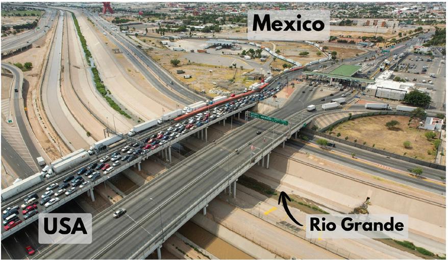
EXAMPLE 1: USA vs Mexico - The Chamizal Dispute: Meander Migration on the Rio Grande
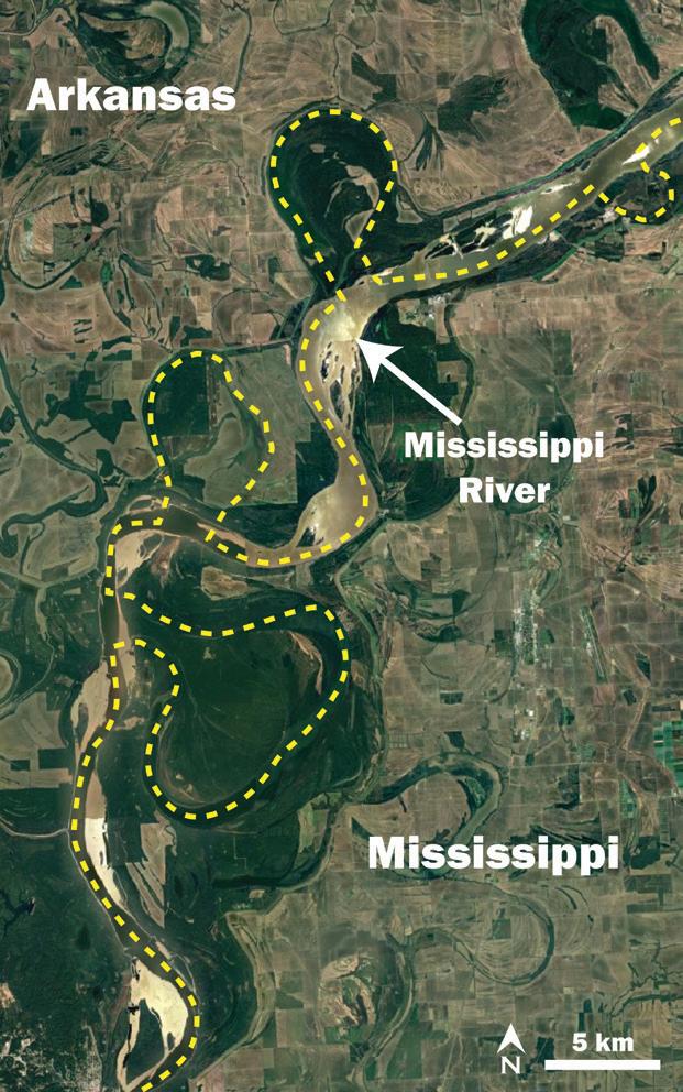
Meandering rivers pose particular challenges for geopolitical boundaries. The Mississippi River in the United States provides an example of how fluvial processes can reshape a channel, leaving political enclaves stranded on the opposite side of a river (Figure 1). In this instance, these are friendly state boundaries within a single sovereign nation. When similar processes occur along international borders, however, the stakes are far higher.
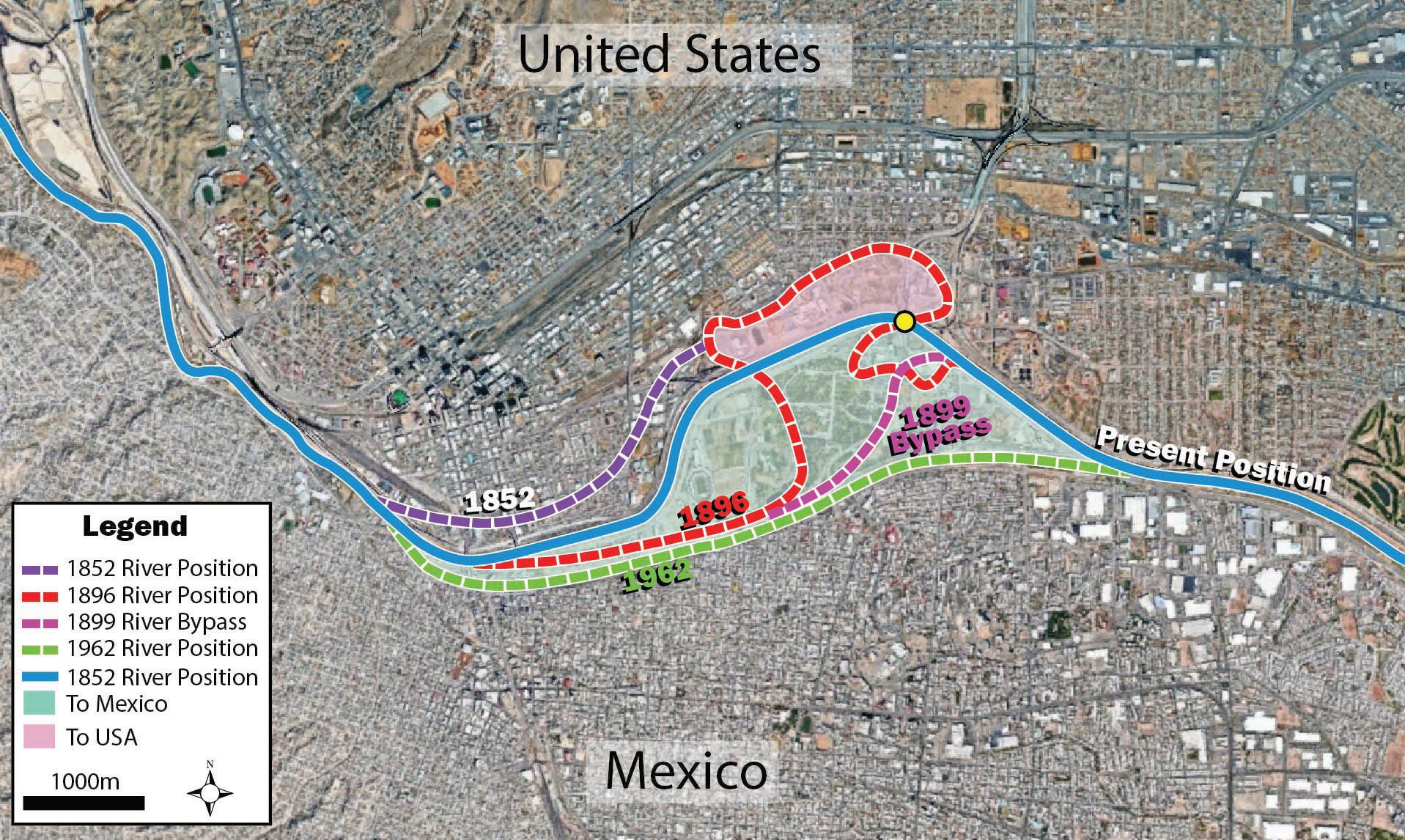
This was the situation along the Rio Grande at the border between the United States and Mexico, specifically between the cities of El Paso, Texas, and Ciudad Juárez. Figure 2 shows the position of the Rio Grande as surveyed in different periods of time. Significant floods in 1862, 1864, 1865 caused substantial shifts in the river’s course, effectively transferring land from Mexico to the United States and leaving many Mexican residents abruptly residing on the U.S. side of the border (Sears, 2023).
Subsequently, the river developed a pronounced meander bend that pushed the channel northward (Figure 2), encroaching into United States territory, with the inner portion of the resulting point bar situated on the Mexican side of the river. Both countries participated in excavating a channel across the heel of the meander bend, creating a man-made avulsion for flood control purposes. Under international law, only gradual channel migration caused by natural erosion and deposition of the riverbanks can shift a riverine border, while avulsions (including those produced by human engineering) do not (Prescott & Triggs, 2008; National Park Service, n.d.). Since the 1899 cutoff was an artificial diversion rather than a naturally evolving meander shift, the newly established channel did not redefine the boundary, and the pointbar surface remained Mexican territory despite the river occupying a new course.
LAYCOCK, ERIN PEMBERTON, PAUL BREMNER, SEAN FLETCHER, HAN BYUL WOO, RICHARD MACKENZIE
Figure 1:
Annotated Google Earth image showing the Mississippi River between Mississippi and Arkansas, and how the border (yellow dashed line) no longer follows the current path of the river.
Figure 3: Image of the border between Mexico and the USA at the Bridge of the Americas, looking southward into Mexico. The banks of the Rio Grande in this location are reinforced with concrete to prevent further migration of the channel. Image courtesy of U.S. Customs and Border Protection.
Figure 2:
Annotated Google Earth image of the Rio Grande at El Paso, Texas and Ciudad Juarez, Mexico. Shows the changing position of the river through time, and how that affected the territory of each nation.
Tensions related to the Chamizal dispute were already high when U.S. President William Howard Taft and Mexican President Porfirio Díaz met at the El Paso and Ciudad Juárez summit on October 16, 1909. Security for the summit was extensive, involving the Texas Rangers, U.S. Secret Service agents, federal officers, U.S. Marshals, and approximately 4,000 combined U.S. and Mexican troops (Harris & Sadler, 2009). During the event, a Texas Ranger discovered an individual armed with a pistol who intended to assassinate both presidents (Harris & Sadler, 2009). The dispute remained unresolved for decades until its peaceful settlement under Presidents John F. Kennedy and Adolfo López Mateos at the 1963 Chamizal Convention, where they agreed to restore the disputed tract to Mexico and stabilized the Rio Grande floodplain through engineered channel rectification, as shown in Figure 3 (U.S. Department of State, 1964).
EXAMPLE 2: China vs Russia - The Ussuri River and the Battle for Zhenbao (Damansky) Island
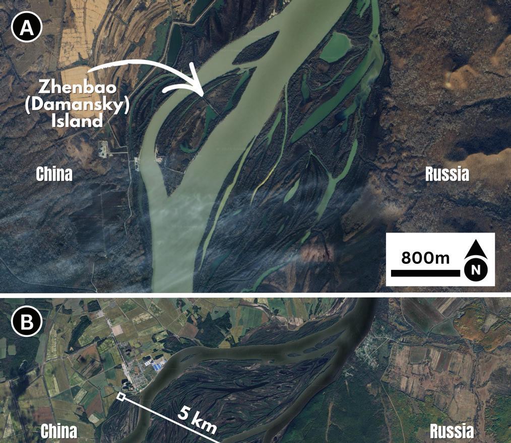
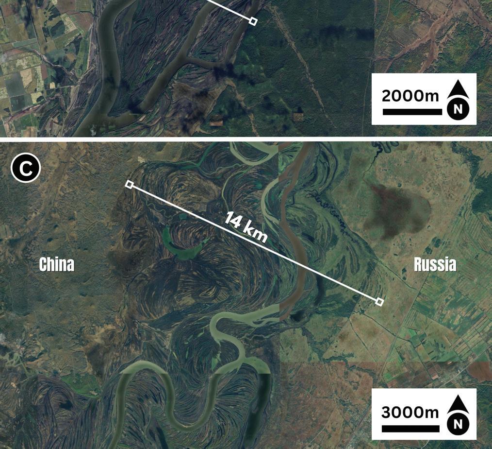
The Chamizal dispute illustrates how dynamic fluvial processes can create international tensions, but disputes become even more complex when neighboring states cannot agree how a river boundary itself should be defined. This was the case for Zhenbao (Damansky) Island on the Ussuri River, contested by China and Russia. At this location, the Ussuri River transitions from a single-thread channel to a multi-thread system, creating a mid-channel bar referred to as Zhenbao Island by China, and Damansky Island by Russia. This mid-channel bar or ‘island’, is approximately 1.2 kilometers long and 0.6 kilometers wide at its widest point (Figure 4), yet it became the focal point of a dispute that resulted in dozens of casualties.
Satellite imagery shows that in this region, the Ussuri River actively constructs large bar complexes with welldeveloped scroll patterns, reflecting actively accreting mid channel bars, and frequent transitions between singlethread and multi-thread channels (Figure 4). Upstream and downstream of Zhenbao (Damansky) Island the channel belt expands up to 14 km wide, locally containing numerous mid-channel islands. In such a complex and dynamic environment, defining a stable and unambiguous international boundary is inherently difficult. Although many similar mid-channel bars or ‘islands’ exist, this particular feature became symbolically important as a test case for broader disagreements over boundary definition. The origins of the dispute lie in 19th century treaties between the Russian Empire and the Qing Dynasty, specifically with the treaties of Aigun (1858) and Bejing (1860). The Russians were able to leverage the Qing Dynasty into giving up territory, including the entirety of the Ussuri River, claiming all mid-channel islands as their territory (Vuving, 2020). By the 1950s, the Chinese government challenged the legitimacy of these “unequal treaties” and advocated for the application of international law conventions, which generally define riverine borders along the thalweg of the channel. Under this interpretation, many of these mid-channel islands, including Zhenbao (Damansky) Island, would fall back within Chinese territory (Maxwell, 2005).
On March 2, 1969, Chinese troops ambushed a Soviet border patrol on Zhenbao (Damansky) Island, triggering a battle that lasted several weeks and became part of the broader Sino-Soviet border conflict (Center for Naval Analyses, 2010). Although active fighting eventually ceased, tensions persisted for decades and were not fully resolved until the late twentieth and early twenty-first centuries.
Figure 4: Google Earth satellite images of the Ussuri River. A) Zhenbao (Damansky) Island located on the Ussuri River. The modern border between China and Russia follows the thalweg, placing the island in China, but was previously claimed by Russia. B) Shows another part of the Ussuri River located to the north of Zhenbao (Damansky) Island, where the river once again splits from single thread to multi-thread, creating additional mid-channel island bars. Also visible are large meander scroll patterns, and the overall channel belt widens to ~5 km. C) Another location on the Ussuri River located to the south of Zhenbao (Damansky) Island. Visible in this image are large meander scroll patterns, multiple oxbow lakes, mid-channel island bars, and the overall channel belt expands to ~14 km.
EXAMPLE 3: India vs Pakistan - Siachen Glacier Conflict
While the previous examples focus on riverine borders, disputes over rivers of ice can be equally consequential. The Siachen Glacier, located along the contested border between India and Pakistan, is the second longest glacier in the world outside the polar regions, and hosts the highest altitude battlefield in recorded history (Baghel & Nüsser, 2015).
Situated on the eastern Karakoram Range, it forms one of the world’s most extreme geopolitical frontiers where control has been contested since the mid-twentieth century.
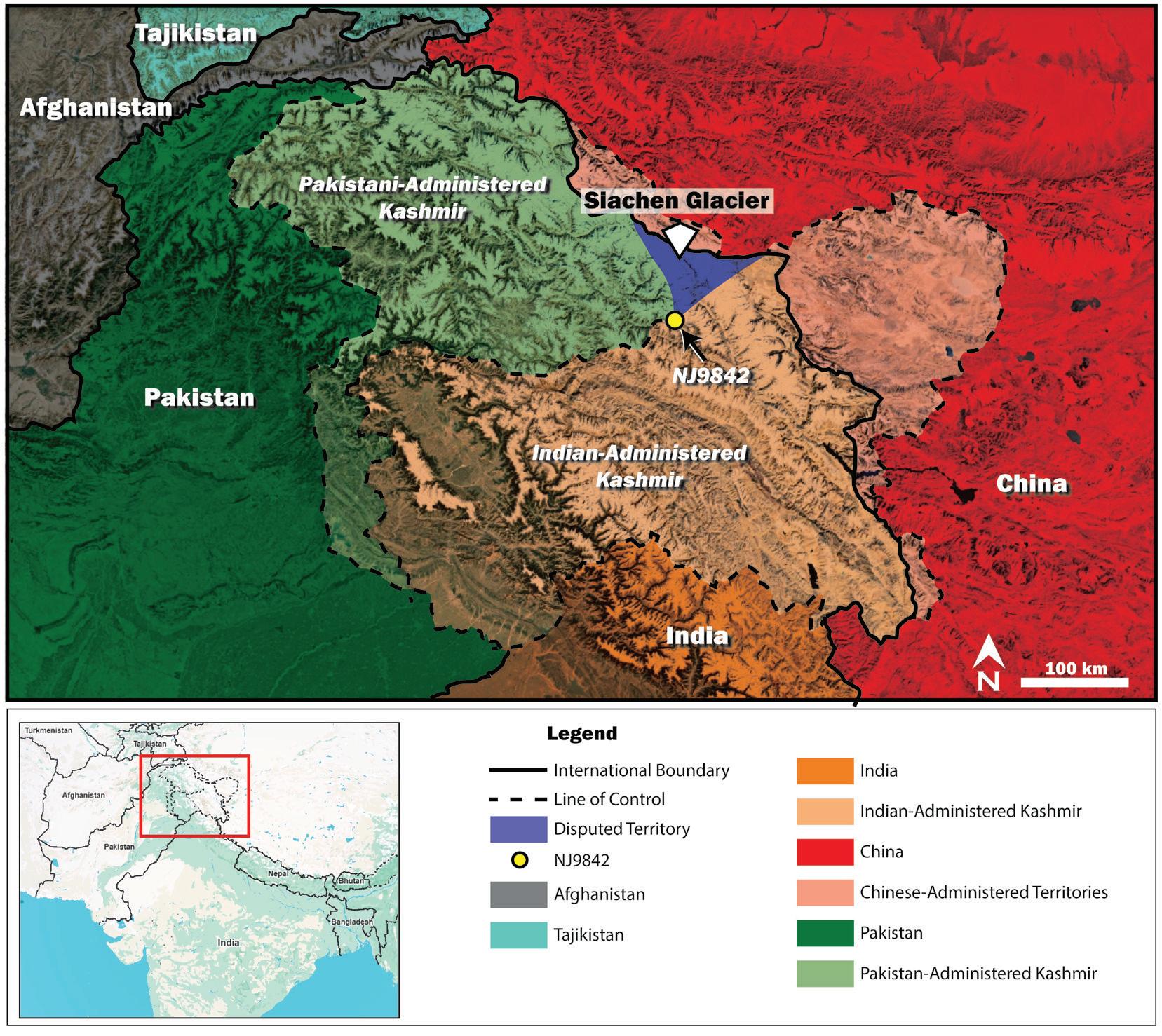
The dispute likely has its origins in the wording of the original territorial agreement between the countries. The 1949 Karachi Agreement established a ceasefire line at the end of the first Indo-Pakistan war. At the time of the agreement, the high-altitude Karakoram Range region was poorly mapped and not well understood. As such, the boundary was mapped in detail up to a map coordinate called “NJ9842” (Figure 5), beyond which the text states the boundary would continue “thence north to the glaciers”. Given the presence of multiple glaciers north of point NJ9842, with a complex network of glaciers, mountains, and drainage networks, the intended boundary remained unclear. Pakistan favored a straight-line projection, while India advocated for a geographic approach, following topographic divides and ridgelines to delineate the border, placing geology and geomorphology at the center of the dispute.
The Siachen Glacier is surrounded by extreme topography, a product of the ongoing collision and convergence of the Indian and Eurasian
Figure 5: Annotated Google Earth image showing the region surrounding the contested Siachen Glacier. Solid lines represent recognized international borders between India, Pakistan, Afghanistan, Tajikistan, and China. Dashed lines indicate lines of control within contested areas. The purple region north of NJ9842 is the disputed region. Inset shows a Google Earth image of the surrounding region for context.
plates, creating high strength crystalline rocks, rapid uplift, and extensive glaciation (Owen & Dortch, 2014). Dominant rock types in the eastern Karakoram Range include orthogneiss, paragneiss, schist, amphibolite, and granitoid intrusions formed coeval with Cenozoic crustal thickening and partial melting (Weinberg et al., 2000; Searle et al., 2011). Structural deformation of the area reflects both crustal shortening and strike-slip motion related to the Karakoram Fault System to the east, providing large contrasts in uplift and erosion rates throughout the area (Searle and Phillips, 2008; Wallis et al., 2009). These processes produce extreme topography, with sharp ridgelines rising abruptly above glacial surfaces and creating natural defensive positions.
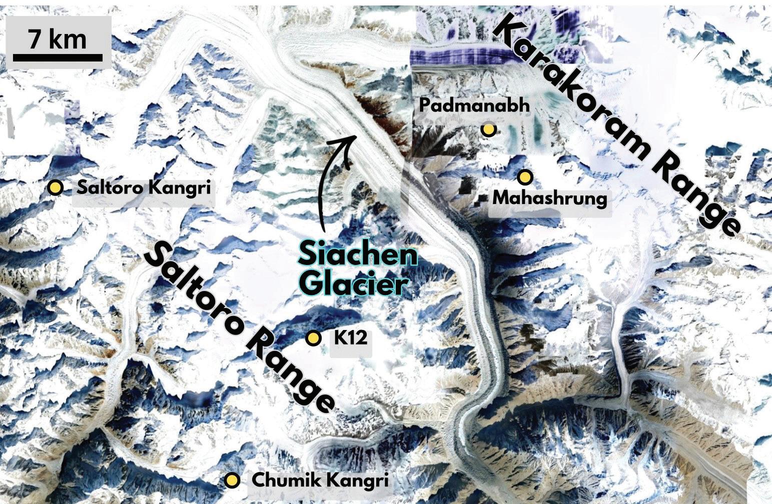
The Siachen Glacier itself is located between the Saltoro Mountains to the southwest and the Karakoram Mountains to the northeast (Figure 6). The Saltoro Ridge forms the southwestern boundary of the Siachen glacial system, and serves as the drainage divide between the Siachen glacier, which flows to the southeast, and the smaller Bilafond La, Gyong La, and Chumar glaciers that flow to the southwest. Since Operation Meghdoot in 1984, Indian forces have controlled the Saltoro Ridge, and adjacent glaciers to the south of the ridge. Pakistan has positions located to the west of Saltoro Ridge, at lower elevations across the valley. Control of the high ground gives India a strategic advantage in the ongoing dispute.
This conflict has remained largely static since the mid 1980’s, with the rough terrain making progress for either side difficult. The extreme elevation, steep slopes, limited approach routes, and glacial crevasses severely constrain military operations. As a result, a third combatant emerged in this conflict: Mother Nature. The extreme natural conditions have claimed far more casualties than direct combat or enemy bullets. Since 1984, India has reported around 220 deaths from enemy engagement, compared with over 800 deaths from environmental conditions, such as altitude sickness, avalanches, crevasse falls, and extreme cold. Pakistan reports more than 200 similar environmental casualties with only 30-40 combat related fatalities.
The Siachen Glacier conflict demonstrates how geology and geomorphology can directly shape geopolitics. The extreme terrain creates strong defensible positions of high ground, terrain that limits movement, and mountain ranges and glaciers that divide regions. Regardless of the political stalemate, the environment continues to exert its influence imposing a heavy toll on both sides.
Figure 6: Annotated Google Earth image of the Siachen Glacier. Visible are lateral moraines and the terminal moraine, as it transitions southward into the Nubra River. Yellow dots indicate prominent mountain peaks in the region. Annotated is the Saltoro Range to the southwest and the Karakoram Range to the northeast of Siachen Glacier.
EXAMPLE 4: Canada vs Denmark - Hans Island and the Whiskey War
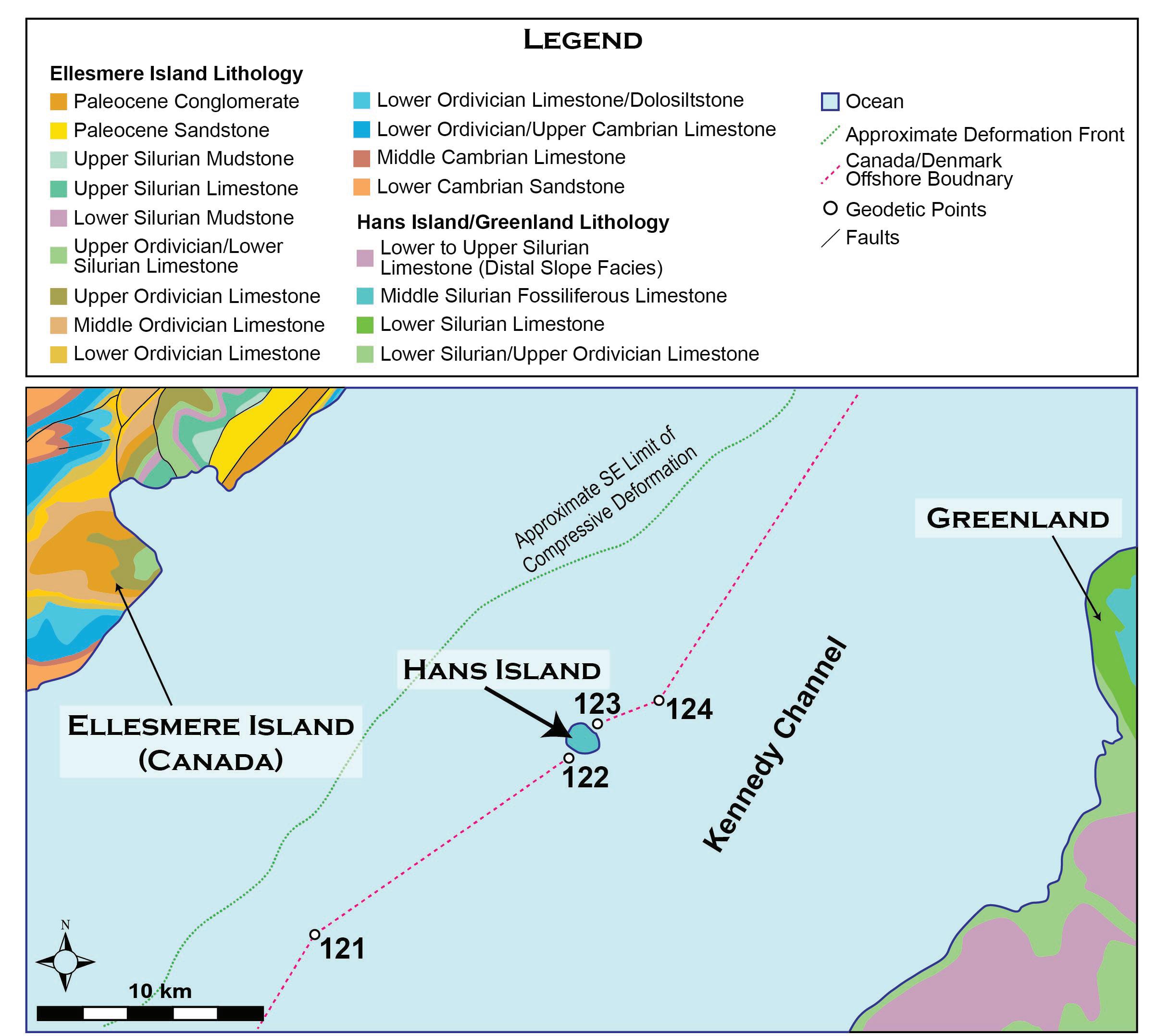
One of the most unusual borders, as well as border disputes, involved Canada and Denmark on a small uninhabited island, Hans Island, in the Kennedy Channel of the Arctic’s Nares Strait, between Greenland and Ellesmere Island. Hans Island lies within gently dipping strata of the Arctic Platform, adjacent to the Central Ellesmere Fold Belt on Ellesmere Island to the northwest (Figure 7; Harrison et al., 2007).
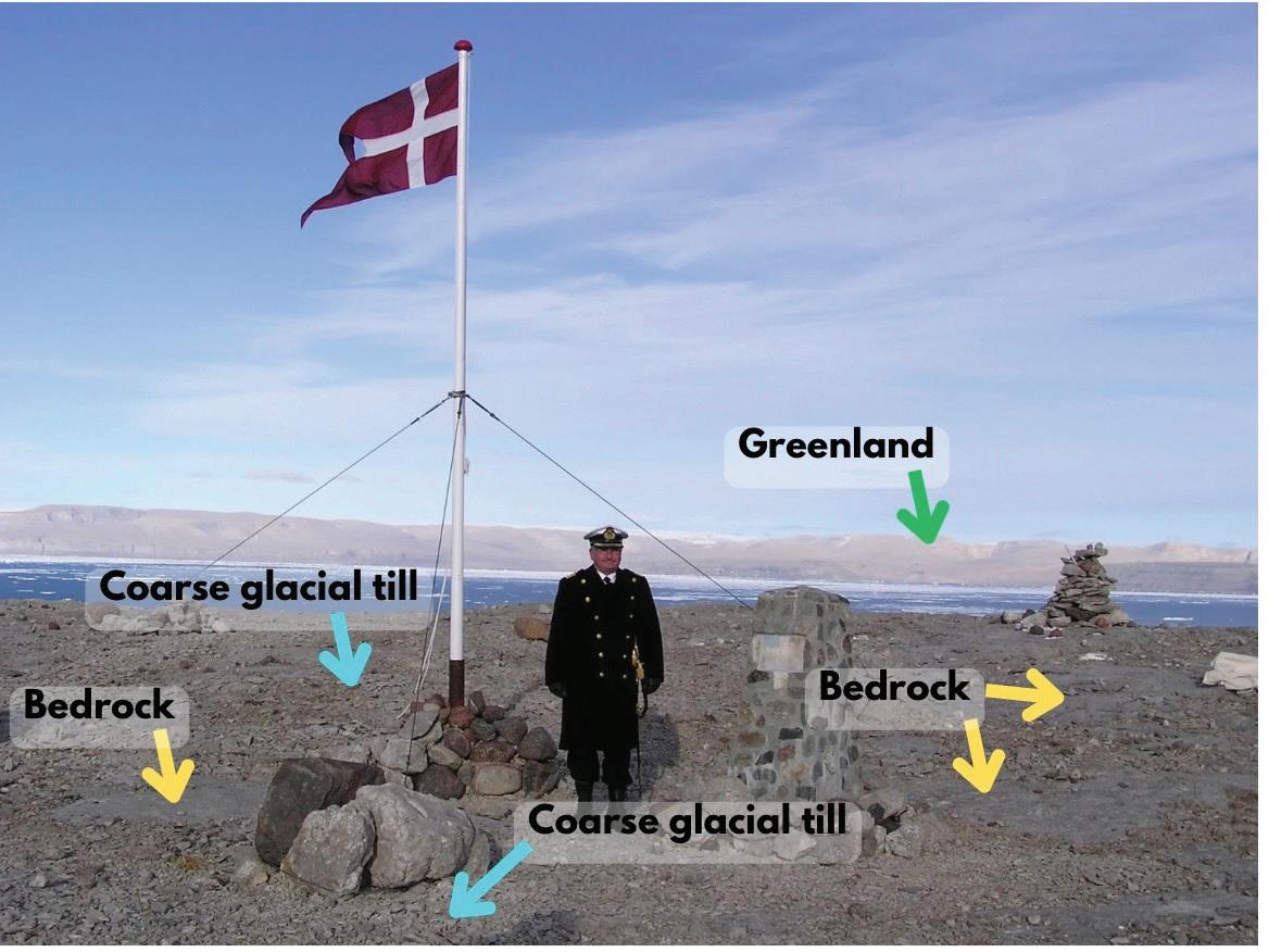
The floor of the Kennedy Channel consists of glacially sculpted limestone bedrock punctuated by topographic highs, some of which are exposed above sea level (Harrison et al., 2007). Hans Island is one such exposure, with bedrock composed primarily of fossiliferous Silurian limestone and thin veneers of glacial till (Figures 8 and 9; Harrison et al., 2007). In publicly available field photos, the glacial till appears to be coarse grained, with patchy coverage of the surface of the island (Figure 9).
A 1973 boundary agreement between Denmark and Canada established a maritime border through the Nares Strait using a series of geodetic points (Figure 7; Kingdom of Denmark & Canada, 1973). The sequence conspicuously omitted Hans Island, reflecting the absence of the consensus of sovereignty at the time. Despite this omission, both countries continued to assert sovereignty over the island (Parliament of Canada, 2017).
CONCLUSION:
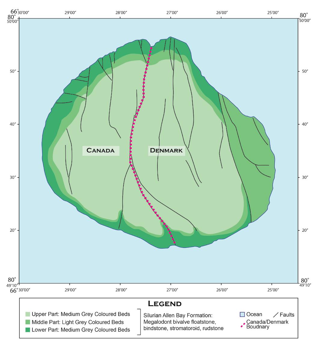
Geologically, Hans Island bears more geologic similarities to Greenland than it does to Ellesmere Island. As seen in Figure 7, Ellesmere Island displays a variety of highly faulted and folded strata, as it is within the Central Ellesmere Fold Belt. The eastern limit of compressive deformation is located offshore of Ellesmere Island, beyond which is the gently dipping arctic platform (Harrison et al., 2007). Accordingly, gently dipping Silurian limestone of Hans Island then more closely resembles the geological signature of Greenland. Fortunately for Canada, the geologic similarities appear to not have been a contributing factor to resolving this border dispute. However, the geology did factor into the location of the border itself.
In 2022, Canada and the Kingdom of Denmark reached a final agreement resolving the dispute (Global Affairs Canada, 2022). Rather than arbitrarily dividing the island, negotiators chose to follow a prominent, deeply weathered fracture that trends roughly north-south across the island (Figure 8). This structural lineament reflects the regional tectonic stress regime of the Kennedy Channel (Harrison et al., 2007). The result is a linear boundary aligned with an observable geologic feature rather than an arbitrary cartographic compromise, allowing structural geology to play a direct role in peacefully resolving a nearly fifty-year-old geopolitical dispute.
These case studies demonstrate that geology is not merely a backdrop to geopolitical boundaries, but an active agent in shaping them. These examples show how choosing nonstatic geologic features have led to conflict because rivers migrate, glaciers flow, and mountains rise, often in ways that are incompatible with the fixed lines of political maps. The Chamizal and Zhenbo Island disputes highlight how dynamic fluvial systems complicate the application of legal boundaries, particularly where channel migration, avulsion and thalweg interpretation intersect with national sovereignty. The Siachen Glacier conflict shows how tectonically driven topography and glaciation create extreme, defensible landscapes that can freeze geopolitical disputes in place while imposing severe human and environmental costs. In contrast, the resolution of the Hans Island dispute illustrates how observable geologic structures can be leveraged to peacefully settle longstanding boundary disagreements. Together, these examples underscore a common theme: when political borders (no matter how small!) are tied to evolving Earth systems, successful boundary definition and conflict resolution depends on an informed understanding of geological processes and their long-term behaviour.
Figure 7: Geologic map of the region surrounding Hans Island. Shows the flat-lying strata of Greenland to the east, contrasted with the contorted lithologies of Ellesmere Island to the west. Also shown are the geodetic points extending from either side of Hans Island, indicating the previous lack of definition on the island’s territorial rights. Modified from Harrison et al., 2007.
Commander
of
Grade Per
Danish patrol ship HDMS
on Hans Island in August 2003. Patchy coverage of glacial till can be seen in the foreground, along with exposed patches of bedrock. The gently dipping strata of Greenland can also be seen in the background. Image courtesy of By Per Starklint (CC BY-SA 4.0, https:// commons.wikimedia.org/w/index.php?curid=87885798).
Figure 9: Image of
Senior
Starklint, captain
the
Triton,
Figure 8: Zoomed in geologic map isolating Hans Island, modified from Harrison et al., 2007.
REFERENCES AND SUGGESTED READINGS:
Baghel, R., & Nüsser, M. (2015). Securing the heights: The vertical dimension of the Siachen conflict between India and Pakistan in the Eastern Karakoram. Political Geography, 48, 24–36. https://doi. org/10.1016/j.polgeo.2015.05.001
Center for Naval Analyses. (2010). The Sino Soviet border conflict of 1969. CNA Analysis and Solutions. https://www.cna.org/reports/2010/ d0022974.a2.pdf
Government of India & Government of Pakistan. (1972). Agreement on bilateral relations between the Government of India and the Government of Pakistan (Simla Agreement).
Harrison, J. C., Dewing, K. E., & Mayr, U. (2007). Geology of Hans Island and adjacent parts of Kennedy Channel, northwest Greenland (Kalaallit Nunaat) and northern Nunavut (Canada) (Geological Survey of Canada, Open File 5321, 52 p.). Natural Resources Canada. https://doi. org/10.4095/224255
Harris, C. H., III, & Sadler, L. R. (2009). The secret war in El Paso: Mexican revolutionary intrigue, 1906–1920. University of New Mexico Press. Kingdom of Denmark & Canada. (1973). Agreement between the Kingdom of Denmark and Canada relating to the delimitation of the continental shelf between Greenland and Canada (UNTS No. 13550). United Nations Treaty Series.
Maxwell, N. (2005). How the Sino Russian boundary conflict was finally settled. Hokkaido University Center for Northeast Asian Studies. https:// src-h.slav.hokudai.ac.jp/coe21/publish/no16_2_ses/02_maxwell.pdf
National Park Service. (n.d.). 1910 Chamizal Arbitration Treaty. U.S. Department of the Interior. https://home.nps.gov/cham/learn/ historyculture/1910treaty.htm
Owen, L. A., & Dortch, J. M. (2014). Nature and timing of Quaternary glaciation in the Himalayan–Tibetan orogen. Quaternary Science Reviews, 88, 14–54. https://doi.org/10.1016/j.quascirev.2013.11.016
Owen, L. A., Finkel, R. C., Caffee, M. W., & Gualtieri, L. (2002). Timing of multiple glaciations during the late Quaternary in the Hunza Valley, Karakoram Mountains, northern Pakistan. Geological Society of America Bulletin, 114(5), 593–604. https://doi.org/10.1130/00167606(2002)114<0593:TOMGDT>2.0.CO;2
Parliament of Canada. (2017). Hans Island: Delimitation of the Canada–Denmark boundary in Nares Strait (Publication No. YM32-9/08-05). Government of Canada.
Phillips, R. J., Searle, M. P., Parrish, R. R., & Waters, D. J. (2008). Geological map of the Karakoram Fault zone, eastern Karakoram, Ladakh, NW Himalaya. Journal of the Virtual Explorer, 4(1), 21–37.
Sears, S. (2023). Beyond the river’s violence: Reconsidering the Chamizal border dispute. Diplomatic History, 47(3), 419–445. https://doi. org/10.1093/dh/dhad020
U.S. Department of State. (1964). The Chamizal settlement: Agreement between the United States and Mexico. Government Printing Office. United Nations Commission for India and Pakistan. (1949). Karachi Agreement. United Nations.
Vuving, A. (2020). China and the unequal treaties. In China foreign relations (pp. 63–84). Vietnam Institute for Foreign Relations. https:// vifdatabase.com/wp-content/uploads/2020/09/Foreign-Relations.pdf
James (Jim) Barclay 2025 HONORARY MEMBERSHIP AWARD
CEGA welcomes James (Jim) Barclay into Honorary Membership of the society in recognition of his many contributions to petroleum exploration and evaluation as well as his many volunteer activities with our society and the petroleum industry. Jim has always been greatly respected for his dedicated effort to the task at hand, his generous spirit, and for being the type section of a team player.
Jim was born in 1952 and began his geological career in 1976 after his completion of a Bachelor of Science from Carleton University. His first three years were spent in mineral exploration throughout Canada. In 1979, with oil prices rocketing upwards, he arrived in Calgary and joined Dome Petroleum. He remained with Dome for five years, exploring for petroleum in diverse geological settings, including the Peace River Arch, the Foothills, the Deep Basin, and the Beaufort Sea.
In 1984, he joined the Calgary office of the Geological Survey of Canada and spent the next ten years in the petroleum assessment subdivision. In this capacity he conducted detailed studies of petroleum reservoirs in the Western Canadian Sedimentary Basin and provided resource assessments based on regional basin analysis. During this
decade he published numerous important articles with his Geological Survey of Canada co-workers, including four chapters in the Geological Atlas of Western Canada, and numerous detailed resource assessments. He also gave many conference presentations on his wide-ranging and insightful studies.
In 1989, in his “spare time”, he began work on obtaining a doctoral degree at the University of Calgary under the guidance of Fed Krause. He received his PhD in 2000, and his thesis involved groundbreaking research on the Late Paleozoic stratigraphy and structure of the Peace River Arch/Embayment, a prolific petroleum province. His thesis won the CSPG PhD Award in 2001, and his publications emanating from this work are still consulted by those exploring the Arch.
In 1994, he returned to the “Patch,” and for the next twenty-two years was a highly successful explorationist being involved in numerous oil and gas discoveries in the Western Canadian Sedimentary Basin. He worked for start-up, junior, intermediate, and multi-national companies and his positions included senior geologist, chief geologist and Vice President Exploration. He spent the last twelve years of his career at Burlington and ConocoPhillips, where he
especially enjoyed his role as a teacher and mentor to younger staff members.
Jim joined the CSPG/CEGA in 1983 and has been an enthusiastic volunteer in numerous capacities. His most notable contribution has been his participation on the executive committee, where he has served as a director at three different times (1996-1997, 2010-2012, 2017-2018). He also has been involved in the annual Core Conference, both as a presenter and an organizer. Other notable volunteer positions include technical program chair of the 75th anniversary convention in 2002, member and chair of the Medal of Merit committee (19972006), member stratigraphic nomenclature committee (1991-present) and an associate editor of the Bulletin (2005-2007). For his dedicated volunteerism, Jim has received the H.M. Hunter Award (2020), and President’s Award (2024), as well as Service Awards (2005 & 2015), and a Volunteer Award (2003).
Jim’s distinguished career as a petroleum geologist, combined with his devoted service as a CEGA volunteer, makes him a most deserving recipient of honorary membership.
Platinum and Pythons
JON NOAD | STANTEC CONSULTING; ADELAIDE UNIVERSITY
INTRODUCTION (LATE 1980S)
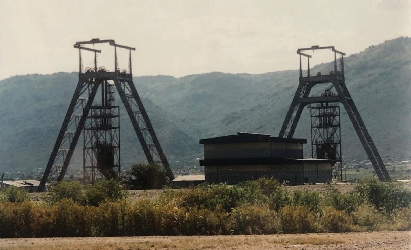
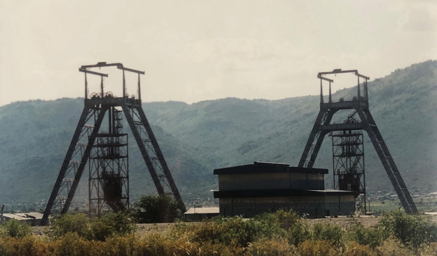
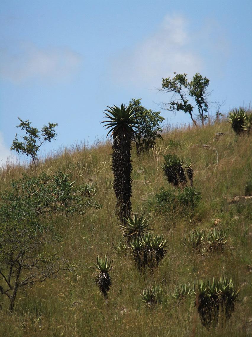
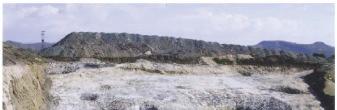
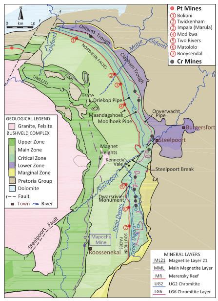
I lay in bed, listening to the relentless beating drums in the distance. It felt like a lifetime away from rainy London. When I had accepted the job of geologist on a brand new, shaft sinking platinum mine, I hadn’t been prepared for the true wildness of the region. Driving to my new workplace through the Steelpoort River Valley (Figure B3), tracing the path of an enormous fault, I could see occasional mine headgears amongst the giant lobelias (Figures 1 and 2). The countryside was barren and mountainous, classic “bushveld” country. The slopes were rocky, with a distinctive ochre colouration. As I neared the mine that was to become a big part of my life, Kennedy’s Vale, I was transfixed by a huge, steep sided, conical hill looming over the site.
Kennedy’s Vale Mine (originally known as Rhodium Reefs due to the relatively high rhodium concentrations in its ore) is located in Limpopo Province, formerly Eastern Transvaal in South Africa, some 300 km east of Johannesburg (Figure B3). I had driven up from Welkom in the Free State, leaving behind a life at St Helena Gold Mine, employing 30,000 people, to join an “in progress” platinum mine with a handful of staff and a few drilling contractors. I ended up spending nearly two years in this remote outpost (Figure 3), where the nearest supermarket was more than an hour away. Just to the North, across the Steelpoort River, lay Sekhukhuneland (once part of the Lebowa homeland), a region in dire need of financial assistance from a government that seemed to have other priorities. To the east was the increasingly mountainous terrain of the Highveld, with the jewel of Kruger National Park at its heart.
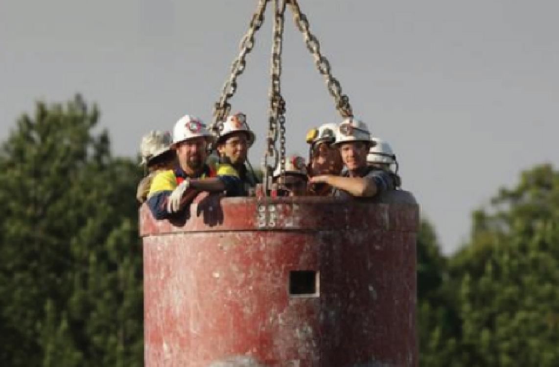
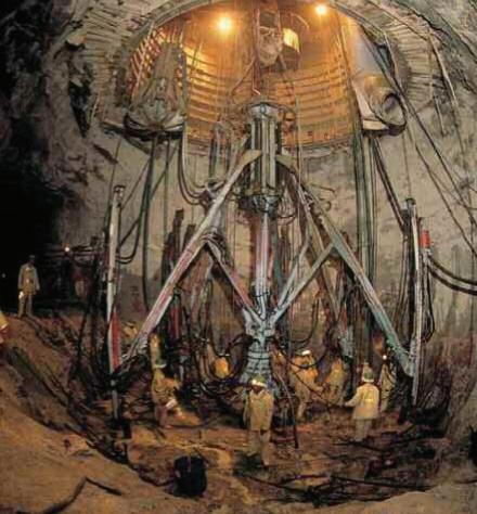
My new role in Steelpoort was as the Mine Geologist, with several key jobs to address. I was responsible for monitoring the geology encountered in the twin shafts of a new platinum mine (Figure 1), deepening daily; an open cast vanadium mine (Figures 4 and 5); and the world’s largest chromitite mine. Every other day I had to get into my boots, overalls and hard hat with lamp attached, climb into a large metal bucket known as a kibble (Figure 6), and be lowered around 800 metres into the shaft-sinking mine. Everyone feared the occasional “trips”, when power tripped out for a moment, and the kibble dropped a few feet.
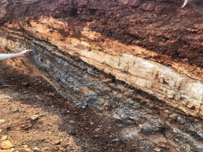
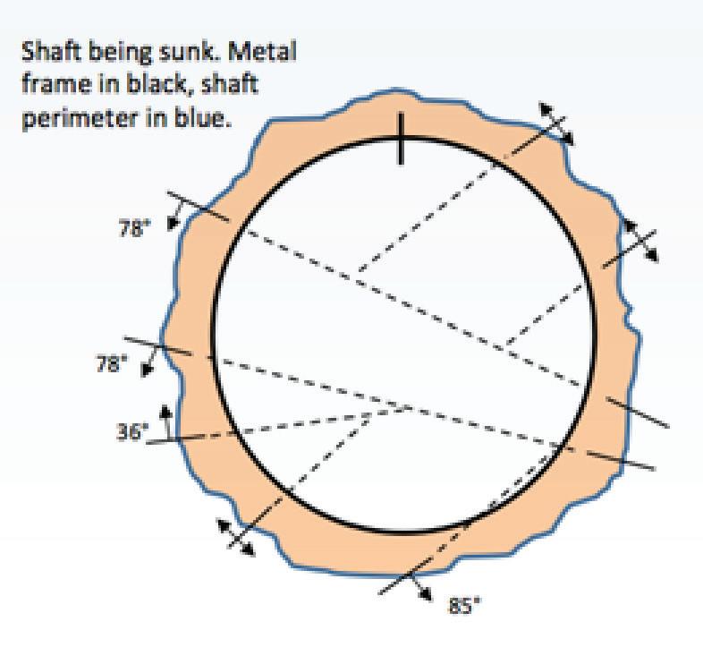
Once at shaft bottom (Figure 7), I had to make my way around the drilling gear, which loomed like some malevolent ogre in the shaft. The diameter of the shaft was 8.9 m, and I had to work my way around it measuring faults and fractures (Figure 8) that might affect the shaft integrity. I also had to log the stratigraphy of the shaft, measuring the layers of rock which had formed some 2000 million years before, crystallising out from magma in a series of thirteen subterranean chambers, each tens of kilometres across (see “Geology of the Bushveld Complex” below). Incredibly the rock was still hot to the touch underground, because of residual heat from the magma as it cooled, beginning billions of years before. There were a variety of igneous rocks ranging from pegmatites made up of large
Figure 3. Typical Bushveld scenery east of Burgersfort
Figure 4: Steelpoortdrift vanadium project, where mineralization occurs within four titano-magnetite-rich layers (photo from Vanadium Resources)
Figure 2. Lobellias close to Kennedy’s Vale Mine
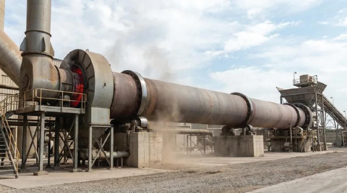
Figure 5. Rotary kiln similar to the one used at Vansa Vanadium (Kintek Solutions)
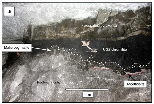
Figure 9. UG2 reef exposed underground at Modikwa Mine, South Africa (Mungall et al 2016)
Figure 6. Kibble in action (urbancrows.com)
Figure7. Drilling equipment at shaft bottom (Evans and Graham 2020)
Figure 8. Fracture mapping at Kennedy’s Vale Mine
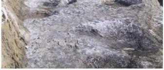
crystals, pale norites and anorthosites, the latter a white rock with black snowflakes throughout. Then there were basalt-like gabbros, usually a dull grey in colour, and finally there were jet black chromitites (Figure 9).
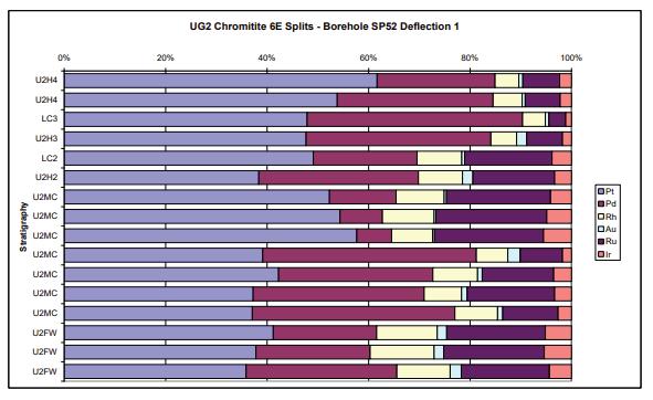
Chromitite made our world go round. These rocks formed layers from millimetres to metres in thickness, which could be traced for hundreds of kilometres. The chromitite was processed to produce chrome, but also contained platinum group metals such as platinum, palladium and rhodium (Figure 10). Its coarse texture and high density had led to acres of chromitite foundering into the underlying norites back when the rocks were still molten, forming “potholes” (Figure 11). Mapping out these structures was another one of my responsibilities. As the tunnels advanced along the seams of chromitite I mapped the layers out, plotting up faults and dykes that broke up the layers (Figure 12).
Sometimes an enormous, wheeled vehicle would roll by as I worked (Figure 13), having been lowered nose first down the shaft and then teased into the horizontal development tunnels. I often worked with the mine surveyor, who placed “pegs” in the hanging wall (the ceiling of the tunnel), which were then surveyed to provide reference points for us.
Sometimes we used water powered rock saws to take samples for assay. What I remember most is the relentless heat in the tunnels (with a virgin rock temperature of 52˚C), despite the overworked refrigeration system.
Figure 10. Ore values in the UG2 reef from Kennedy’s Vale Mine (Hall and Montpellier 2010)
Figure 11. Open pit mining of the UG2 chromitite layer at the Karee Mine, South Africa, showing well developed potholes (reproduced from Van der Merwe and Cawthorn 2005)
Figure 12. Sketch showing an example of microfaulting in the UG2 chromitite.
(https://dwarsriviermine.co.za)
EXPLORATION
Another responsibility was drilling exploration wells to delineate the area underground in which platinum could be found and extracted. The first step was to get permission from the Chief of the Lebowa bantustan (formerly homeland), which sometimes meant waiting for up to two days to be granted an audience. The well sites were in the back of beyond (Figure 14), usually at the end of an extremely rough road that we had to carve out using a bulldozer. An old driller, “Pottie” Potgeiter, a slightly crazy, bearded old Afrikaner, would drive his portable drilling rig into the site on the back of a specially adapted Mercedes truck. We needed water to lubricate the drill bit, and initially we would try drilling water wells close to apparent faults in the rock at surface. If this failed the next step was to contact the local witch doctor, who would come and divine a water source. They were surprisingly good at their job, and often asked for weird items to be provided, much like a rock star asking for blue M&M’s in the dressing room. The last resort would be to pipe water from a distant river. Once drilling commenced, I would visit periodically to go and view the core, often being brought up from more than a kilometre depth. I remember one unforgettable morning, arriving at the rig site as the sun rose, and seeing a herd of impalas drinking from the water pit. Once completed, we would hand the site over to the locals, who always appreciated a free water well.
WILDLIFE
There were many animals in the area. Sometimes in the winter months we would encounter kudus, with their long, spiralled horns, sleeping on the black asphalt warmed by the sun. Once we disturbed a ratel, a rare type of badger, as we drove home after a night at the local pub. Vervet monkeys were common, often stealing fruit from the lemon and avocado trees in my garden. One monkey developed a love for rock core and would watch as I measured the core and its layers of different rock types, laid out on trays in the sunshine. Judging his moment, he would carry out a lightning raid, grabbing some core and forcing me to chase him through the thorny bushveld to retrieve it. There were also the odd scorpions, who seemed to enjoy the cool folds of curtains, and would fall out when you drew them in the evenings.
14. Exploration well being drilled at Mototolo Mine, close to Kennedy’s Vale (Anglo American Platinum. 2023)
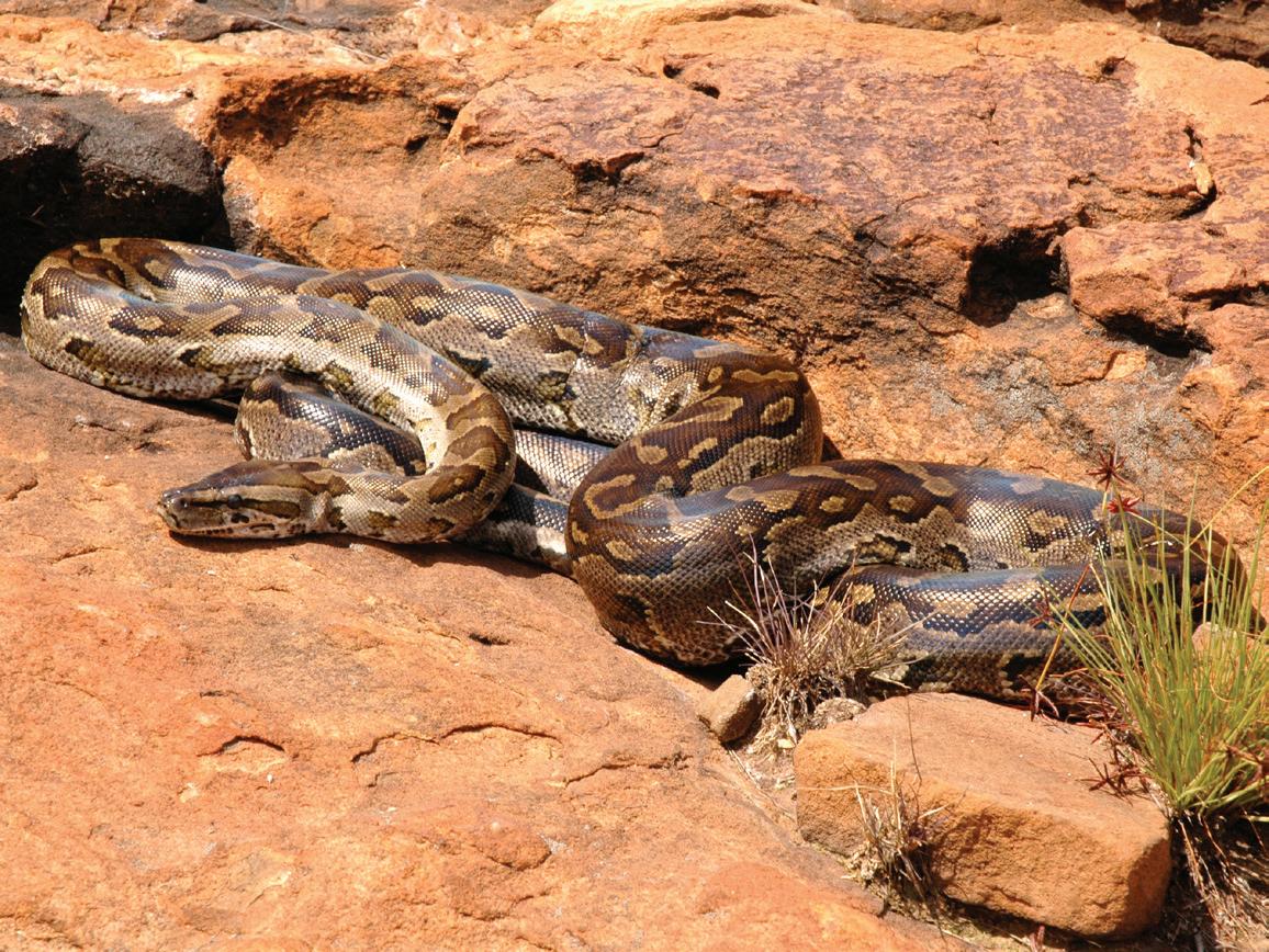
One day I was at work when the maid at the manager’s house called me in panic. The manager was away so I was looking after his place. I drove up to the house, perched near a mountain top among the boulders and there, lying by the pool, was an enormous python (Figure 15). It must have been close to eighteen feet in length and had a swelling partway down its body. This swelling, it turned out, was the manager’s dog, an unfortunate sheltie dog. We called in the local reptile expert, who captured the snake and transported it to safety. On the way they stopped at a children’s birthday party (the mine surveyor’s son had just turned eight) to show them the snake, and too much noise and prodding led the unfortunate snake to regurgitate the dog. A birthday to remember.
OTHER MINES
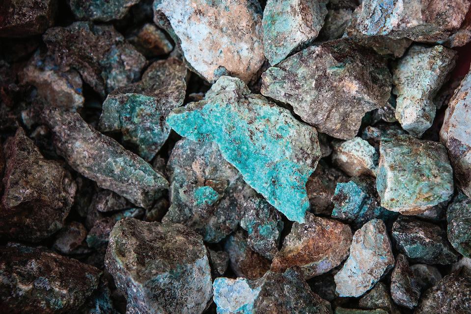
My responsibilities extended beyond Kennedy’s Vale to the local chromitite (Figure 16) and vanadium mines. The chromitite mine was, at the time, the largest in the world, and the vanadium one of the richest. My favourite feature of the chromitite mine was the use of chair lifts underground to transport the mine workers (including me) to the different levels. The best thing about the vanadium mine was a suite of rare, sulphur related minerals associated with the magnetite that hosted the vanadium. These were often brightly coloured, turquoise and lime green (Figure 17), and made very collectible samples.
All three mines were served socially by the “Club”, the Wintersveld Club, with a bar and meeting hall. We spent happy evenings drinking the local beer (Castle or Lion lager), and attending the monthly dances, which were dominated by “sokkie sokkie”, the Afrikaans version of the Two Step. But what a two step, with young men literally throwing their female partners over their shoulders, into the air and beyond, to a disco beat. Apparently in former times they used to coat the barn floors with sawdust for dances, and between songs everyone would jump up and hold on to the rafters while the floor was raked flat.
Figure 13. Loader in Dwarsrivier Mine
Figure
16: Bifurcating UG1 Chromitite seams within anorthosites at the Dwars River Provincial Heritage Site
Figure 15: South African Python (Graham Alexander, University of the Witwatersrand)
Figure
Figure
DRILLING MLALANE
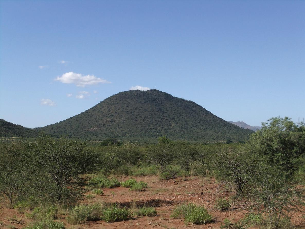
Some events stand out in my mind from my time in Steelpoort. We drilled an exploration well, looking for vanadium-rich magnetite, on top of the giant conical hill (Figure 18), known as Mlalane and sacred to the local tribes. We had to follow elaborate rituals before building the road, which spiralled up the hill like a children’s game. We had no fear of any equipment being stolen, as everyone stood in awe of the hill and its inhabitants. We used an army helicopter to lower the rig onto the hilltop, and our first sight of it was as it flew up the valley like a scene from the movie “Apocalypse Now”. The well was eventually drilled successfully to a depth of several hundred metres.
Another morning, we came into the mine office to telephones ringing off the hook. Something was up! A few words with my boss confirmed that the price of rhodium was going wild. A financier was trying to corner the entire world market in rhodium. Rhodium is the rarest metal to be produced in commercial quantities, and he had driven the price from around $2000/ounce to more than $7200/ounce in a matter of days. The UG2 “reef” (ore bearing chromitite) at Kennedy’s Vale Mine contained significant rhodium reserves, averaging around 0.7 g/t (Figure 10) and, for a brief period, our mine’s value tripled, before the predictable crash as the financier’s audacious move cratered.
VISITORS
Every now and again a party of geology students would come to visit us. They hailed from South African universities as well as from UK and US seats of learning. We put them up at my house, an old farmhouse acquired by Rand Mines along with its mineral rights. Some slept on the floors, others camped and we once managed to squeeze over forty students into the property. A hot day spent looking at outcropping rocks, perhaps spiced with a trip underground, would be followed by beers and a braai (South African BBQ), with honking great steaks and “pap and wors”, that is mealie meal porridge and sausage. We would sit around the fire telling stories and gaze up at the stars.
SUMMARY
Life in Steelpoort was an unforgettable experience, with a thrilling job in a unique setting. I was saddened when I eventually left the area for pastures new. Kennedy’s Vale mine was closed down at one time but has since been sold and is currently being re-evaluated to assess its potential commerciality. I have been back to Steelpoort a few times and things have changed. The sleepy community of Burgersfort is now a thriving hub, but the mine lies behind locked gates, and my former farmhouse was accidentally burned down by locals after the mine staff moved out. But the animals are still there, and as I passed through the valley, I caught a glimpse of a set of heads poking out of the long grass. They looked like dinosaurs, and I slammed on my brakes and watched as a flock of ground hornbills (Figure 19) marched out of the undergrowth. I will go to bed tonight and lie there imagining that, far in the distance, I can hear the faint sound of drums.
Figure 18. Mlalane, a conical hill drilled for vanadium. Note the spiral dirt road climbing the hill
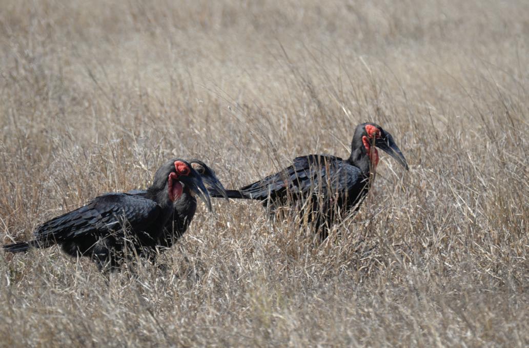
Figure 19. Hornbills
Geology of the Bushveld Complex
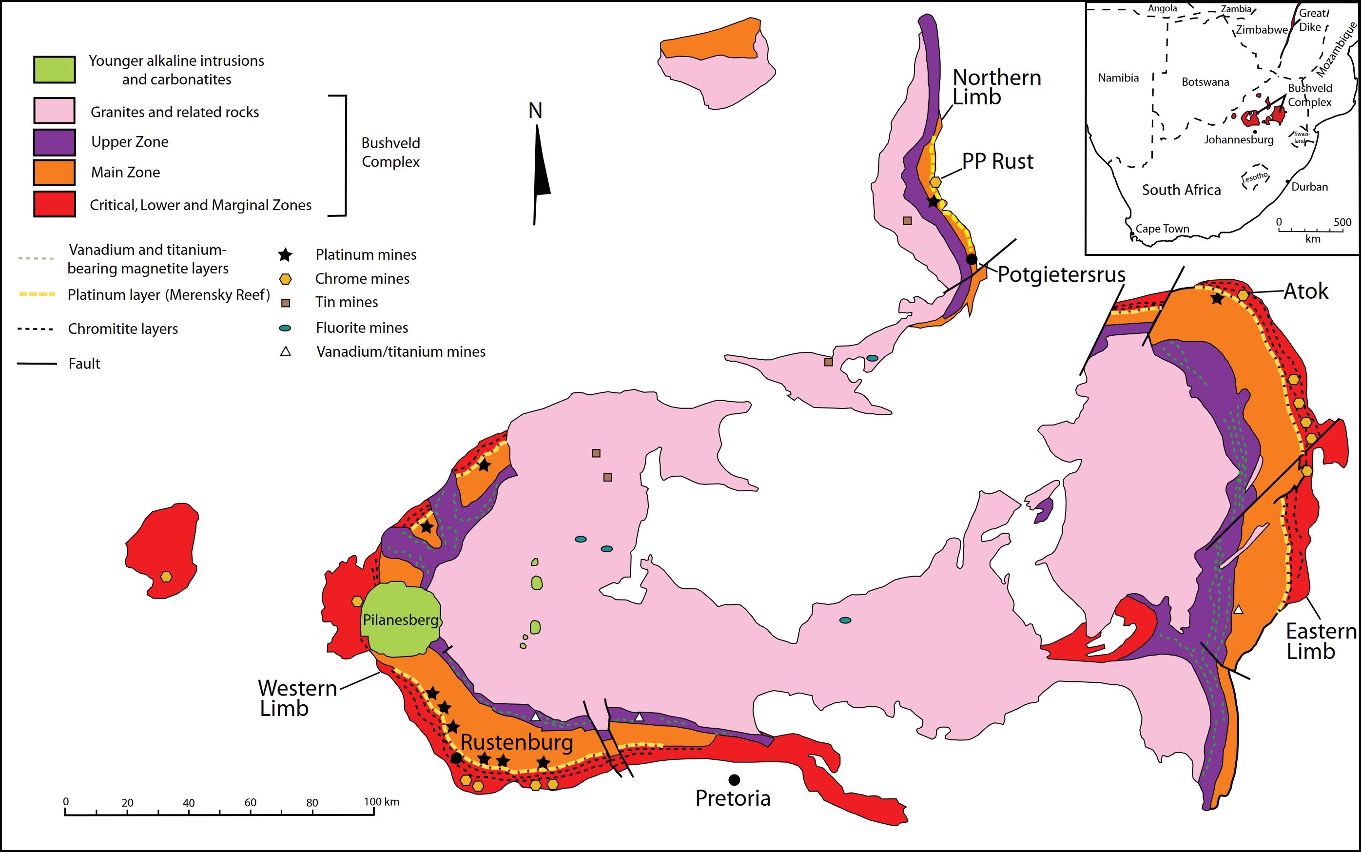
The Bushveld Complex is the world’s largest layered igneous body (Figure B1) and hosts the world’s greatest deposits of Platinum Group Elements (PGEs). It is situated in a central position on the ancient Kaapvaal Craton of South Africa with mineralization within the Rustenberg Layered Suite (RLS). These rocks are underlain by sediments of the Transvaal Supergroup and overlain by felsic rocks. The RLS is dated at 2.055 Ga and occurs in three lobes, the two best developed being the West and East Limbs which are stratigraphically
similar, with individual layers that may stretch for hundreds of kilometres. The RLS averages 7 km in thickness and the Complex covers more than 66,000 km2.
The three lobes were formed around the same time, when vast quantities of molten rock from Earth’s mantle were brought to the surface through long vertical cracks in Earth’s crust, creating a contiguous geological intrusion. The molten rock gradually crystallized resulting in the formation of a layered intrusion of distinct rock strata including three PGE-bearing layers,
or “reefs”. The central portion of the Complex is dominated by granites, formed during a later plutonic phase.
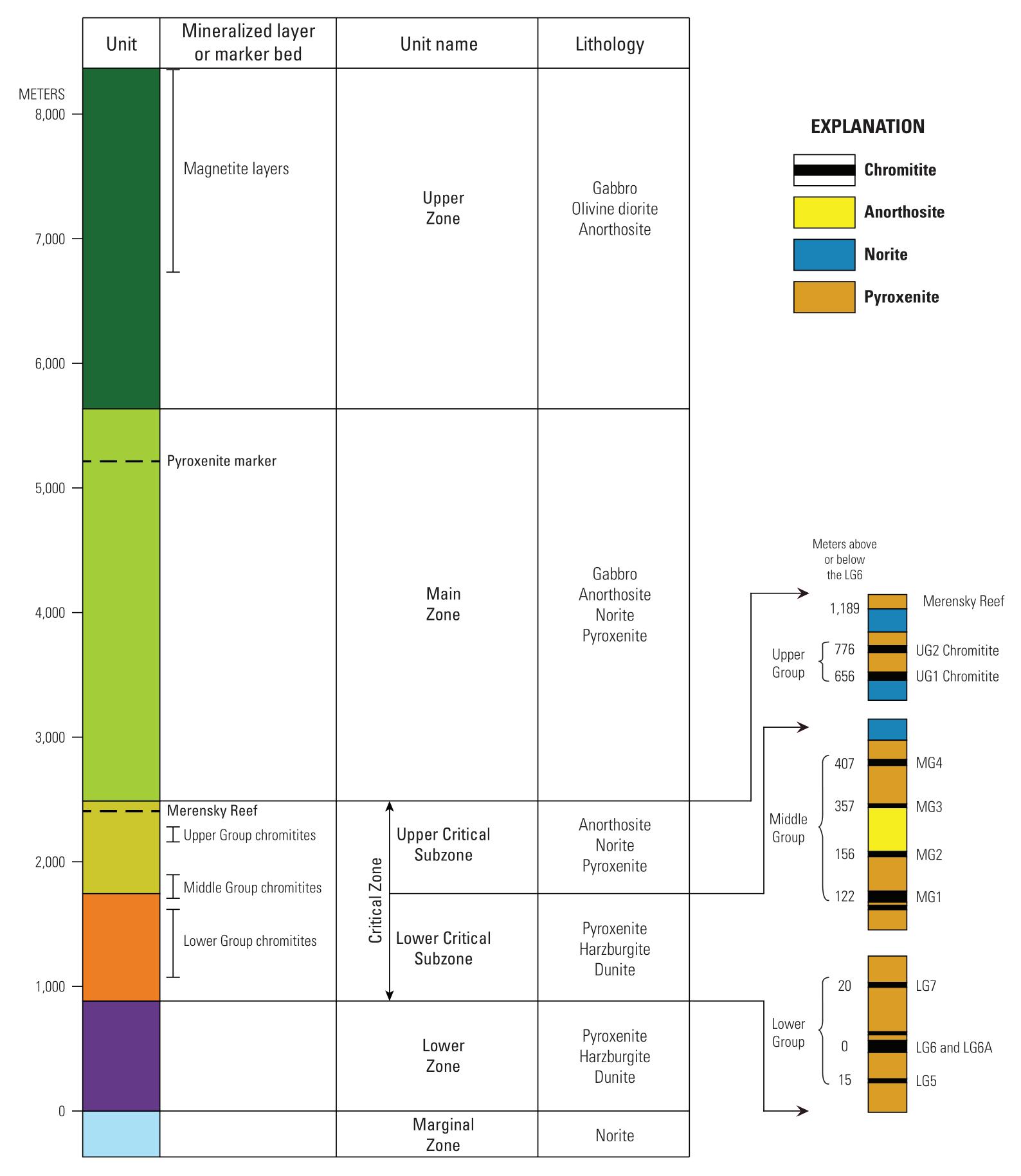
The RLS is subdivided into five zones (Marginal, Lower, Critical, Main and Upper Zones; Figure B2) with the chromium and PGE enriched layers in the Critical Zone. Vanadium mineralisation occurs in the magnetite layers of the Upper Zone. Chromitite layers of the Lower and Middle Groups have been mined extensively.
Figure B1. Map of the Bushveld Igneous Complex (Taylor et al 2005)
PGE-Bearing Chromitite Layers
All the chromitite layers contain PGEs, most notably reaching values of 4 to 7 ppm (grams/tonne) in the UG2 and Merensky Reef intervals near the top of the Critical Zone. The UG2 contains chromitite and subordinate pyroxenite, while the Merensky Reef is a norite with chromitite and sulphide layers. Both are typically around 30 to 100 cm in thickness. The UG2 Reef was the main target at Kennedy’s Vale. A UG2 Pegmatoid (0 to 3 m thick) is overlain by the main UG2 Chromitite (60 to 120 cm) and capped by the UG2 Pyroxenite. Mineralization is dominated by Platinum and Palladium, with 8% rhodium. The Merensky Reef hosts thick pyroxenite separating the chromitite stringers, which come together in pothole structures. This succession is overlain by pegmatite and melanorite. There is also a Platreef in the northern limb with norites and pyroxenites overlain by peridotite and then by further pyroxenites and norites, with common xenoliths of country rock.
Potholes are subsidence structures occurring within most chromitite seams (Figure 11). They are generally circular features, of varying diameter, where the reef(s) and overlying stratigraphic layers appear to have sunk into the underlying units. The reefs thin or pinch out on the edges of such structures. PGE grades are often disrupted. The degree of potholing can be as much as 25 %. UG2 potholes are usually shallow, saucer shaped with an undulating character, while Merensky Reef potholes are steep sided and irregular in profile. Dolerite dykes may also be encountered, usually steeply dipping and 5 to 10 m wide.
Other Resources
The Lower Group of the Critical Zone also contains chromitite-bearing intervals. The LG6 or Lower Group 6 Chromitite layer (also termed the Steelpoort Seam in the eastern Bushveld) is the most economically important chromitite horizon. The LG6 is about 90 cm thick. This interval has been mined extensively, including at Wintersveld Chrome Mine (Figure B3). The Upper Zone contains around 21 magnetite layers, ranging from massive to disseminated, associated with gabbro and diorite. The vanadium content is higher (over
2.2% V2O5 in places) in the lowermost layers and has been mined at Vansa Vanadium and elsewhere (Figure 4).
The RLS is considered to have formed by fractionation of a tholeiitic magma, sourced from at least seven centres of eruption. The first silicate minerals which crystallised and settled out are rich in magnesium and iron (mafic), while the later, lower temperature deposits of crystallization are calcium, aluminum and sodium silicates (silicic). Many cycles are preserved, with chromitite associated with
the mafic intervals and magnetite with the silicic deposits. The mechanism by which the chromitite seams were formed are hotly debated. They may have formed when a chemically primitive magma intruded into an existing magma chamber. Gravity settling may also have occurred. The process of PGE mineralization is also in question and may relate to hydrothermal fluids, crystallization and subsequent collection by oxides or sulphides.
Figure B2. Stratigraphy of the Bushveld Igneous Complex (Zientek et al 2010, USGS)
UPPER ferrogabbronorite, magnetite gabbro anorthosite and ferrodiorite, with layers of massive and disseminated vanadiumbearing titaniferous magnetite
MAIN noritic to gabbronoritic
CRITICAL (CZ) PGE-bearing chromitite layers hosted by orthopyroxenite and subordinate harzburgite (Lower CZ) and interlayered orthopyroxenite, norite and anorthosite (Upper CZ)
LOWER layered dunite, harzburgite and orthopyroxenite
MARGINAL norite and pyroxenite
1,000-2,700
Note the location of Kennedy’s Vale.
Vanadium (45% of world’s known reserves); Titanium; Phosphate
1,600–3,500
930-1500
900–1,600
250 (not always present)
PGEs (88%); Chrome (72%)
Figure B3. Map of the Eastern Limb (Viljoen 2016).
Table 1. Stratigraphic summary of the Rustenberg Layered Suite (RLS).
Figure B4. LG6 Chromitite seam in open cast mine (https://swapx.co.za/)
REFERENCES
Anglo American Platinum. 2023. Ore Reserves and Mineral Resources report.
Dwarsrivier Mine. 2026. https://dwarsriviermine.co.za/ Accessed January 2026.
Eastplats. 2017. Annual Information Form.
Evans, V. and Graham, C. 2020. Shaft sinking from 1970 to 2007: Mechanical excavation. CIM Magazine. https://magazine.cim.org/en/ the-evolution-of-shaft-sinking/evolution-of-shaft-sinking-part-six-en/
Von Gruenewaldt, G. 1977. Bushveld complex. Encyclopedia of Earth Sciences Series. Springer Nature.
Von Gruenewaldt, G., Sharpe, M.R. and Hatton, C.J. 1985. The Bushveld Complex: Introduction and Review. Bull. Soc. Econ. Geologists. Vol. 80, no. 4, pp. 803-812.
Hall, M. and Montpellier, B. 2010. Technical Report for the Kennedy’s Vale Project. Prepared for Eastern Plats Ltd.
Kintek Solutions. 2025. How do rotary kilns work? A Guide to Industrial Heating & Material Processing. https://kindle-tech.com/faqs/how-dorotary-kilns-work? Website updated December 2025.
Latypov, R., Costin, G., Chistyakova, S. et al. 2018. Platinum-bearing chromite layers are caused by pressure reduction during magma ascent. Nat Commun 9, 462 (2018).
Mungall, J.E., Kamo, S.L. and McQuade, S. 2016. U–Pb geochronology documents out-of-sequence emplacement of ultramafic layers in the Bushveld Igneous Complex of South Africa. Nature Communications, 7:13385.
Porter Geoconsultancy. 2019. Bushveld Complex - Overview of Teconics, Geology and Mineralisation.
R. P. Schouwstra and E. D. Kinloch. 2000. A Short Geological Review of the Bushveld Complex. Plutinum Metals Review, 2000, 44, (1). 33-39.
Scoon, R.N., Costin, G. and Grabe, P.J. 2017. Geology and Origin of the Vanadiferous Fe-Ti Oxide-rich Kennedy’s Vale Discordant Body, Eastern Limb of the Bushveld Complex, South Africa. South African Journal of Geology. Vol. 120.2, pp. 250-271.
Smith, D.S., Basson, I.J. and Reid, D.L. 2003. Normal reef subfacies of the Merensky Reef at Northam Platinum Mine, Zwartklip Facies, Western Bushveld Complex, South Africa. The Canadian Mineralogist. Vol. 42, pp. 243-260 (useful pothole descriptions).
Steelpoortdrift Vanadium Project. 2026. https://www.mining-technology. com/projects/steelpoortdrift-vanadium-project-south-africa/ website accessed January 2026.
Taylor, C.D., Schulz, K.J., Doebrich, J.L., Orris, G.J., Denning, P.D., and Kirschbaum, M.J. - Geology and nonfuel mineral deposits of Africa and the Middle East, USGS Open-File Report 2005-1294-E, Public Domain, https://commons.wikimedia.org/w/index.php?curid=56451561
https://urbancrows.com/2019/07/16/the-deep-level-mine-geologistand-the-business-of-shaft-sinking/ (website written by a former geologist, Ralph Rushton, working in South Africa)
https://www.valterraplatinum.com/site-services/contact (website relating to the revamped Vansa Vanadium mine)
Van der Merwe, J. and Cawthron, R.G. 2005. Structures at the base of the Upper Group 2 chromitite layer, Bushveld Complex, South Africa, on Karee Mine (Lonmin Platinum). Lithos 83 (2005) 214–228
Viljoen, M. 2016. The Bushveld Complex. Host to the World’s Largest Platinum, Chromium and Vanadium Resources. Episodes Vol. 39, no. 2. Wikipedia (accessed January 2026). https://en.wikipedia.org/wiki/ Bushveld_Igneous_Complex
Witley, J. and Minnitt, R.C.A. 2017. Using short deflections in evaluating a narrow tabular UG2 Reef platinum group element mineral resource. The Journal of the Southern African Institute of Mining and Metallurgy. Vol. 117. 179-187.
Zientek, M.L., Causey, J.D., Parks, H.L. and Miller, R.J. 2010. Global Mineral Resource Assessment: Platinum-Group Elements in Southern Africa—Mineral Inventory and an Assessment of Undiscovered Mineral Resources, USGS Scientific Investigations Report 2010–5090–Q
The Bedrock Bash is CEGA’s night to celebrate the volunteers who keep our organization rock solid. From field trips to technical talks, they ’re the foundation behind everything we do
Join us for a high-energy spring social filled with great people, strong connections, and well-earned shout-outs. Whether you’re a longtime member, a new geoscientist , or just curious about the geocommunity, come connect and see what CEGA is all about
A P R I L 1 6 – 1 8 , 2 0 2 6
There is still limited time to secure your spot at this popular tournament, which welcomes curlers of all levels for friendly competition and valuable networking.
Sponsorship opportunities are also a Inquire today. r y E L 8 2 o this omes orking. e available.
Alberta Palaeontological Society 29th Annual Symposium
Saturday - Sunday | 9 AM to 5:00 PM | MountRoyal University
SATURDAY, MARCH 14, 2025
9:00 – 9:15 am Opening Statements Cory Gross, APS President Symposium Introduction Mona Trick, APS Symposium Chair
9:15 – 10:15 am Tracing Faunal and Environmental Changes Through Time: The Palaeontological Power of Fish Microvertebrate Fossils
Dr. Julien Divay, Palaeoichthyologist, Hon. Research Associate, Royal Tyrrell Museum of Palaeontology
10:15 – 10:30 am COFFEE BREAK
10:30 – 11:30 am Fishes in a Suit of Armour - The Story of Placoderms, One of Our Oldest Jawed Relatives
Dr. Melina Jobbins, Palaeobiologist, University of Manitoba
11:30 – 12:00 pm The Impact of Heavy Industry on Significant Discoveries of Fossil Marine Reptiles in Alberta
Darren H. Tanke, Senior Technician II, Royal Tyrrell Museum of Palaeontology, Drumheller, Alberta
12:00 – 1:00 pm LUNCH BREAK
1:00 – 1:30 pm The Driftwood Canyon Fossil Beds, Smithers, Northern British Columbia - An Amazing Well-Preserved and Highly Diverse Eocene-age Terrestrial Paleoecology
Tako Koning, P. Geol, Senior Geologist - Consultant
1:30 – 2:00 pm Left Behind: Previously Unrecognized Trace Fossils with Stories to Tell Dr. Jon Noad, Stantec Consulting; University of Adelaide
2:00 – 3:00 pm POSTERS & DISPLAYS BREAKOUT SESSION AND COFFEE BREAK Poster presenters are requested to be with their posters
3:00 – 3:30 pm Alberta’s Paleocene Insects: New Insights from a Fossil Legacy
Kano Sasaguchi, Department of Biological Sciences, University of Alberta
3:30 – 4:30 pm Three-Horned Faceoff: A Tale of Canadian Triceratops and Why They Matter
Dr. Emily Bamforth, Curator, Philip J. Currie Dinosaur Museum
4:30 – 4:45 pm Hope Johnson Award Presentation Mona Trick, APS Symposium Chair
4:45 pm
Closing remarks for Paleo 2026 Mona Trick, APS Symposium Chair
OIL RESERVOIR ENGINEERING FOR GEOSCIENTISTS Short Course
Monday, March 16, 2026
8:30 AM – 4:30 PM
Instructor: Kamal Malick, Anschutz Exploration
Location: Calgary Petroleum Club
Online registration closes: March 9, 2026
nline 9
GAS RESERVOIR ENGINEERING FOR GEOSCIENTISTS Short Course
Tuesday, March 17, 2026
8:30 AM – 4:30 PM
Instructor: Kamal Malick, Anschutz Exploration
Location: CEGA Downtown Calgary Classroom
Online registration closes: March 10, 2026
li i t ti l M h 10
ECONOMIC ANALYSIS AND DECISION MODELLING Short Course
Wednesday, March 18, 2026
8:30 AM – 4:30 PM
Instructor: Kamal Malick, Anschutz Exploration
Location: Calgary Petroleum Club
Online registration closes: March 11, 2026
nline 11
PRACTICAL APPLICATION OF ICHNOLOGY TO CLASTIC FACIES ANALYSIS: CORE WORKSHOP Short Course
Wednesday, April 22, 2026 – Friday, April 24, 2026
8:15 AM – 4:30 PM
Instructor: Scott Botterill, Alberta Geological Survey
Location: AER Core Research Centre
Online registration closes: April 17, 2026
nline closes 17
GEOLOGY FOR NON-GEOLOGISTS
Short Course
Thursday, April 23, 2026
8:30 AM – 4:30 PM
Instructor: Michael Webb Michael Webb Geoconsulting
U
O M
CARBONATE CORE WORKSHOP Short Course
OIL RESERVOIR ENGINEERING FOR GEOSCIENTISTS Short Course
Wednesday, April 29, 2026 – Friday, May 1, 2026
Monday, March 16, 2026
8:30 AM – 4:30 PM
8:15 AM – 4:30 PM
Instructors: Eva Drivet, Drivet Geological Consulting Ltd.; David Hills, Entropy Inc.
Instructor: Kamal Malick, Anschutz Exploration
Location: AER Core Research Centre
Location: Calgary Petroleum Club
24
Online registration closes: April 24, 2026
Online registration closes: March 9, 2026
PETROPHYSICS ESSENTIALS: FUNDAMENTALS TO APPLICATION Short Course
GAS RESERVOIR ENGINEERING FOR GEOSCIENTISTS Short Course
Thursday, April 30, 2026 – Friday, May 1, 2026
Tuesday, March 17, 2026
8:30 AM – 4:30 PM
8:30 AM – 4:30 PM
Instructor: Kamal Malick, Anschutz Exploration
Instructors: Reigh MacPherson, MacPherson Energy Consulting; Jeff Dickson, Strathcona Resources Ltd.; Felix Todea, Strathcona Resources Ltd.
Location: CEGA Downtown Calgary Classroom
Location: Calgary Petroleum Club
Online registration closes: March 10, 2026
24
Online registration closes: April 24, 2026
ECONOMIC ANALYSIS AND DECISION MODELLING Short Course
MODERN FLUVIAL SYSTEMS Field Trip
Wednesday, March 18, 2026
8:30 AM – 4:30 PM
Thursday, May 14, 2026
8:00 AM – 5:00 PM
Instructor: Kamal Malick, Anschutz Exploration
Location: Calgary Petroleum Club
Leaders: Matt Caddel, BP Canada; Greg Baniak, PETRONAS Canada; Cynthia Hagstrom, Nova Geoscience
Location: Downtown Calgary Departure
Online registration closes: March 11, 2026
Online registration closes: May 8, 2026
8
PRACTICAL APPLICATION OF ICHNOLOGY TO CLASTIC FACIES ANALYSIS: CORE WORKSHOP Short Course
UNDERSTANDING NATURALLY FRACTURED ROCKS Short Course
Wednesday, April 22, 2026 – Friday, April 24, 2026
Thursday, May 14, 2026
8:15 AM – 4:30 PM
8:30 AM – 4:30 PM
Instructor: Scott Botterill, Alberta Geological Survey
Instructors: Marian J. Warren, Jenner Geoconsulting; Mark Cooper, Sherwood Geoconsulting
Location: Calgary Petroleum Club
Location: AER Core Research Centre
Online registration closes: May 8, 2026
8
Online registration closes: April 17, 2026
INTRODUCTION TO WCSB AND PETROLEUM SYSTEMS Bootcamp Course Series
GEOLOGY FOR NON-GEOLOGISTS Short Course
Wednesday, May 20, 2026
Thursday, April 23, 2026
8:30 AM – 4:30 PM
8:30 AM – 12:30 PM
Instructor: Michael Webb Michael Webb Geoconsulting
Instructor: Jim Barclay
METHODOLOGY FOR DESCRIBING CLASTIC FACIES AND CORE LOGGING Bootcamp Course Series
Thursday, May 21, 2026
8:15 AM – 4:30 PM
Instructor: Michael Webb, Michael Webb Geoconsulting Ltd.
Location: AER Core Research Centre
Online registration closes: April 24, 2026
nline r gistration pril 24
SEQUENCE STRATIGRAPHY OF MARGINAL MARINE AND INCISED VALLEY DEPOSITS; CORE-BASED EXAMPLES FROM THE WCSB Bootcamp Course Series
Friday, May 22, 2026
8:15 AM – 4:30 PM
Instructor: Michael Webb, Michael Webb Geoconsulting Ltd.
Location: AER Core Research Centre
Online registration closes: May 15, 2026
nline r gistration 15
TRIASSIC OF NORTHEASTERN BRITISH COLUMBIA: CONSTRUCTING A DEPOSITIONAL AND STRATIGRAPHIC FRAMEWORK Field trip
Date: May 26-29, 2026
Leader: John-Paul Zonneveld, University of Alberta
Location: Fort St. John, British Columbia
Online registration closes: May 19, 2026
nline r gistration 19
INTRODUCTION TO WELL LOGGING Bootcamp Course Series
Wednesday May 27, 2026
8:30 AM – 12:30 PM
Instructor: Kelly Skuce, CORE Petrophysical Consulting
Location: Calgary Petroleum Club
Online registration closes: May 20, 2026
nline r gistration 20
CANYON CREEK MISSISSIPPIAN FIELD TRIP Bootcamp Course Series
Thursday May 28, 2026
7:00 AM – 5:00 PM
Leader: Murray Gilhooly; Byron Veilleux, Conjugate Geologic Services; John Weissenberger
2025 HONORARY MEMBERSHIP AWARD
Thomas Moslow
Dr. Thomas (Tom) Moslow is an internationally renowned clastic sedimentologist and subsurface geologist who has divided his 45-year career between academia and industry. Tom has worked for several Canadian oil and gas energy companies, taught, and supervised graduate students as a professor at two Alberta universities and conducted numerous core studies, field trips, and professional development courses as a consultant. He personally discovered several oil and gas pools in the Cretaceous and Triassic of western Canada and became a leader in the exploration and development of the Montney Formation. His influence was evident in many industry successes, through his mentorship and teaching of students and industry geologists. Tom has distinguished himself by prominently leading the application of modern depositional environmental interpretations through corebased observations to determine reservoir trends and predict new subsurface hydrocarbon pools.
Tom received his Bachelor of Science degree in Marine Science from Long Island University in 1975, followed by a Master of Science in Marine Geology from Duke University (1977), and a Ph.D. in Geology from the University of South Carolina in 1980. His thesis and dissertation research, conducted under the advisership of Duncan Heron at Duke and Miles O. Hayes at South Carolina, was focused on the stratigraphy and Holocene evolution of the barrier island coastlines of North and South Carolina. During that time, sediments were a passion for Tom, while rocks were an afterthought. Much was to change during his career and eventually Tom became an expert on the interpretation and analysis of ancient shoreline successions in both the subsurface and outcrop.
He started his career as a research geologist at Cities Services Technology Center in Tulsa, Oklahoma, focusing on exploration and production research, a path that would serve him well as his career progressed between tenured professorship and a successful leader and co-founder of several oil and gas companies in Calgary. Highlights of Tom’s career would include Associate to Full Professor at the University of Alberta (1987-1995), Geological Advisor at Canadian Hunter (1996-1997), Chief Geologist at Ulster Petroleum (1997-2000), co-founder and Vice President, Exploration at Midnight Oil in 2000 and Vice President of Geology at Daylight Energy in 2005. In 2012, he formed his own independent consulting
business (Moslow Geoscience Consulting Ltd.) and is active today in projects involving core description and subsurface investigations of Lower Triassic and Cretaceous reservoirs. Over the period 1997-2026, Tom has also been an Adjunct Professor at the University of Calgary Department of Earth, Energy and Environment.
Dr. Moslow has been a long-standing member with CSPG/CEGA and has generously shared his knowledge and learnings through conference presentations, core workshops, field trips, and short courses over the past 35+ years. Most notable were his contributions as co-editor and contributor to the two-volume special edition of the Bulletin of Canadian Petroleum Geology on the Montney Formation in 2018, and co-instructor of the CEGA Montney continuing-education course that he has run with his former student Prof. John-Paul Zonneveld.
Tom has been a huge contributor to the CSPG/CEGA having jointly published over 100 peer reviewed papers and co-presented numerous talks and posters at Canadian and international conferences. More significantly, Tom has taught numerous short courses and field trips in both modern and ancient environments (75+), showing his passion for viewing and understanding “the rocks”.
Dr. Moslow has received numerous awards from our Society/ Association including the Tracks Award (1999), Stanley Slipper Award (2021), Medal of Merit (2025), numerous service and best paper/presentation convention awards and was also a CSPG Distinguished Lecturer in 2019. An example of Tom’s ability to bring out the best in people is that six of his graduate students have won the society’s best MSc. Thesis or Ph.D. Dissertation awards.
Tom is a true unicorn having a career that spanned both academia through industry leadership roles, and although he has had a hugely successful career in both sectors, he has taught, mentored, and influenced many leading geoscientists, while expressing the importance of interpreting the rocks because “rocks don’t lie”. His publications, awards, and the achievements of his students further highlight his broad influence. Tom has made a huge impact to Canadian geoscience and has made outstanding technical and educational contributions to the CSPG/CEGA, his geoscience community. We are very proud to welcome Dr. Tom Moslow as a CEGA honorary member recipient.
MEDAL OF MERIT
FOR BEST PAPER RELATED TO CANADIAN PETROLEUM GEOLOGY
The Medal of Merit has been awarded since 1952 and is the most prestigious and oldest technical award of the society. The medal is awarded annually for the best peer reviewed paper on a geological subject related to the petroleum geology or the geology of energy generation and extraction, of Canada. The stated objectives of the Medal of Merit Award are: to promote the preparation and publication of geological papers of high quality, to give honorable recognition to works of merit, and by means of suitable publicity, to bring the attention of the members and of the public to the activities of the geological petroleum profession by awarding the Medal of Merit annually for the best paper.
Daniela Becerra MEDAL OF MERIT
Daniela Becerra is a Geologist at SLB Canada and was recently assigned as the Talent Acquisition Manager for SLB’s Canadian operations. Before transitioning into this new role, she worked on integrated end to end geoscience consulting projects and provided global support for E&P software and training on applied machine learning topics for SLB customers. Daniela holds a PhD in Geology from the University of Calgary (2022), a Master of Science in Geology from the University of Oklahoma (2017), and a Bachelor of Science from the Universidad Industrial de Santander in Colombia (2013). Her research interests focus on reservoir characterization and geological modeling for both conventional and unconventional reservoirs.
Amin Ghanizadeh MEDAL OF MERIT
Dr. Amin Ghanizadeh is a geoscientist and subsurface engineer with 15+ years of international experience across Iran, Australia, Germany, and Canada. From 2014–2024 he worked at the University of Calgary, supporting industry–academic research on unconventional reservoirs, subsurface fluid–rock interactions, and low-carbon subsurface technologies, while also teaching and mentoring graduate researchers. His research output includes 70+ peer-reviewed papers (as of January 2026) and numerous conference contributions, reflecting sustained contributions to tight reservoir characterization, multiphase transport, and applied geoscience methods. Since 2025, Amin has been with delta h Ingenieurgesellschaft mbH (Germany), working at the water–energy nexus where hydrogeological system modelling supports challenges spanning groundwater systems and geothermal applications.
Christopher R. Clarkson MEDAL OF MERIT
Christopher R. Clarkson is the Tamaratt Research Professor in Transitional Energy, and the Ovintiv/Shell Chair in Unconventional Gas and Light Oil research, in the Department of Earth, Energy, and Environment (formerly Geoscience), and an adjunct professor with the Department of Chemical and Petroleum Engineering at the University of Calgary. His work focus in the industry was on exploration for, and development of, unconventional gas (UG) and light oil (ULO) reservoirs. His research focus, since coming to the University of Calgary in 2009, has been on advanced reservoir characterization and evaluation methods for UG-ULO, such as rate- and pressure-transient analysis, flowback analysis, DFIT analysis, and reservoir sample analysis. He is also interested in the application of these advanced reservoir characterization methods to the evaluation of transitional energy pathways using the subsurface, such as geological CO2 storage, hydrogen storage, geothermal energy, and critical elements recovery. Clarkson is the PI of the industry- and governmentsponsored research group called “Tight Oil Consortium” and co-PI of the recently-initiated “Transitional Energy Consortium”.
MEDAL OF MERIT
Humberto Carvajal-Ortiz
Humberto is currently GEOLOG’s Americas Geochemistry Manager, providing support and expertise (technical and analytical) for projects involving unconventional resources around the USA, Canada, Australia, the Middle East, and Argentina, and conventional petroleum systems around the world. He is also mentoring younger staff and non-geochemists on how to apply geochemistry to charge-risk assessments, completions, and production. Humberto previously worked as a Chief Geochemist & Geochemistry SME at Core Laboratories in Houston. Additionally, he has worked as geochemist and geologist since 2004 for institutions and companies such as Ecopetrol, and the Smithsonian Tropical Research Institute (STRI) in Panama, providing technical support for projects in the Colombian and Venezuelan Andes. He holds a B.Sc. in Geology from Universidad Industrial de Santander (2004) in Colombia, a M.Sc. in Geology & Geochemistry from Iowa State University (2007), and a Ph.D. in Geology and Geochemistry from Indiana University Bloomington (2012). He has multiple peer-reviewed publications in the fields of biogeochemistry, organic & petroleum geochemistry, and petroleum geology. He is also Guest editor and peer-reviewer for Marine and Petroleum geology, AAPG Bulletin, FUEL, Geochimica et Cosmochimica Acta, Organic Geochemistry, Palaeogeography, Palaeoclimatology, Palaeoecology, International Journal of Coal Geology, and Boletin de Geologia (UIS).
MEDAL OF MERIT
Dr. Thomas F. Moslow, Ph.D., P.Geol.
Tom is President of Moslow Geoscience Consulting Ltd. and an Adjunct Professor in the Department of Earth, Energy and Environment at the University of Calgary. He has co-edited three volumes for the Bulletin of Canadian Petroleum Geology and is the co-author of over 100 refereed journal publications. CEGA (CSPG) awards include the Tracks Award (1999), Stanley Slipper gold medal (2021) and Honorary Membership (2025). His consulting work is focused on the Lower Triassic of Western Canada and unconventional reservoir geology in general.
Lavern D. Stasiuk MEDAL OF MERIT
Lavern D. Stasiuk is principal at Stasiuk Petrography Ltd. (2018), Calgary. During his 35+ year career as an organic petrologist in the geosciences, Lavern has been employed as a senior research scientist and chief of organic petrology laboratories with Natural Resources Canada (NRCan), Geological Survey of Canada, Calgary, and as global domain expert and subject matter expert (SME) with Shell. Lavern received his B.Sc. (1984), M.Sc. (1988) and Ph.D. (1991) from the University of Regina. This was followed by a Natural Sciences and Engineering Research Council (NSERC) laboratory visiting postdoctoral fellowship (19921994) at the Graduate Science Centre (GSC), Calgary. His Ph.D. thesis, “Organic Petrology and Petroleum formation in Paleozoic source rocks, northern Williston basin, Canada” was awarded the CSPG/CEGA Graduate Thesis Award in 1992. Other awards include The Society of Organic Petrology (TSOP) Outstanding Student paper (1991), NATO Oil Shale ASI Best Poster (1993), and Vincent E. Neslo, AAPG Eastern Section Best Poster (2000). Lavern’s involvement in societies include President of the Canadian Society for Coal and Organic Petrology, Vice-President of TSOP, CSPG/CEGA Program Director, and Co-convenor of the International Committee for Coal and Organic Petrology (ICCP) nomenclature working groups. He has also acted as associate editor for International Journal of Coal Geology, Marine and Petroleum Geology, Bulletin of Canadian Petroleum Geology, and is currently an associate editor of The Bulletin of Canadian Energy Geoscience Association. Lavern has published and worked extensively on all aspects of organic petrology, spanning Proterozoic to Modern sediments from numerous basins around the globe, with significant emphasis on Westen Canada Sedimentary and Williston basins.
From the Desk of the AER
Sharing Knowledge and Data from the Alberta Geological Survey
Alex MacNeil, Principal Geoscientist
The two premier events for geoscientists working the Western Canada Sedimentary Basin are CEGA’s annual Core Conference and Geoconvention, scheduled this year for early May. The events offer unique opportunities for technical development, the exchange of ideas, and discovering new opportunities on many fronts. The following article highlights a number of presentations being delivered by staff from the Alberta Geological Survey at these events, and is prepared mostly from content provided by the authors.
Starting with presentations anchored by geological core studies, two contributions are planned for Core Conference. A recent focus in our basin are studies on Alberta’s basement as it has a fundamental impact on the geology of the province and influences resources as varied as geothermal, helium, lithium, base metals, and petroleum. Eric Morley and Arif Rabbani will present Alberta’s Precambrian Basement: Novel Data and Preliminary Interpretations. They note that Alberta’s basement is geologically diverse with at least 17 distinct tectonic domains. Despite its importance, there is a stark scarcity of geological data in Alberta on the basement, largely due its subsurface depth. Although limited by available core data, the Alberta Geological
Survey has undertaken a program to study many of these intercepts through geological, geochemical, geochronological, and geomechanical analyses. Core logging and petrographic descriptions combined with a full suite of whole rock lithogeochemistry revealed general lithologic trends, correlations to tectonic settings, and indications of potential minerals systems. Thermal conductivity measurements coupled with rock mechanics testing allowed for initial investigations of deep geothermal potential. Further work, including U-Pb geochronology and Sm-Nd isotope geochemistry, combined with continuing interpretations will further reveal the Precambrian basement’s geological history and potential resources.
FIGURE 1 Cross-section through the Basal Cambrian Sand in east-central Alberta.
Perhaps almost in perfect stratigraphic order, the presentation by Eric and Arif is followed by The Cambrian Cold Lake Conundrum: New Models for Old Rocks by Dave Herbers and Tyler Hauck, which is focused on the Basal Cambrian Sand. If you were not able to attend the CEGA workshop presented in March, this is the next best option. This presentation leverages recent industry investment in core and wireline data to resolve the geological ambiguity of the Cold Lake Basal Cambrian Sandstone, a critical CCS target that is anomalously thick compared to regional trends (Figure 1). They propose a new Incised Valley Fill model that challenges traditional interpretations, suggesting that the majority of this high-quality sand package is actually younger (Earlie Formation) in age. This stratigraphic redefinition significantly refines our predictive models for reservoir volume and extent in the area.
Several presentations are planned for Geoconvention and this year the survey is highlighting results from its mineral mapping program, work to unlock geothermal potential in Alberta, research into induced seismicity, and advanced techniques making use of remote sensing/ Earth observation technologies. Levi J. Knapp, will lead a session dedicated to Critical Minerals in western Canada, covering a wide range of sources including hard-rock, softrock, and brine, in addition to industrial byproducts such as coal ash and oil sands tailings.
In his presentation titled Alberta’s Mineral Mapping Program: New Data, Tools, and Insights on Mineral Prospectivity, Levi will provide an update on the program and highlight the rebuilt Alberta Interactive Minerals Map and several associated products. Mike Belosevic will present Critical mineral systems in the Canadian Shield of northeastern Alberta: Results from the 2025 AGS field campaign which is aimed at communicating results from recent evaluations of the critical mineral potential of Alberta’s exposed Canadian Shield as part of the province’s minerals strategy and action plan. Field programs conducted since 2023 have identified new mineral occurrences and mineral systems within basement gneisses, supracrustal rocks, and Taltson magmatic zone plutons of the exposed Canadian Shield in northeastern Alberta. The 2025 campaign (Figure 2) integrated geological mapping, geophysical interpretation, structural measurements, and geochemical sampling to develop mineral system models across the Lake Athabasca, Colin Lake, and Leland Lakes regions. Results reveal elevated REE, U, Th and Li concentrations in sheared, high grade metamorphic pegmatites and deformed granitoids along major structural zones. Future AGS work will apply U-Pb geochronology and trace element analysis to constrain the timing and processes governing these critical mineral systems.
Complimentary to Mike’s presentation is Multispectral and field-spectroscopy-based mapping of metamorphic and alteration minerals in the Andrew Lake Region, northeastern Alberta by Subir Chowdhury and Scott Kelly. Subir and Scott are two of our Earth Observation specialists who use remote sensing methods for an array of geological and regulatory purposes and we decided that this year it would be ideal for them to share some of their expertise with the Geoconvention community. This study applies multispectral satellite imagery and field spectroscopy to map metamorphic and alteration minerals in the Andrew Lake region of northeastern Alberta. As described in Mike’s presentation, the area contains complex high-grade gneisses, schists, granitoids, and supracrustal rocks with potential for critical minerals. WorldView-3 VNIR-SWIR data, combined with 523 TerraSpec Halo field spectra,
FIGURE 2 Geologists from the Alberta Geological Survey collecting outcrop data from the Canadian Shield in northeastern Alberta, summer of 2025.
were used to detect diagnostic iron and hydroxyl absorption features at outcrops and in samples. Spectral matching techniques successfully delineated amphibolite, hornblende granodiorite, and muscovite rich schists, while felsic units were less distinct. A mineral absorption feature map highlighted zones with more than four spectral absorptions, which strongly correlate with geochemical anomalies in elements such as Ce, Nd, Pr, Li, U, and Th. Seasonal imagery differences influenced outcrop detection, emphasizing the need for multi-season acquisitions and continued field validation to refine exploration targeting in this Shield environment.
Moving from the shield in northeastern Alberta to oil and gas sites, Subir Chowdhury and Scott Kelly will also present Mapping undesired Vegetation on Oil and Gas Reclamation Sites using a multi-sensor Approach. As petroleum geoscientists we are most often focussed on subsurface issues but from a broader industry perspective it is important to understand the full life-cycle of resource development including closure and site reclamation. This presentation will provide a crash-course on one approach used by the AER to assess site reclamation in Alberta. Field data from oil and gas sites across northern and west-central Alberta were used to validate satellite-based assessments. Sentinel-2 imagery, analyzed with the Spectral Angle Mapper algorithm during peak flowering, effectively identified Canada thistle and associated non-native grasses. Long-term Landsat timeseries (1984-2024) characterized disturbance and recovery patterns using the LandTrendr algorithm, while SuperDove imagery improved detection of small vegetation patches through cumulative NDVI and phenological metrics. Integrating land-cover classification and monthly leaf-area index further enhanced mapping accuracy. Validation using Sentinel-2 imagery produced an overall accuracy of 78%, with Canada thistle showing the strongest spectral separability. The results highlight the value of a transparent, repeatable Earth Observation workflow to support reclamation monitoring and inform future regulatory policy, especially for remote or difficult-to-access sites.
Induced seismicity in the province continues to increase and is an important area of research by the Alberta Geological Survey. The presentation Induced or Natural? Assessing the North Peace River Seismic Cluster Using Nodal Array Data, Regional Catalog, and Questionnaire Inputs by Hanh Bui, Mauricio Reyes Canales, Tyler Hauck, Javad Yusifbayov, and Chet Goerzen investigates the origin of the seismicity using a three-month deployment of high-resolution seismic nodal arrays integrated with regional earthquake catalogs and industrial operations data. The nodal deployment detected 340 seismic events, including 29 with magnitudes ≥ 1, 13 of which were not recorded by the regional network. The primary depth distribution is between 4 and 6 km below the surface, suggesting that the events occurred within the Precambrian basement. The nodal array also identified a small seismic cluster within 15 km of disposal wells that was previously undetected by the regional network, demonstrating the enhanced detection capability and improved local resolution provided by the nodal array, which is critical for assessing potential induced seismicity. With an integrated approach the team was able to identify a strong temporal association that persists across multi-year lags. Seismic questionnaire results indicate that 61% of points support an induced
origin, 28% are equivocal, 11% indicate insufficient information, and 0% support a natural origin. Overall, these findings demonstrate that nodal arrays significantly improve detection and interpretation of local seismicity, providing valuable input for identifying and characterizing induced seismicity.
Another induced seismicity presentation titled Induced-SeismicityDriven Geological Modeling of the Steep Creek Reef Incorporating the Gold Creek Seismic Cluster will be delivered by Jinze Xu, Tyler Hauck, Mauricio Reyes Canales, Claudio Virues, Baohong Yang, Chet Goerzen, Alexandra Robertson, Shaurat Sayani, and Nick Roman. In this study recent instances of disposal-related induced seismicity have led to the production of a 3D geological model of the Leduc Formation Steep Creek reef in west-central Alberta. Unlike traditional modeling approaches, the design of this model was guided by seismic activity, specifically incorporating the Gold Creek seismic cluster, to better capture the subsurface dynamics associated with induced events. The geological framework incorporates formation tops, while property modeling establishes porosity-permeability relationships from core data. Seismic events within the Gold Creek seismic cluster were used to define a polygon that divides the model into induced seismicity and noninduced seismicity sectors, enabling focused analysis within the Gold Creek seismic cluster. Pressure modeling based on reservoir pressure measurements shows pressure buildup in the induced seismicity sector tracking injection rate increases during the study period. The simulation-ready model applies local grid refinement in the induced seismicity sector while using coarser cells in the non-induced seismicity sector. This induced-seismicity-driven workflow integrates geology and geophysics, providing a simulation-ready framework for analyzing temporal relationships between injection activities, pressure evolution, and induced seismicity related to water disposal activities.
On the geothermal front, Arif Rabbani and Chad Glemser will present Geothermal Potential of Alberta: Intermediate-Depth Temperature Mapping and Precambrian Basement Characterization . This presentation introduces research into province-wide intermediate-depth (150-1000 m) temperature mapping and geothermal characterization of the Precambrian basement. For better characterization of temperature profiles at intermediate depths, the work leverages quality controlled well-based temperature data. Initial results show a broadly linear increase in temperature with depth at intermediate levels across southern Alberta, supporting low-enthalpy applications such as groundsource heat pumps, thermal energy storage, and district heating. The basement research integrates newly acquired aeromagnetic data and laboratory measurements of basement samples, including petrography, radiogenic heat production, thermal conductivity, and rock mechanical properties. These data reveal systematic variability in heat production, Curie point depth, and mechanical behaviour across tectonic domains, with implications for deeper geothermal systems, including enhanced geothermal systems and closed-loop technologies, as well as drilling performance. Together, these datasets provide new insights into Alberta’s geothermal resource base and directly support emerging efforts focused on intentional basement drilling and technology deployment, including the Alberta Drilling Accelerator.
Did you know that coal, bitumen and the oil sands all contain critical minerals? To better understand how these disseminated minerals may become concentrated and exploitable in waste streams, Calla Knudson and Levi Knapp from the survey with co-authors Jason Ng, Heather Kaminsky, Maksuda Khatun, Van Luu, and Song Gao from the Northern Alberta Institute of Technology will present Investigating Industrial Mine Waste and Byproduct Streams as Potential Alternative Sources of Critical Minerals in Alberta. In this study seven coal sites (five active or legacy surface coal mines and two former coal-fired power stations) were selected for sampling. Samples of coal, fly ash, bottom ash, coarse rejects, plant waste, and tailings were collected across multiple locations and depths (0–20 m) using auger and grab sampling techniques. A comprehensive suite of analyses was used to characterize representative samples in terms of their physical, mineralogical, and geochemical properties, and included particle size distribution (PSD) analysis, loss on ignition (LOI), methylene blue index (MBI), bulk and clay-fraction X-ray diffraction (XRD), wavelength-dispersive X-ray fluorescence (WDXRF), inductively-coupled plasma optical emission spectroscopy (ICP-OES) and mass spectroscopy (ICP-MS), CHNS, optical
microscopy, and scanning electron microscopy (SEM) techniques. The coal ash samples exhibited an average total REE concentration (303 ppm) slightly above the economic cutoff grade of 300 ppm for coal and coal by-product proposed by the U.S. Department of Energy and are relatively enriched in light rare earth elements (LREE), particularly La, Ce, and Nd. Multiple ash and coarse-reject samples show high proportions of critical REE and favorable outlook coefficients (critical REE/excessive REE), suggesting they could be promising sources of REE. Consistent with previous studies, critical mineral concentrations tend to be higher in the finer ash samples relative to the coarser tailings samples. Although the concentrations of some critical minerals (e.g., Mn, Ti, Ga, and V) are significantly enriched relative to values measured in typical coals, they remain below their respective economic cutoff grades. While these results highlight coal ash and select coarsereject materials as potential targets for further REE exploration, the variability observed between sites indicates the need for more localized characterization to inform resource assessments and development decisions. Similar characterization is ongoing for oil sands mine waste and byproduct steams.
We hope you can join us at the Core Conference and Geoconvention and look forward to sharing our projects and results with the community.
REGISTRATION NOW OPEN
GeoConvention returns in 2026 at the Calgary TELUS Convention Centre, bringing together the largest integrated Earth science program in Canada Hosted in partnership by the Canadian Energy Geoscience Association and the Canadian Society of Exploration Geophysicists, GeoConvention delivers a dynamic technical program, expansive exhibition hall, and unmatched networking opportunities From cutting-edge research to practical case studies, the conference connects geoscientists across disciplines to share knowledge, explore emerging technologies, and strengthen Canada’s earth science community
2026 UPCOMING EVENTS INFORMATION
MARCH
March 14 & 15 In-Person
Saturday - Sunday PALEO 2026
The annual symposium of the Alberta Palaeontological Society (APS) is a two-day event with lectures, posters, and showcase displays presented by mix of avocational and professional palaeontologists from all over Canada. There will be fossil displays and activities of interest to a wide audience, including families. Saturday events are free to the public!
Location: Mount Royal University, Room B108 4825 Mt Royal Gate SW, Calgary, AB
March 18
Wednesday, 12:00 PM -1:00 PM In-Person
Heavy Oil/Oil Sands Technical Division
Chemical Fluid Tracer Diagnostic Applications for Flow Assurance and Production Profiling in Open Hole Multilateral Wells
Speaker: Cole Mombourquette, ProTechnics
Location: New CEGA Classroom, 500 4 Ave SW, Calgary, AB
March 19
Thursday, 11:30 AM - 1:00 PM In-Person
Technical Luncheon
Deciphering the Influence of Inherited Basin
Topography on Early Cretaceous Sediment Routing in the Western CA Foreland Basin: Insights from Stratigraphic Data & Zircon Geochronology