Important Mason-Dixon Manuscript Map & Related Documents
Important Mason-Dixon Manuscript Map & Related Documents October 29, 2026
Auction begins at 10:00 am EST brunkauctions.com 117 Tunnel Road | Asheville, NC 28805 828-254-6846 info@brunkauctions.com NCAL 3095, VAAL 2908001063 Terms of sale available online.
As auctioneers, we have the great good fortune of handling beautiful, rare, valuable, and unusual objects. In this case we will add to that list, singular. Each map in this select group was purposefully chosen for its significance in determining the longest running land dispute in American history—the disputed boundary line between Pennsylvania and Maryland—the boundary line that ultimately came to represent the cultural divide between the North and the South. The first, a widely distributed map Novi Belgii Novaeque Angliae nec non partis Virginiae Tabula multis in locis emendata, would significantly influence the outcome of the ongoing border dispute between Maryland and Pennsylvania. In 1685 the matter was taken up by the Privy Council in London. Visscher’s map was used in the proceedings but it incorrectly placed Cape Henlopen farther south than it was and because of this, many acres were ultimately gained by William Penn. With this realization the debate continued. The second, and most anticipated of the group, A Plan of the West Line or Parallel of Latitude which is the Boundary between the Provinces of Maryland and Pensylvania [sic], did, in fact, establish a boundary between the province of Pennsylvania and the province of Maryland and ended the dispute. In 1750 it was decreed that a complete survey of the boundary be undertaken. Charles Mason and Jeremiah Dixon were hired to complete the survey in a month, but in practice, it required almost five years of work. The resulting document, this survey map, is a pivotal part of our American history. Mason and Dixon were young, capable and accomplished. They were highly regarded in their native England, having completed the successful observation and recording of the 1761 transit of Venus from the Cape of Good Hope. Their competent handling of the astronomical expedition impressed their
scientific community, especially the Royal Society and the proprietary families of Pennsylvania and Maryland. They were also remarkably thorough. What we now call the Mason-Dixon Line is a survey that has withstood the test of time and the challenge of modern instruments. It also came to delineate the northern states that did not tolerate human enslavement and the southern states that did when it was adopted for use as a boundary demarcation in the 1820 Missouri Compromise. The third map and accompanying pamphlet, Articles of Agreement Made and Concluded Upon Between the Right Honourable the Lord Proprietary of Maryland and the Honourable the Proprietarys [sic] of Pensilvania, [sic] &c… are what we might think of as the denouement of the land dispute between Pennsylvania and Maryland. In England, three manuscript documents, penned on vellum outlining the terms of the agreement between Maryland and Pennsylvania, and containing an inset map by John Senex, were distributed to each of the proprietors. One of Thomas Penn’s copies of the agreement was given to Benjamin Franklin from which he printed 500 copies in pamphlet form, each accompanied by a woodcut version of Senex’s inset map. The American document and map are rarely found together as they are here. The fourth and final map, A Chorographical Map, of the Country, round Philadelphia, shows us how the Mason-Dixon Line and the boundaries that resulted from the survey were adopted and utilized by later cartographers. This rare map illustrates Washington’s 1777 campaign and it also includes the eastern border of Maryland and Pennsylvania as well as a circle around Newcastle, Delaware used to delineate a portion of the east-west line. We hope you enjoy the journey.
1 Visscher, Schenk - Novi Belgii Novaeque Angliae nec non partis Virginiae Tabula... Novi Belgii Novaeque Angliae nec non partis Virginiae Tabula multis in locis emendata, Peter Schenk after Nicolaes Visscher, Amsterdam, 1729 or later, vibrantly hand colored engraving on laid paper, plate 18-3/8 x 21-7/8 in., sheet 22-1/8 x 26 in.; in modern parcel gilt frame, 30-1/2 x 33-1/8 x 7/8 in. Provenance: Martayan Lan Augustyn, Inc., 2002; Private Collection Estimate: $3,000 - $4,000 The inclusion of “Petr. Schenk Iun:” in the cartouche indicates this map is fifth state. For more information, see Margaret Beck Pritchard and Henry G. Taliaferro, Degrees of Latitude (2002), pp. 86-89, no. 11. Nicholas Visscher’s widely distributed map was the first to contain the famous inset view of New Amsterdam, the third known engraved view of New York. An important geographical feature of this map is that a significant error contained within the map influenced the outcome of the dispute between Cecil Calvert, Second Baron Baltimore, and William Penn. Lord Baltimore's 1632 charter for Maryland granted him land that included territory that would eventually become Delaware, provided that it had not been settled by people other than Native Americans. Immediately after Penn received his grant from Charles II in 1681, he disputed Lord Baltimore’s belief that his charter included the east side of the Delmarva Peninsula because it had been previously settled by the Dutch and Swedes. Following decades of unsuccessful attempts to negotiate a resolution between the two proprietors, Charles Calvert, Third Baron Baltimore, and Penn’s heirs John, Thomas, and Richard Penn, met in London in 1732 and drafted and signed the Articles of Agreement which specified the precise geographical locations upon which to establish the border. Both parties submitted maps to be consulted during the negotiations. Lord Baltimore insisted upon using Visscher’s map in the negotiations, regarding it as a trusted source since it had been given to him by one of his agents in Maryland. Unfortunately for Lord Baltimore, Visscher incorrectly placed the location of Cape Henlopen farther south than it actually was, resulting in the loss of thousands of acres of land for Lord Baltimore. It is possible that Penn was aware of the error in Visscher’s map. Penn’s copy of Visscher’s map survives in the John Work Garrett Library at Johns Hopkins University. On the reverse, in William Penn’s hand, is the endorsement “The Map by which the privy Council 1685 settled the Bounds between the Lord Baltimore & I, & Maryland & Pennsylvania & Territories or annexed Countys. WP.”
6
Important Mason-Dixon Manuscript Map & Related Documents | October 29, 2026
For full cataloging, condition notes, and images, see brunkauctions.com
7
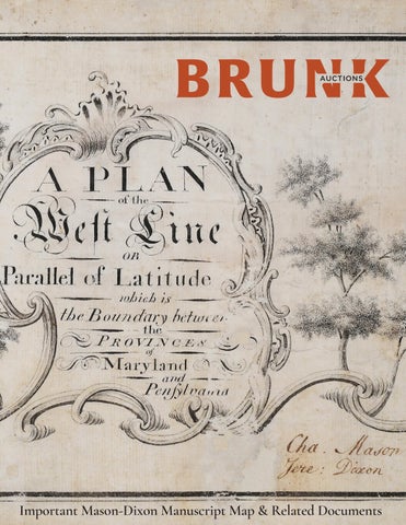
2 Mason & Dixon - A Plan of the West Line...of Maryland and Pensylvania [sic] A Plan of the West Line or Parallel of Latitude which is the Boundary between the Provinces of Maryland and Pensylvania [sic], manuscript map surveyed, drawn, and signed by Charles Mason and Jeremiah Dixon, drawn in Philadelphia between December 26, 1767 and February 29, 1768, six sections on laid paper joined together, ink over graphite pencil with a double ruled ink border, signed “Cha. Mason/Jere: Dixon” at lower right in iron gall ink, sheet 6-1/2 x 76 in.; modern parcel gilt frame, 18 x 87-3/8 x 1-3/4 in. Provenance: Benjamin Chew (1722-1810); Christie’s, New York, NY, “Colonial American Documents including the Declaration of Independence from the Chew Family Papers”, April 1, 1982, lot 23; Malcom S. Forbes for the Forbes Foundation; Christie’s, New York, NY, “Forbes Collection of American Historical Documents”, March 27, 2002, lot 4; Private Collection
The original Mason-Dixon survey map, illustrating the boundary line between Maryland and Pennsylvania, resolved the longest running boundary dispute in American history, and is notably the most famous survey ever undertaken. In undertaking the first geodetic survey ever conducted, Mason and Dixon performed one of the greatest scientific achievements of its time. Measuring only 6-1/2 inches in height, this map represents one of the most symbolic icons of American history. More than half a century after Mason and Dixon surveyed the boundary, the line was extended westward as part of the Missouri Compromise, the law that effectively determined the division between free and slave states. Thus, more than just illustrating the resolution of a boundary dispute, the Mason-Dixon Line became an enduring symbol of the cultural and political divide between the North and the South. Furthering the symbolic significance of the Mason-Dixon Line, historians have suggested that the term “Dixie” referring to Southern culture, evolved from a linguistic shortening of Jeremiah Dixon’s name.
Estimate: $800,000 - $1,200,000
8
Important Mason-Dixon Manuscript Map & Related Documents | October 29, 2026
The origins of the dispute between William Penn and Cecil Calvert, Second Baron Baltimore A variety of factors contributed to boundary line controversies in the American colonies— geographical errors, a general lack of understanding of the geography, and monarchs reissuing land previously granted by their predecessors. Each of these factors were at play when Charles II granted William Penn a charter for Pennsylvania in 1681. Lord Baltimore's 1632 charter for Maryland granted him land the length of the Potomac River and northward as far as the 40th parallel. His original charter also included territory that would eventually become Delaware, provided that it had not been settled by people other than Native Americans. Penn’s grant extended from the 42nd parallel southward to the border of Maryland at the 40th parallel. The southern boundary was to be determined “by a circle drawn at twelve miles distance from New Castle, northward and westward unto the beginning of the fortieth degree of northern latitude, and then by a straight line westward. . .” Two primary issues were at stake. The first to be resolved was whether the settlements along the east side of the Delmarva Peninsula belonged to Lord
Baltimore. Procuring access to the Delaware River was of paramount importance to Penn and the success of his colony, therefore he disputed Lord Baltimore’s belief that his grant included the east side of the Delmarva Peninsula because it had been previously settled by the Dutch and Swedes. The more difficult issue to resolve was whether Lord Baltimore’s northern boundary should be at the 40th degree of north latitude as accurately surveyed or at the latitude where it was thought to have been at the time that Lord Baltimore received his grant. When Charles II issued Penn’s grant, they both believed that the 40th parallel intersected the circle around New Castle but it was actually located some 20 miles farther north. A compromise was eventually reached in 1732 when a Court of Chancery ruled to establish the line slightly further south than the 40th parallel resulting in a significant loss of land for Lord Baltimore (see lots 1 and 3, Visscher and Franklin). Lawsuits continued to be filed, temporary agreements were negotiated, and attempts were made by the Privy Council to settle the discrepancies between the charters, however the dispute was not settled until 1760 when negotiations were resumed and the controversy was adjudicated in England, largely in Penn’s favor. Three years later Mason and Dixon were hired to sail to America to survey the line.
Charles Mason and Jeremiah Dixon Determining the precise boundary between the two colonies required expertise beyond that of the colonial commissioners and their survey team. The commissioners, in consultation with the director of the Royal Observatory in Greenwich, chose Charles Mason and Jeremiah Dixon, who had recently returned from an expedition sponsored by the Royal Institute to observe the transit of Venus, as the most qualified to conduct the survey. They arrived in North America in November of 1763 bringing with them the same scientific instruments used to observe the transit of Venus, the most important of which was a zenith sector, a specialized telescope that points directly overhead allowing the astronomer to locate the exact position of the stars necessary to determine an accurate reading of latitude. Mason and Dixon began their survey by measuring the 83-mile north-south division between Maryland and Delaware known as the "Tangent Line". The 233-mile west line, represented on this manuscript map, was officially ordered by the Boundary Commissioners on June 18, 1765. Mason kept a daily journal, which included mathematical and astronomical data, survey notes, correspondence, and detailed their daily progress. Dixon, who was an
experienced surveyor, is likely the one who prepared the map and cartouche. The 364-page journal reveals the extraordinary difficulties the survey team endured, necessitating the use of Native American guides and teams of men to clear sightlines. On October 9, 1767, Mason wrote, “This day the Chief of the Indians which joined us on the 16th of July informed us that the above mentioned War Path was the extent of his commission from the Chiefs of the Six Nations that he should go with us, with the Line; and that he would not proceed one step farther Westward.” The running of the west line took fully two and a half years. On September 11, 1768, Mason recorded the last entry in the journal, “At 11h 30m A. M. went on Board the Halifax Packet Boat for Falmouth. Thus ends my restless progress in America.” Mason and Dixon’s survey map At the culmination of the survey, Mason and Dixon were instructed “to draw and make out from your Minute Books an Exact and true Plan and Survey of the Boundary Lines... you are to sign and deliver the same either to the Commissioners of Pennsylvania or Maryland...” Two maps were prepared — one illustrating the line as surveyed for the Delmarva Peninsula, and this map, recording the boundary of the west line. The two manuscript maps were
delivered to Pennsylvania Commissioner Richard Peters on January 29, 1768, from which 200 copies were engraved and printed in Philadelphia. This map and numerous other documents pertaining to the Pennsylvania-Maryland boundary dispute were deposited with Pennsylvania Commissioner Benjamin Chew, and remained in the family until they were sold at Christie’s in 1982.
have given away a set of the map to John McAllister in 1863 (Streeter 32), gave a set to another friend, not realizing that the eastern sheet he selected was part of the original manuscript.” (Wainwright, “Tale of a Runaway Cape: The Penn-Baltimore Agreement of 1732” in The Pennsylvania Magazine of History and Biography, V. 87 (July 1963), pp. 288.)
The manuscript map illustrating the eastern boundary of “Three Lower Counties” was donated to the Princeton University Library in 1864. This “West Boundary” manuscript was thought to be lost until 1963 when historians Nicholas Wainwright and Benjamin Chew discovered it among surviving Chew family papers. While comparing this manuscript map of the west line to the engraved versions, he wrote that “Mr. Chew noticed that the cartouche on the strip map differed from that on the other copy. It was soon realized that the strip map, despite its superficial appearance of being an engraving, was actually a manuscript. On Jan 15, this map was compared at Princeton with the other manuscript part signed by the surveyors. There was no doubt in any of the viewers’ minds that both were drawn by the same hand, presumably that of Charles Dixon [sic]. The Princeton part of the manuscript map was acquired by the family of its donor in 1864. No doubt, Benjamin Chew, III, who is known to
For full cataloging, condition notes, and images, see brunkauctions.com
9
3 Calvert, Franklin - Articles of Agreement..., with Framed Map of Maryland, Pensilvania [sic], and part of Virginia Articles of Agreement Made and Concluded Upon Between the Right Honourable the Lord Proprietary of Maryland and the Honourable the Proprietarys [sic] of Pensilvania, [sic] &c. Touching the Limits and Boundaries of the Two Provinces. With The Commission, Constituting certain Persons to execute the same, by Charles Calvert, Third Baron Baltimore, printed by Benjamin Franklin, Philadelphia, 1733, 18 pp., printed wraps, watermarked laid paper, 12-7/8 x 8-1/4 in., folding map has been removed and framed separately; uncolored woodcut map on laid paper, sheet 16-3/8 x 12-3/4 in.; modern parcel gilt frame, 26 x 22-3/8 x 1-1/2 in. Provenance: Sessler’s Bookshop, Philadelphia, Pennsylvania (accompanied by write up); Christie’s, New York, NY, “Printed Books and Manuscripts”, December 19, 2002, lot 213 (tag); Private Collection Estimate: $60,000 - $80,000 Following decades of unsuccessful attempts to resolve the exact location of the boundary between Maryland and Pennsylvania, Lord Baltimore petitioned the king to order the Penns to settle the border dispute. Attempting to avoid additional legal expenses, the proprietors of both colonies agreed to meet in London to reach a private settlement with London lawyer and colonial agent Ferdinando John Paris serving as mediator. In order to establish the boundaries, each of the proprietors submitted a map for reference. At Lord Baltimore’s insistence, his erroneous map (lot 1, Visscher) illustrating Cape Henlopen 25 miles below its true location, was used to as a guide determine the southern boundary of the three lower counties on the Delmarva Peninsula. The map was delivered to London cartographer John Senex to be engraved on copper. Three manuscript documents, penned on vellum outlining the terms of the agreement and containing the Senex map as an inset, were distributed to each of the proprietors. One of Thomas Penn’s copies of the agreement was given to Benjamin Franklin from which he printed 500 copies in pamphlet form, each accompanied by a woodcut version of the inset map by Senex. It has been suggested that Franklin himself, who had experience making woodcuts for printing, may have copied the London map. This is the first map printed in the English colonies south of New York. Despite the fact that Franklin printed 500 copies of the agreement, today they are exceedingly rare.
10
Important Mason-Dixon Manuscript Map & Related Documents | October 29, 2026
For full cataloging, condition notes, and images, see brunkauctions.com
11
4 Romans - A Chorographical Map, of the Country, Round Philadelphia... A Chorographical Map, of the Country, round Philadelphia, Carte Particuliere, des Environs de Philadelphie, Bernard Romans, Amsterdam: Covens et Mortier et Covens Junior, circa 1778, attractively hand colored engraving on watermarked laid paper, plate 12-3/8 x 13-5/8 in., sheet 17-1/8 x 21-7/8 in.; in modern parcel gilt frame, 24-1/4 x 25-1/2 x 1-1/8 in. Provenance: Martayan Lan Augustyn, Inc., 2002; Private Collection Estimate: $10,000 - $15,000 This rare map, engraved and published in Amsterdam, was based on an earlier map by surveyor Bernard Romans, Deputy Surveyor General for the Southern District of North America. Romans produced his map, virtually unobtainable today, to illustrate the Philadelphia campaign of 1777. He located the position of Washington’s camp near Valley Forge and the route of General Howe’s British forces at the outskirts of Philadelphia. While this map illustrates numerous additional features such as county and state boundaries, place names, major roads, and waterways, one of the most significant details relating to this sale is the precise location of the eastern portion of the boundary line between Maryland and Pennsylvania which had been surveyed by Charles Mason and Jeremiah Dixon. Romans delineated a circle around New Castle and a portion of the east-west line. Covens & Mortier (fl. 1721-1774) and later, Covens & Mortier & Covens, Junior (fl. 1774-1783) was a prolific Dutch firm that printed and published a variety of maps, atlases, and town plans. While it is not clear how their firm received a copy of Romans’ map, Michael Buehler of Boston Rare Maps has suggested that perhaps since Romans was born in Delft, he may have retained business connections in Holland.
12
Important Mason-Dixon Manuscript Map & Related Documents | October 29, 2026
For full cataloging, condition notes, and images, see brunkauctions.com
13
Exceptional Results for Maps and Manuscripts
The Printed Archetype of the United States Constitution, sold for $11,070,000
Exceptionally Rare Price-Strother Survey of North Carolina Map, sold for $418,200
Joseph F.W. Des Barres, Plan of the Posts of York & Gloucester, sold for $144,000
Articles of Confederation and Perpetual Union Between the Colonies, sold for $1,230,000
George Washington Signed Medical Discharge, 1783, sold for $31,980
Bishop James Madison 1818 Map of Virginia, sold for $264,000
Brunk Auctions is a leader in the sale of important maps and manuscripts, as well as other fine and decorative arts. Buyers appreciate our knowledgeable and attentive staff, sellers appreciate our record setting results. We always welcome quality consignments.
Notes