1. The Dawn of Cartography: From Peutinger to Kepler 14
Tabula Peutingeriana 16
Hereford Mappa Mundi 22
Universalis Cosmographia 24
Nova, et Integra Universi Orbis Descriptio 26
Altera Generalis Tab. Secundum Ptol. 28
Typus Orbis Universalis 30
Die ganze Welt in einem Kleberblat 32
Die erst General Tafel 34
Noua Orbis Terrarum Delineatio 36
2. The Dutch Golden Age: The Rise of the Modern Map 38
Typus Orbis Terrarum 40
Pars Orbis 42
La Herdike Enterprinse faict par le Signeur Draeck 44
O Caput elleboro Dignum... 46
Veritable Representation des Premieres Matieres ou Elements 48
Septentrionalium Terrarum Descriptio 50
Terrestrial Globe Gores 52
Orbis Terrae Novissima Descriptio 54
Nova Totius Terrarum Orbis Geographica ac Hydrographica Tabula 56
Werreldt Kaert 58
Nova Totius Terrarum Orbis Tabula 62
3. The French: Positivist Cartographic Imaginings 64
Mappe-monde Geo-Hydrographique 66
Le Globe Terrestre Représenté en Deux Plans-Hémisphères 68
Carte Très Curieuse De La Mer Du Sud 70
Le Globe Terrestre Representé en Deux Plans-Hemispheres 74
Mappe Monde nouvelle 76
Carte General Des Découvertes De L’Amiral de Fonte 78
Mappe-Monde ou Description du Globe Terrestre 80
Planisphere Physique 82
Mappemonde ou Description du Globe Terrestre 84
Mappemonde 86
4. Cartography of Colonialism 88
Designatio Orbis Christiani 90
Carte Generale de Toutes Les Costes du Monde 92
Carte Generale des Royaumes, Etats et Domaines 94
Essay d’une Carte Reduite 96
British Empire, Showing the Commercial Routes of the World 98
5. The Oriental Perspective: The East Asian Global Vision 100
Complete Map of the Nine Border Towns of the Great Ming 102
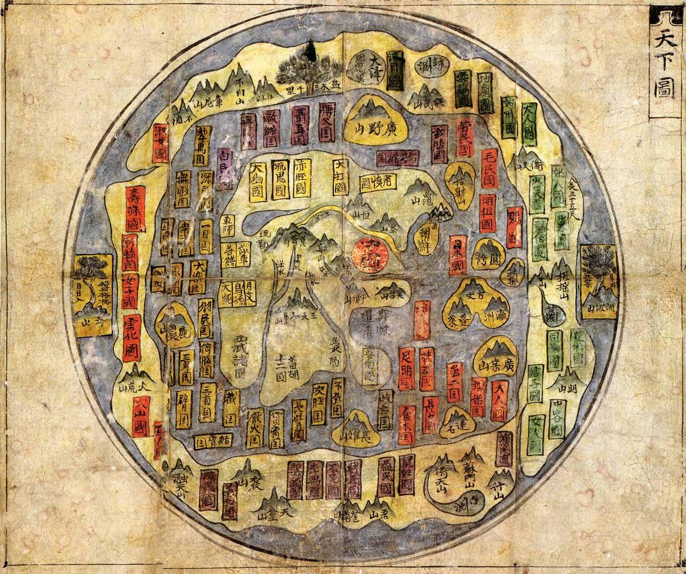
Map of all Under Heaven 104
Outline Map of All Countries of the Universe 106
All-Under-Heaven Complete Map of the Everlasting Unified Qing Empire 108
Map of the World 112
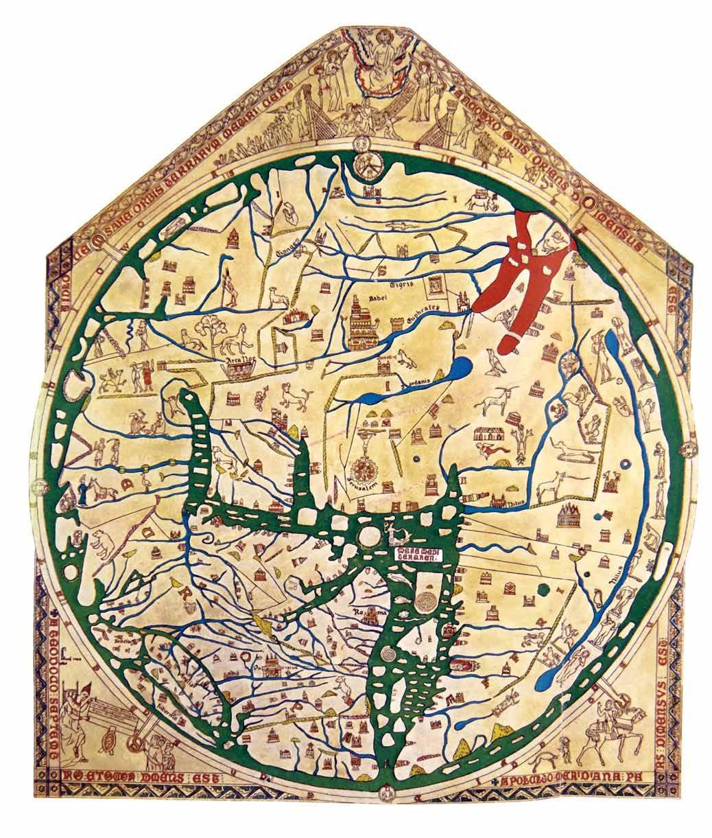
Hereford Mappa Mundi
This stunning manuscript from Hereford Cathedral, England, is the largest known example of a medieval world map. It was drawn on flayed calfskin around 1300 AD by Richard of Haldingham and Lafford, also known as Richard de Bello, a high-ranking cleric.
The Hereford Mappa Mundi is a near perfect example of a traditional medieval T and O (T-O) map, a Biblically inspired cartographic model popular during Europe’s Middle Ages. The map is hard to interpret by modern standards as it is drawn with the spiritual rather than Earthly world in mind, but with some imagination, it does become clear. Jerusalem, the religious center of the world, appears at its center. East is at the top of the map and the furthest eastward point is the Garden of Eden, or the Earthly Paradise. Eden is walled off and appears to be an island, thus suggesting inaccessibility from the mundane world. The large body of water at the bottom center of the map is the Mediterranean, with the Straits of Gibraltar marking the westernmost point. Africa occupies the right-hand part of the map with the river Nile somewhat easy to identify. Europe appears in the lower left quadrant.
Most of the more specific locations on the map are Biblical rather than geographical references and are, typically, associated with episodes from scripture. The site of Noah’s Ark, for example, is noted. Nevertheless, this being an English production, England, Ireland, and Scotland appear prominently in the lower left.
Today, as it has been for hundreds of years, the Hereford Mappa Mundi is housed at Hereford Cathedral in England. It is on display to the public.
bCartographer
Richard of Haldingham and Lafford (fl. c. 1275-1313) was an English clergyman and scholar. Also known as Richard de Bello, he was a high-ranking cleric, possibly a treasurer, and later prebend, at Lincoln Cathedral in Lafford. He was reassigned to Hereford Cathedral in 1305.
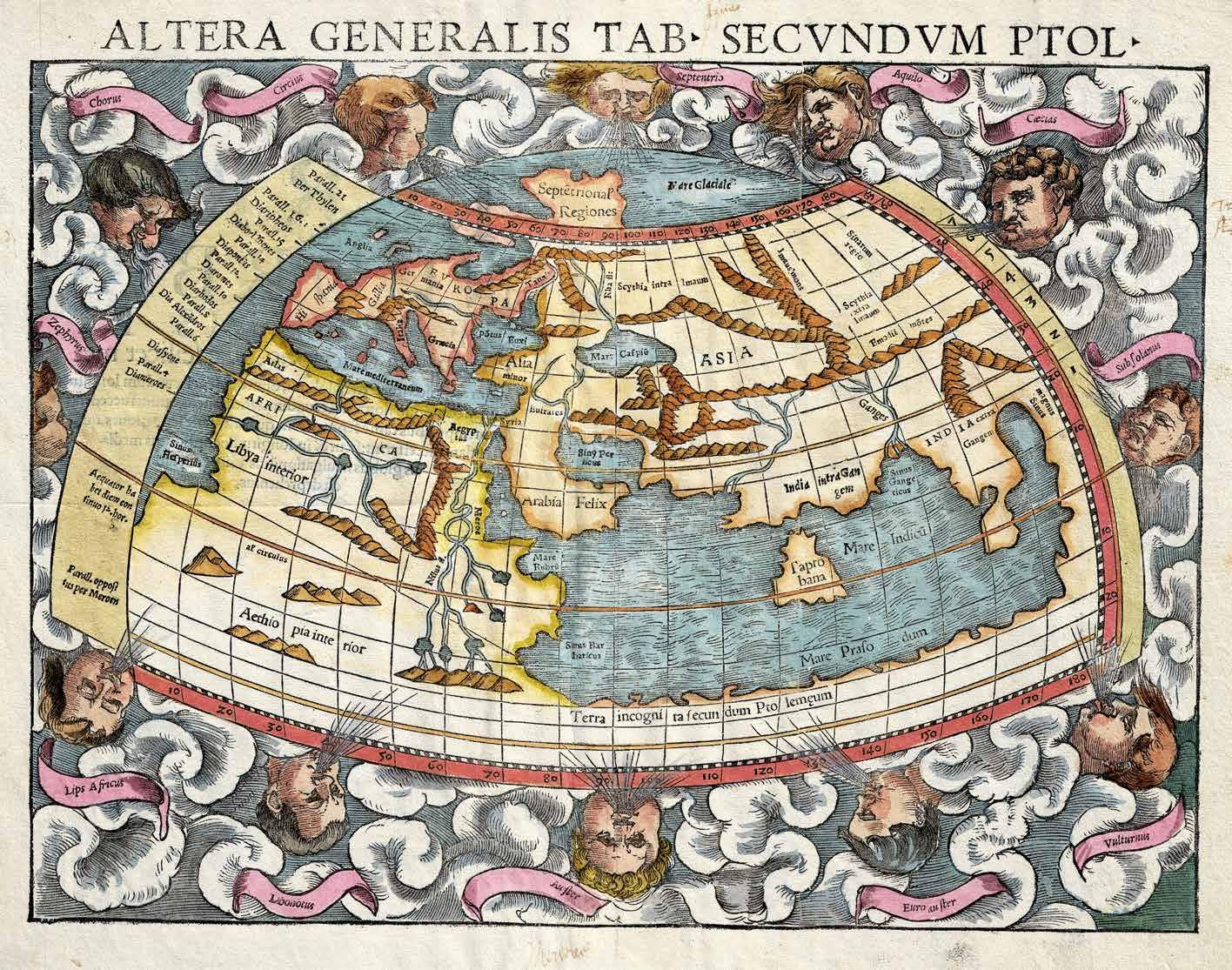
Altera Generalis Tab. Secundum Ptol.
Sebastian Münster produced this map in 1550 in order to illustrate the world as it was perceived using the Ptolemaic model most common prior to the Great Age of Discovery. Despite being published in the 16th century, this map offers a view of the world from the 2nd century. Münster’s work followed the cartographic vision presented in Claudius Ptolemy’s seminal work Geographia. Although many ‘Ptolemaic’ maps survive today, most are extrapolated from the text of the Geographia. It remains unclear if Ptolemy himself produced an actual map.
The “Old World” is somewhat limited from our modern perspective, covering only the areas from Indochina to the Atlantic Ocean and from the Equator to the Arctic. Europe, Arabia, and the Persian Gulf are recognizable. The Nile and the Niger are both visible in Africa. India is under-sized relative to “Tapobrana,” an archaic name for the important spice-trading center of Sri Lanka. Note how Africa continues at the base of the map to connect with Southeast Asia. The Indian Ocean is thus fully enclosed, a belief that was common until Bartolomeu Dias sailed around the southernmost tip of Africa in 1488.
Also of interest is the way Africa clearly extends southward below the Equator but is not even conjecturally mapped. It was believed in Ptolemaic times that these lands, referred to as the Tepid Zone, were full of monsters and too hot to sustain human life.
bCartographers
• Sebastian Münster (1488-1552) was a professor of Hebrew at the University of Basel, Switzerland. Münster had issued a call throughout Germany’s academic communities for cartographic information, in preparation for putting together the Cosmographia, and the book’s accuracy and scope were unprecedented. It sold well and went through 24 editions. The intricate woodcuts, by a variety of artists, were one of the reasons for its vast influence. It was produced for nearly 100 years. Most of Münster’s work was published by his sons. He died in Switzerland in 1552.
• Claudius Ptolemy (100-170 AD) was a Greek Alexandrian astronomer and mathematician considered to be the “Father of Cartography.” His most important geographical work, the Geographia, laid the foundation for modern geographical thought and included instructions on mapmaking and an extensive coordinate system. Ptolemy’s work was thought lost until it was reintroduced to European scholars during the Renaissance by the Moroccan scholar Muhammad al-Idrisi.
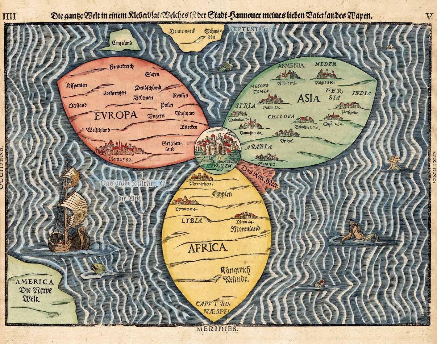
Die ganze Welt in einem Kleberblat
Heinrich Bünting’s thematic map of the world in the form of a cloverleaf was first issued in 1581. The map is drawn in the T-O style, a Biblically-based cartographic model that was popular prior to the rediscovery of Ptolemaic mapping in the 12th century. It is revelatory of just how slowly early discoveries and cartographic advancements made their way into regular usage that Bünting continued to embrace the T-O model more than 70 years after Waldseemüller’s advancements, and several hundred years after the rise of the Ptolemaic model. The religious interpretation of the three-part world is the essence of the T-O model. Typically, as here, Jerusalem, as the heart of the world, appeared at its center, with Europe, Asia, and Africa radiating outward. In Europe, Rome was given precedence and was the greatest city on the map outside of Jerusalem. In Asia, there are many cities, most of which like Babylon, Persepolis, and Damascus, were known to Europeans from Biblical tradition. India is identified as the farthest eastward point. Africa has only three cities, Meroe (Sudan), Cyrene (Libya), and Alexandria (Egypt). Curiously, England, Scandinavia (including Denmark), and the New World are divorced from the main body of the map, suggesting that Bünting was struggling to reconcile modern cartographic knowledge with his religiocentric values.
bCartographer
Heinrich Bünting (1545-1606) was born in Hanover, Germany. He studied at the University of Wittenberg. Graduating in 1569, after studying theology, he became a Protestant pastor. He retired to Hanover in 1600 after a dispute about his teaching. His book “Travel Through the Holy Scripture” (Itinerarium Sacrae Scripturae), which consisted of several maps printed in woodcut, became very popular and was reissued multiple times.
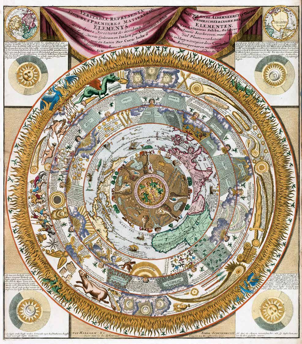
Veritable Representation des Premieres Matieres ou Elements
Eight concentric circles of the elemental spheres are illustrated with baroque grandeur. At the center is the fiery core of the universe, where angry souls burn and are tormented by demons in what can only be the Christian hell. Above this is the physicality of the Earth, a great earthen sphere with underground caves, waterways, mines (complete with miners) and deposits of precious metals. On the surface, the world of man is full of activity, including farming, traveling mining, and sailing as well as natural phenomena such as trees and volcanoes. Next, there is a map, which takes the form of a polar projection from the North Pole. This map is derived from De Jode’s 1593 Hemispheriu Ab Aequinoctiali Linea. The map covers roughly from the Mediterranean and Florida south to the Equator. Following this are three zones of air corresponding to Aristotle’s climatological treatises. Within these zones we can find observable weather patterns (such as rain, snow, and hail), and cosmic events, including the 1577 Great Comet. These are in turn embraced by the final sphere – the hermitic purifying realm of empyrean fire, where salamanders and phoenixes frolic.
Saliba’s world is both ordered and chaotic, spiritual and temporal, familiar and fantastical. His work attempts to reconcile Christianity with Greek philosophy, the Ptolemaic world view, Renaissance science, and mythology.
bCartographers
• Antonio Saliba was a Maltese cartographer, astronomer, theologian, and philosopher. Litte is known of his life.
• Cornelis de Jode (1568-1600) was a Dutch cartographer based out of Antwerp. De Jode was the son of Gerard de Jode, another cartographer of note. He studied at the Academy of Douai and, in 1591, took control of his father’s map published business. Cornelis completed and published his father’s great atlas, the Speculum Orbis Terrae. Unfortunately, faced with more innovative and sophisticated competition in the form of the Ortelius firm, and others, De Jode’s cartographic enterprises met with little success.
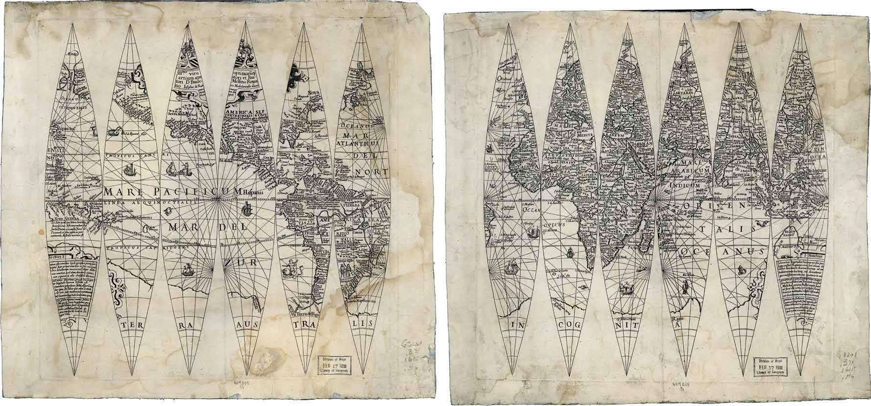
Terrestrial Globe Gores
b
Cartographer
Jodocus Hondius (1563-1612) was an important Dutch cartographer. Hondius inherited the 16th century plates of Gerard Mercator and republished them well into the 17th century, reviving the Mercator brand. His maps were far from slavish copies of Mercator’s map and included numerous important revisions. Even so, the significant influence of the Hondius firm cemented many outdated ideas into cartographic canon.
This remarkable set of globe gores was prepared by Jodocus Hondius in 1615. Gore sets like this were issued both for conversion to actual globes and, as here, separately issued as parts of books and atlases in the place of a more traditional projected world map. Gore sets could be easily cut out and wrapped around a wooden or glass sphere to form a proper globe. Typically gore sets also include northern and southern cap plates, but in the current example, due to its small size, about 19 cm in diameter, the gores extend from pole to pole. Although small, this map exhibits the exuberance and baroque ornamentation of Dutch Golden Age globes. The gores feature the most up to date cartographic information of the period that, at the time, was streaming into Dutch ports via trading empires such as the Dutch East India Company (VOC). The cartography offers much of note, including an embryonic mapping of Cuba, considerable accuracy in the East Indies due to VOC activity, and an insular rendering of Korea. The globe’s most arresting feature is its illustration of northern Australia. Australia was first encountered by Dutch VOC navigator Willem Janszoon in 1606, about 9 years before these gores were engraved. Janzoon had little inkling of the magnitude of his discovery and it was slow to appear on subsequent maps and globes. Nontheless, Australia here appears definitively, a broad but empty land south of Java. The nomenclature, including ‘Beach Regnu’ and ‘Maletur Regnu’ reference the journals of Marco Polo, who described such regions but provided little substantial content. Polo was commonly used by cartographers to give structure to the Asian and Southeast Asian part of their maps, but, as history has proved, much of his cartography was inaccurate and lacked sufficient detail to definitively associate with factual locations.
Courtesy of Library of Congress
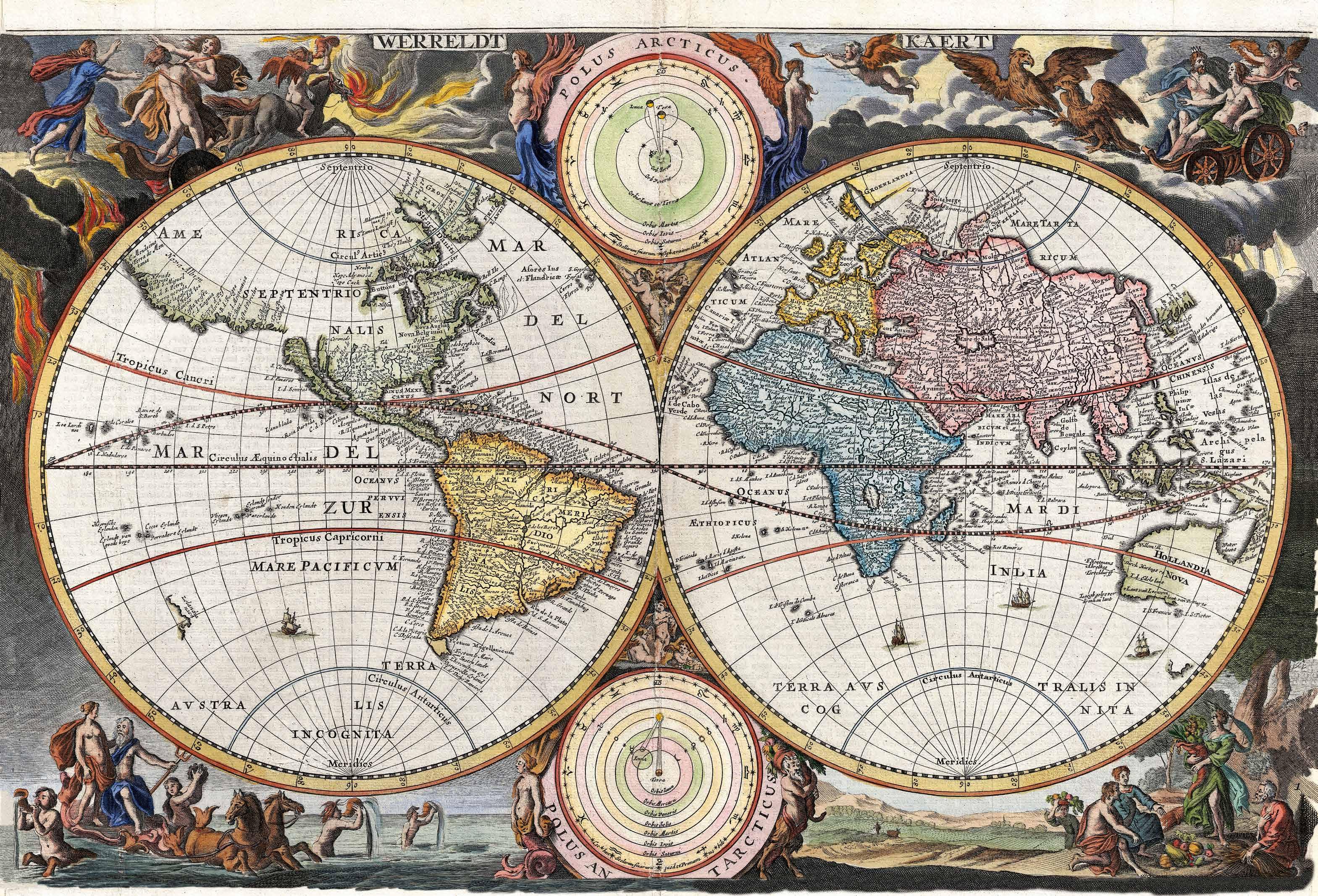
Werreldt Kaert
This gorgeous world map is a striking example of Dutch Baroque cartography. The borders are lavishly illustrated with allegorical imagery from classical mythology including Zeus with his chariot, Poseidon with his followers, Demeter receiving offerings, and Persephone being attacked. The map was created for the 1682 version of the Keur Bible by Nicolaas Visscher.
Visscher was a proponent of the insular California theory and, indeed, California is included here as an island. The idea of an island called “California” was initially proposed in a 1510 work of fiction by Rodriguez de Montalvo. In his romance novel, Las Sergas de Esplandian, he wrote, “Know, that on the right hand of the Indies there is an island called California very close to the side of the Terrestrial Paradise; and it is peopled by black women, without any man among them, for they live in the manor of Amazons.”
Following Francisco de Ulloa, Hernando Cortez traveled to Baja California shortly after its discovery and immediately claimed the ‘Island of California’ for the Spanish crown. It was not long after that it became clear that it was not an island. Nevertheless, recorded history and actual reality rarely march hand in hand. Francis Drake had sailed up the western coast of America and claimed ‘New Albion’ near Vancouver, and Washington State for the English crown. The influence of the Spanish crown, and the desire to maintain its claim on California, caused a resurgence in the insular California theory in the late 17th and early 18th centuries.
Elsewhere on the map, in an expansive Asia, Silk Route cities are noted including Kashgar, Tashkirgit, Samarkand, and Bukhara. South America and Africa have interiors that are almost entirely speculative, often filled with hopes and dreams. Many Europeans, for example, believed that King Solomon’s mines were hidden in South Africa. The Kingdom of Monomotapa, most often associated with the legendary mines, maintained an active trading network with India and Asia and did indeed have rich gold mines.
bCartographer
The Visscher family were prominent Dutch map publishers for nearly a century. The patriarch of the family was Claes Jansz Visscher (1586-1652) who, around 1620, established the firm in Amsterdam near the offices of Pieter van den Keer and Jadocus Hondius. Visscher meant “fisherman” and the family incorporated this icon into many of their maps, often signing maps “Pescador.” The firm was passed down successive generations of the Visscher clan until eventually sold to Peter Schenk.
Planisphere Physique
Rendered with the North Pole at its center, this 1781 map by Jean-Nicolas Buache de la Neuville is unusual both as a polar projection and for being a primarily real (rather than political) map. Although projected from the North Pole, the map embraces considerably more than the hemisphere extending south beyond Australia, Cape Horn, and New Zealand. The cartography is distinctly pre-Cook, with such ephemeral conventions as the Sea of the West and an unmapped eastern shore of Australia evident.
The focus of the map is physical geography, particularly the interplay of mountain ranges, river systems, and oceans. The striking color-coding corresponds to the oceans into which the rivers of each continent drain. Red represents the Pacific Basin, Yellow the Atlantic Basin, Green the Indian Ocean Basin, and Purple the Arctic Basin. This particularly is of note, as Buache’s geophysical theories advocated for a warm ice-free polar sea. In his Essai de Géographie Physique, Buache claimed, not without reason, that the Earth’s great river systems were influenced by both terrestrial and undersea mountain ranges that forced drainage into one oceanic basin or another. To confirm his theory, he added mountain ranges to this map where necessary, such as in South America as a channel for the Amazon River, and in Africa to channel the Nile, Congo, Niger, and other great rivers. He also incorporated the exploratory routes of Magellan, Quiros, and others, whose discoveries, he argued, confirmed the theories he advocated.
This map was originally published by Phillipe Buache in 1752. The present example was issued posthumously by his heir and nephew Jean-Nicolas Buache de la Neuville and the publisher Jean-Claude Dezauche.
Cartographer
Phillipe Buache (1700-1773) was a French cartographer and publisher. He began his career as an assistant to the famous cartographer Guillaume de L’Isle. Upon Guillaume de L’Isle’s death, he married de L’Isle’s daughter and took over the business. Buache was appointed Geographer to the King and often served as tutor to the young Dauphin, a position of privilege that he took advantage of to secure additional royal appointments later in his career. After his death in 1773, Buache’s business passed to his nephew, Jean-Nicolas Buache de la Neuville (1741-1825), who continued to publish updated versions of his maps.
Map of all Under Heaven
This unusual Korean world map was drawn in manuscript during the middle part of the 18th century. The map was a fine example the Cheonha-do (World Map) convention popular in Korea during the Joseon period (1392-1897). There were many versions of this map, some of which were printed in woodblock while others were copied in manuscript, as with this example.
From the earliest examples of the 16th century, to later examples dating to the late 19th century, there was little variation in the general design and layout. Although distinctly Korean, this map was based upon the teachings of the Warring States Period (475-221 BC) Chinese diviner, Zou Yan. Zou Yan’s teachings appeared to have been codified into map form in Korea during the 16th century.
The map presupposes a flat earth with an inner sea (Pihai, or “Little Sea”) and an outer sea (YangHai, “Greater Sea”). The large red dot at the center was Beijing and the central part of the map was occupied by China. The four great rivers of China were apparent: The Yellow River (Colored Yellow), the Yangtze River (running just south of Beijing), the Pearl River (central continent, bottom right) and the Lancang River (bottom left). Korea was a yellow region just to the east of Beijing and Japan appeared just offshore. The surrounding sea was bounded by a ring of land representing the rest of the world, although most of the place names were fictional. To the right and left of the outer ring continent were the sacred trees, Busang and Bangyeoksong, believed, according to the ancient shamanistic system of Korea, to be the sites of the sun’s rising and setting, respectively.
bCartographer
The cartographer is unknown.
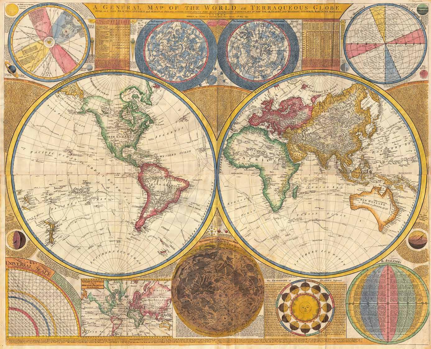
A General Map of the World, or Terraqueous Globe
This stunning and monumentally proportioned 1794 wall map of the world was issued by the Englishman Samuel Dunn. Dunn was a professor of mathematics, navigation, and astronomy and those interests were reflected in this informationally dense map. In addition to the map proper, which was presented on a double hemisphere projection, secondary maps illustrated the Solar System, the Moon, the northern and southern celestial hemispheres, and the world on an alternative Mercator Projection. Further charts and diagrams described the seasons, distance scales, astronomical calculations, and mathematical navigational systems.
Issued just before the turn of the century, Dunn’s work could be understood in the terms of nascent scientific idealism that would reach its peak in the coming Victorian Era. From the late 18th century, scientists ranged over the globe collecting data in the form of specimens, astronomical observations, and other scientific measurements. It was believed that through the sheer accumulation of information and observation, the secrets of the natural world would be unveiled. This map was a product of that ideology. This map was published by the firm of Laurie and Whittle in the last year of Dunn’s life.
bCartographer
Samuel Dunn (1723-1794) was a British publisher of scientific texts, maps, and charts. He was an instructor of navigation, mathematics, and astronomy, and also a Commissioner for the Discovery of the Longitude at Sea.
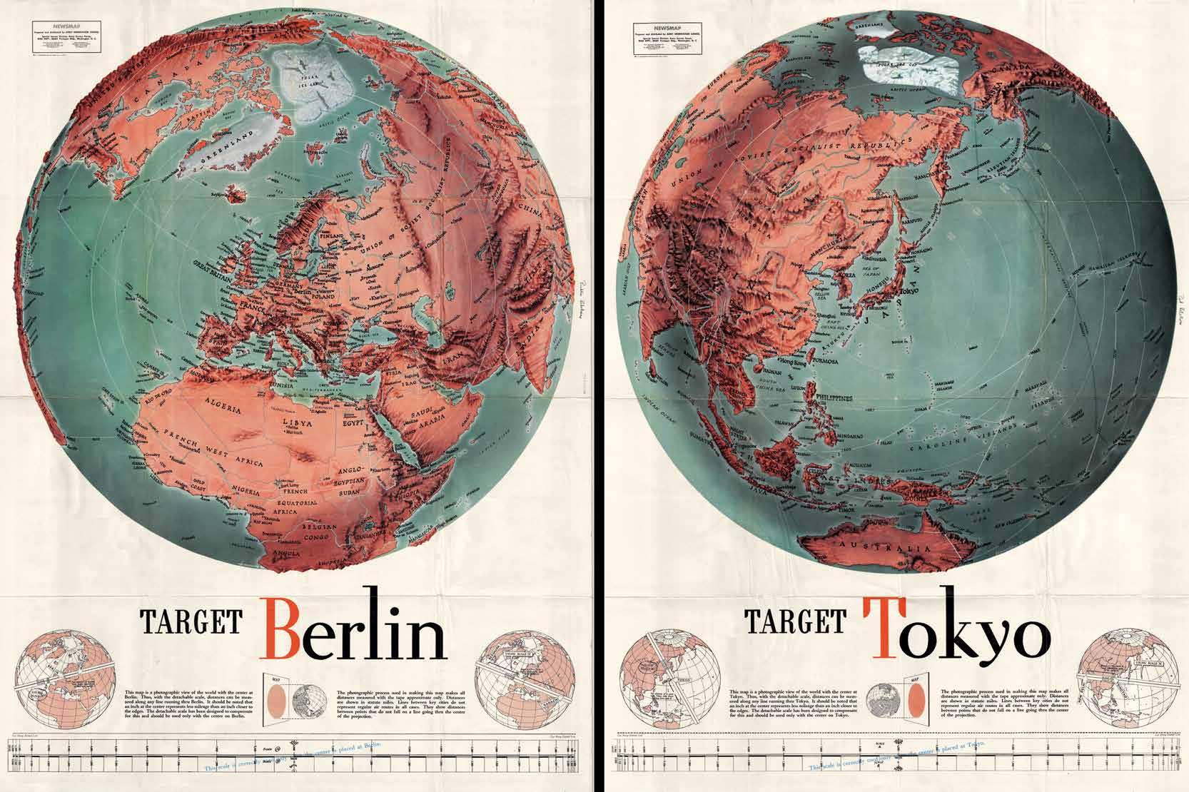
Target Berlin Target Tokyo
These iconic images were drawn by F.E. Manning in 1943, during World War II. They were two of the most dramatic Newsmaps issued by the Army Orientation Course of the Special Service Division Army Service Forces, a propaganda arm of the United States War Department. Newsmaps were distributed to U.S. Troops fighting abroad and, on the reverse, featured optimistic reporting of Allied victories in Russia, Italy, Indonesia, and East Asia.
Target Berlin was issued just days before the first major air raids on Berlin. The series of attacks went on for nearly five months. Much of Berlin was destroyed but it did not appear to weaken the German war machine.