Navigating The
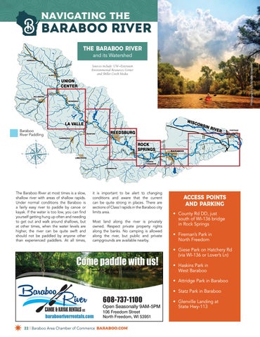
Baraboo River THE BARABOO RIVER Photograph by Michelle Masson
and its Watershed Sources include: UW–Extension Environmental Resources Center and Skillet Creek Media
Baraboo River Paddling
The Baraboo River at most times is a slow, shallow river with areas of shallow rapids. Under normal conditions the Baraboo is a fairly easy river to paddle by canoe or kayak. If the water is too low, you can find yourself getting hung up often and needing to get out and walk around shallows, but at other times, when the water levels are higher, the river can be quite swift and should not be paddled by anyone other than experienced paddlers. At all times,
it is important to be alert to changing conditions and aware that the current can be quite strong in places. There are sections of Class I rapids in the Baraboo city limits area. Most land along the river is privately owned. Respect private property rights along the banks. No camping is allowed along the river, but public and private campgrounds are available nearby.
ACCESS POINTS AND PARKING • County Rd DD, just south of WI-136 bridge in Rock Springs • Fireman’s Park in North Freedom • Giese Park on Hatchery Rd (via WI-136 or Lover’s Ln) • Haskins Park in West Baraboo • Attridge Park in Baraboo • Statz Park in Baraboo • Glenville Landing at State Hwy-113
22 | Baraboo Area Chamber of Commerce Baraboo.com


