8 minute read
Hunting Island


After the Storms
“To describe our growing up in the low country of South Carolina, I would have to take you to the marsh on a spring day, fl ush the great blue heron from its silent occupation, scatter marsh hens as we sink to our knees in mud, open you an oyster with a pocketknife and feed it to you from the shell and say, ‘There. That taste. That’s the taste of my childhood.’” Pat Conroy – Prince of Tides
Advertisement
Story and Photos by John and Lisa Holden
For months I’ve toiled with writing about the eff ects of two hurricane seasons on Hunting Island, one of our most cherished South Carolina barrier islands and state parks. Like many, I suspect, I was initially focused on the horrifi c impacts of Mother Nature on such a beautiful island, a beautiful park and a historic landmark. Visiting the park soon after it reopened this past year was a bit of an emotional event. Words such as shock, despair and grief come to mind. Please understand, I’m sharing thoughts about a state park that endured the wrath of nature – not residential neighborhoods, homes or families impacted by the storms. The sympathy, and often empathy I feel for neighbors nationwide is far deeper when disasters strike. Like many coastal residents, my family dealt with the challenges of Hurricanes Matthew and Irma. My wife and I were also in Houston when Hurricane Harvey struck and we observed fi rst hand neighbors helping neighbors. Remember the “Cajun navy?” We get it.
Barrier islands are normally long, narrow, deposits of sand or sediment that parallel the coastline. As these marvels of nature developed thousands of years ago, they were separated from the mainland by marshes, shallow sounds or lagoons. Many elements infl uenced the development of these islands and are responsible to this day for their changing appearance. Waves and wave action that deposit (or remove) sediment from the ocean-side of the islands are the most infl uential element. Another is off shore currents that tend to move sand from the northern end of our coastal islands, then deposit it further south.
One element we live with daily in our coastal region is the greatest tidal amplitude (over eight feet) in the southeastern U.S. Take a look at a map of the east coast between the Outer Banks of North Carolina and Cape Canaveral, Florida. The curvature of the coast and relatively shallow continental shelf contribute to tidal waters being pushed into a smaller and smaller area. We’re right smack in the middle – an area known as the Carolina Bight north of the Savannah River and the Georgia Bight to the south (at least that’s how we refer to it). High tides tend to build up sediment behind our barrier islands while the ocean side continues to erode.
Another unique feature of our eastern seaboard is the frequency of off shore winds, changing the slope and shape of our beaches, and not always in a positive manner. Hurricane- and nor’easterinduced wave action aff ect our barrier islands the most. Our last two years serve as a prime example.
Last, but certainly not least, a continuous threat to our barrier islands (and elsewhere) is rising sea levels. This is not a statement
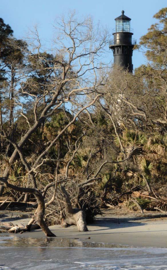
on climate change or global warming. Back in 1889 the Hunting Island Lighthouse (rebuilt after it was destroyed at the beginning of the civil war) was moved 1 ¼ miles inland to its current location, due to erosion. Think about that. Engineers rebuilt the lighthouse post civil war knowing it would some day have to be moved, piece by piece, away from the beach. It was recognized back then that sea levels would rise and slowly erode the island away.
Okay, back to my toiling. It’s been a while since Irma so most debris has been cleared along the drive to Hunting Island. After crossing the Harbor River Bridge (linking St. Helena and Hunting Islands) it’s a bit of a diff erent story. Nature’s wrath is visible as you drive toward the park’s main entrance. Dead and downed trees, trees and bushes striped of vegetation, and standing water are commonplace. Once inside the park, heading to one of the two beach areas the level of destruction is more intense. Why more? You’re closer to it and traveling at a much slower pace.
Images of the force responsible for this destruction come to mind. It is breathtakingly spectacular in its own way. In the midst of broken trunks and limbs, one might see pools of standing water. Granted, the pools are showing signs of drying up but for the longest time the ground was so saturated you dared not venture off the roads or open trails. Even today a few sections of walking trails remain closed due to standing water and the critters that thrive in that wet environment.
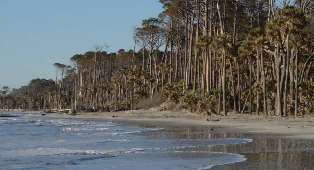
Approaching the beaches, there’s little evidence remaining of sand dunes, which is of particular concern for sea turtle nesting. Loggerheads return to the same general area each year, an area that may stretch over a couple of hundred of miles of coastline. There’s no telling what numbers we’ll see nesting this year due to lost dunes on Hunting Island or our other barrier islands impacted by Matthew and Irma. North and South beach both have what I call tree graveyards – remains of uprooted trees and driftwood that form the ultimate maze for beach walkers to negotiate. Along these stretches of beach are indicators of just how much nature’s violence this past couple years has contributed to Hunting Island’s receding beach front. From a human standpoint, Hunting Island is “migrating” in the wrong direction, toward the tidal fl ats, marshes, lagoons, shrubs and forests tucked in behind remains of the sand dunes. As a point of reference, Hunting Island State Park offi cials suggested the island’s current rate of erosion is 12 to 15 feet per year. Hunting Island is the fastest eroding island along the east coast. That’s four to fi ve yards per year, 80 to 100 yards (a football fi eld) over a 20 year period. This rate of erosion is not new to Hunting Island specifi cally, but it can be a bit unsettling depending on how we process the information. I used a football fi eld as a point of reference – I plan to be around 20 years from now and I’m not looking forward to seeing that much change on my favorite island. Of course, many, many years from now, once the island is gone, what we recognize as our coastline will be unprotected from the eff ects of erosion. The process is never ending.
A secondary eff ect of an eroding barrier island is the impact
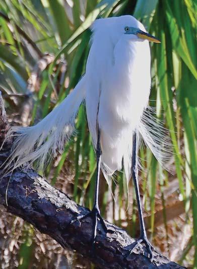
Above: An egret perched on a limb in a lagoon on the lee side of Hunting Island.
This photo: The dunes are completely gone on this stretch of beach, leaving the land and maritime forest behind it unprotected from wave action.

on wildlife and nature. As is certainly the case with Hunting Island, its undeveloped status allows it to serve as a habitat refuge for multiple species of wildlife and vegetation. Although visitors can’t help but be aff ected by the visual carnage throughout the park, that same carnage as observed on beaches, dunes, maritime shrub thickets, and maritime forests, continues to serve as habitat. Wildlife and nature seem to adjust to adverse circumstances much easier than we do as humans. That explains why, when driving through the park, the only noticeable clearing of debris by park staff is on or near roads and paths. Otherwise, it’s up to nature to fi x itself, as it has always done.
That said, some human assistance was needed to repair some parts of the island, such as renourishing parts of the beaches and dunes. Matthew’s nine-foot surge pretty much removed the dunes, allowing Irma to reach further inland with her surge last season. Slowly but surely, things are getting back to normal, but there’s still much to be done. At times the fi xes seem like a chess board – having to do this before that, such as staging sand on one beach in preparation to renourish another. In spite of everything the park staff has going on, to a person they’re thrilled to have people (us) back in their park. Stewardship and service is what they do and they do it well. From my perspective, our Hunting Island staff are the best.
In time, after visiting the park as frequently as I do, after sitting down with park offi cials and hearing some wonderful perspectives, I’ve discarded shock, grief and despair in favor of acceptance. This is how Mother Nature works. This is life in the lowcountry.
At some point Hunting Island, like many of our barrier islands, will most likely vanish from our coastline. Fear not, the island has a long way to go yet. And who knows, maybe we’ll fi gure out a way to reverse the erosion and move the lighthouse back to where it was over 100 years ago. But if the lighthouse is in view, then so is the destruction of the past two hurricane seasons. Take it all in and remember to keep it in perspective. Hunting Island is alive and well. I’m pretty certain Pat Conroy would say so, too.
Above: Sand cleared from the parking area at South Beach after Hurricane Irma.
Right: I'll leave you with a single photo that, in my mind, captures the essence of Hunting Island. The lighthouse. A survivor. A standard bearer. Can you imagine the stories it could tell?