5 minute read
Five Things: Scenic trails around Dane County


Five Things Take a hike
5 scenic trails around Dane County to visit
Advertisement
Story by Emilie Heidemann
As the weather warms, Wisconsin wildflowers again bloom, prairie grasses grow and native birds sing familiar songs. Such are the signs of summer, and you can experience them at many of Dane Countys scenic trails. Upon arrival, can also revel in the therapeutic effects of hiking or walking. Afterall, the activities remain some of the safer ones amid the ongoing COVID-19 pandemic. And whether youre my age of 100, theres something charming and nostalgic about taking an afternoon stroll at any of the five locations Im about to recommend. You could peruse the fairyscape that is the Pheasant Branch Conservancy, located just outside the City of Middleton, or the Cottage Grow entrance to the Glacial Drumlin State Trail. That, or you could take a trek along any stretch of the otherworldly Ice Age Scenic Trail. If you want an unmatchable view of the City of Madison skyline, the Lake Monona Bike Trail is for you. Or, if romantic hikes along a boardwalk suit your fancy, you could visit the Lower Yahara River Trail. No matter what, youll be in for a visual and olfactory treat. Thats particularly true if you remember to stop and smell the flowers once in a while.
The Pheasant Branch Conservancy, according to the Friends of Pheasant Branch Conservancy website, comprises oak savanna and lowland wetland prairies. Photo from the Friends courtesy of the Pheasant Branch Conservancy Facebook page.
Pheasant Branch Conservancy Entrance at 4864 Pheasant Branch Road pheasantbranch.org
The Pheasant Branch Conservancy, according to the Friends of Pheasant Branch Conservancy website, comprises oak savanna and lowland wetland prairies. Its entrance, within City of Middleton limits, is located at 4864 Pheasant Branch Road. With trails for biking, hiking and walking, the 300 acre Dane County Unit of the Conservancy, has spacious uplands with open skies with grasses and mature hardwood stands. The lowlands are traversed by Pheasant Branch Creek, lined with trees and radiant wildflowers during the warmer months. Speaking from experience, walking the trail is like entering an alternate reality. The creek provides millions of gallons of water to Madisons Lake Mendota and the Yahara Chain of Lakes. The corridor can provide a shaded oasis on a warm summer day, the Friends website reads.
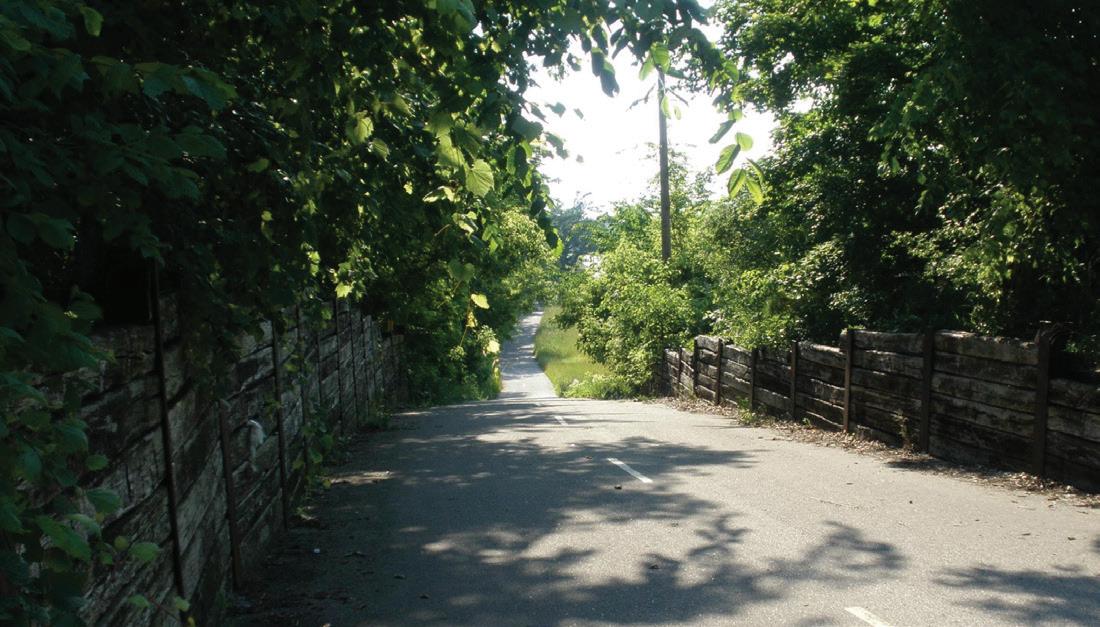
The Glacial Drumlin State Trail parallels State Highway 18 and Interstate 94 between Milwaukee and Madison. Photo courtesy the Glacial Drumlin State Trail Facebook page. Glacial Drumlin State Trail
The Glacial Drumlin State Trail parallels State Highway 18 and Interstate 94 between Milwaukee and Madison. Ive personally visited the trail from the Cottage Grove access point, located at County Highway N going to Junction Road. The 52-mile stretch, going through Dane, Jefferson and Waukesha counties, offers various looks at Wisconsins native prairie and wetlands.
The portion Ive walked is framed by trees, with pockets of human life and suburbia along the way. Around 13 miles have asphalt as its surface, while 39 miles offer crushed stone. Eventually, according to the state Department of Natural Resources website, it may connect to the Capital City and Hank Aaron state trails. The eastern half of the trail begins at the Fox River Sanctuary at College and Prairie Avenues in Waukesha.

The Lake Monona Bike Loop is one of my favorite Madison trails, with an entrance located at Olin Park along John Nolen Drive. Photo by Emilie Heidemann Lake Monona Bike Trail Entrance on Olin Park along John Nolen Drive visitmadison.com
The Lake Monona Bike Loop is one of my favorite Madison trails, with an entrance located at Olin Park along John Nolen Drive. The loop is for more than just biking, of course. And the John Nolen Drive portion offers an amazing view of the City of Madison skyline, particularly if youre walking or hiking along the trail at night. The 13-mile route is paved for easy navigation. With Lake Monona on one side, youll pass the Frank Lloyd Wrightdesigned Monona Terrace Convention Center, Olbrich Botanical Gardens, beachers and some smaller parks. It might be hard to traverse the stretch without stopping at one of Madisons many restaurants and retail establishments depending on COVID-19 restrictions.
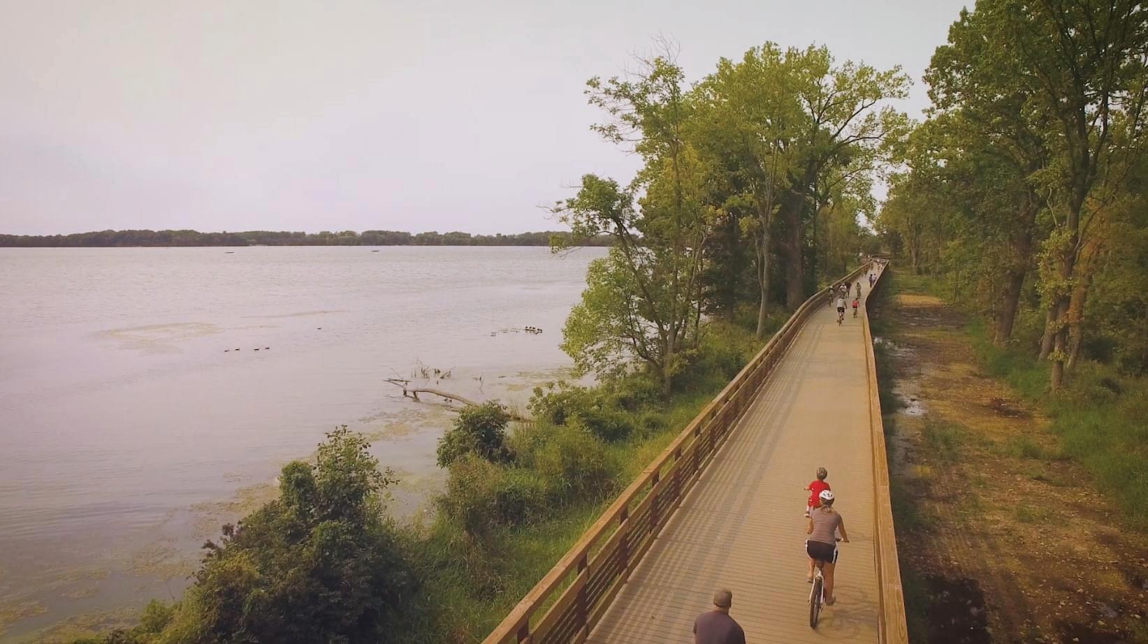
The 2.5 mile Lower Yahara River Trail, according to the Dane County Parks website, includes the longest inland boardwalk bridge constructed solely for non-motorized transportation in North America. Photo courtesy of the Lower Yahara River Trail Facebook page. Unified Newspaper Group April 2021 Young at Heart 7 Lower Yahara River Trail Entrances on Moorland Road, Lake Farm Road parks-lwrd.countyofdane.com
The 2.5 mile Lower Yahara River Trail, according to the Dane County Parks website, includes the longest inland boardwalk bridge constructed solely for non-motorized transportation in North America. Users can access the trail from the east at McDaniel Park in the Village of McFarland, or from the west at either Lewis Nine Springs E-Way parking lot on Moorland Road. Another entrance includes the parking lot on Lake Farm Road across from the Lussier Family Heritage Center. When I checked the trail out for myself, I was with some friends in the dead of winter. I was either overlooking a frozen lake, or surrounded by native Wisconsin trees and shrubs. The views of the water were unbeatable, as the boardwalk, covered with snow, added an air of charm to our excursion.
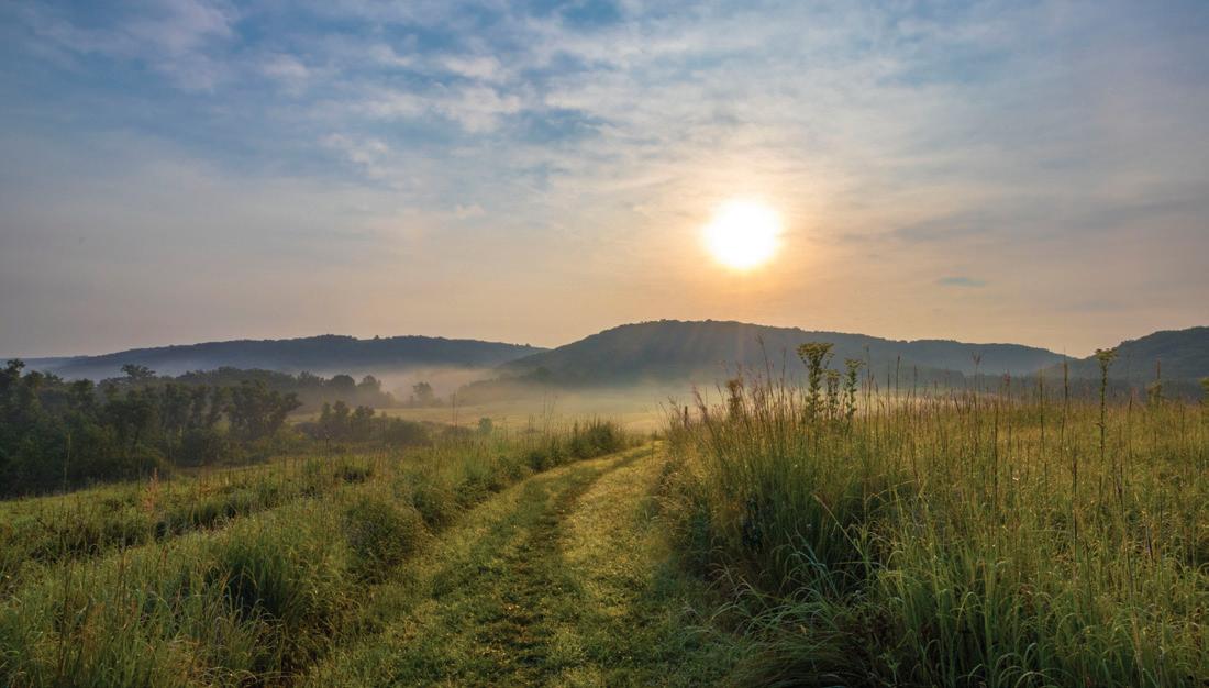
The Ice Age Trail is a recreational hiking and backpacking trail, according to the Dane County Parks website, that starts at St. Croix National Scenic Riverway on the border between Wisconsin and Minnesota. It winds its way for over 1,000 miles across Wisconsin to Potawatomi State Park in Door County. Photo courtesy of the Ice Age Trail Alliance.
Ice Age National Scenic Trail Entrances on St. Croix National Scenic Riverway and Potawatomi State Park danecountyparks.com
While Ive only hiked portions of the Ice Age National Scenic Trail, what Ive observed has been unforgettable. The trail is a recreational hiking and backpacking trail, according to the Dane County Parks website, that starts at St. Croix National Scenic Riverway on the border between Wisconsin and Minnesota. It winds its way for over 1,000 miles across Wisconsin to Potawatomi State Park in Door County. The corridor passes through Dane Countys west side. That includes Lodi Marsh in the Town of Dane to the Brooklyn Wildlife Area in the Town of Montrose. The Ice Age trail traverses the terminal moraine of Dane Countys last glacier, passing through oak savannas, prairies, as well as hickory and maple forests.