6 minute read
AROUND THE MOUNTAINS WE WILL GO

Ideas For Summer Adventuring
by Patti Beardsley
Summer is indeed the time for adventure, for exploring all that we have looked down upon from the summit of many peaks. Throughout our descent (and, truthfully, looking up from below as well), the question lingers in our minds “how can we explore all sides of this mountain?” Day hikes and weekend trips can reveal many wonders, but how about walking all the way around these mountains in one circular adventure?
Ali Gray’s article in the July/August 2023 Mazama Bulletin (pp10-12) Around and Around and Around wonderfully explores circumnavigating Mt. Hood, Mount St. Helens, and the Three Sisters.
This year, we review the other Pacific Northwest Cascade adventures to hike “Around the Mountain” or “Trail and Bushwhack” around the mountain.
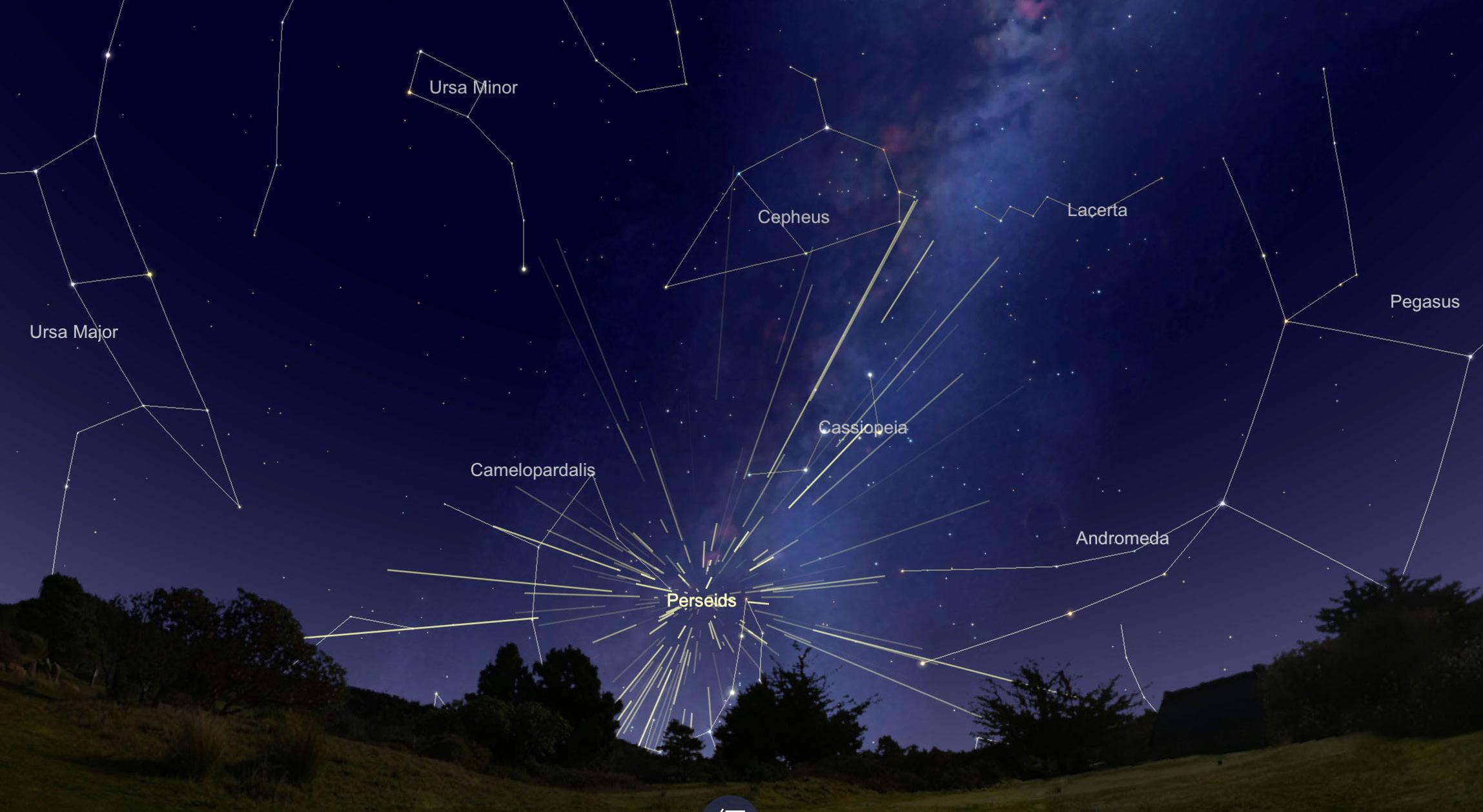
We’ll start with a quick visual of many of the key peaks in the Pacific Northwest, followed by brief introductions to each peak and conclude with links for more information.
Mt. Baker
The northernmost volcanic peak in the Pacific NW (last erupted in 1843), is one of the “Trail and Bushwhack” circumnavigations approximating 75 miles, 22,000 feet elevation gain (and loss), and multiple scenic ridges and stream crossings. Research and preparation are the key for this adventure.
Glacier Peak Circuit
The Glacier Peak Circuit (loop trail from White River Trailhead) is one of the routes around this peak and reported to be 96 miles, 20,000 feet in ups and down, with steep ridges and stream crossings ( www.darnoldhiking.com/glacier-peak- wilderness.html). Geology indicates an explosive eruption at the end of the last ice age ejecting more than five times as much tephra as the May 18, 1980 Mount St. Helens eruption. Lucky are those who are ready to go on the Mazama outing’s 83 mile route around Glacier Peak from August 17–23.
Mt. Rainier
Mt. Rainier’s Wonderland Trail is a truly wonderful and quintessential “Around the Mountain” experience. Permits are required but early February application for the lottery by each person in your party dramatically increases your chances of being able to book a group time of your choice. This 93+ mile trail with over 20,000 feet elevation is an endless delight of mountain views, creek crossings, glacier sightings, meadows, and critters. We were fortunate to have a family member meet us twice (where the trail passed through Mowich* and White River campgrounds) to provide home cooked food, beverages and resupplies for the next three days. Again, advanced research helps ensure that you are planning appropriate mileage every day.

Mount St. Helens
The Loowit Trail provides first hand experiences with recent volcanic activity and the phenomenal regrowth. In Ali’s article Around and Around and Around, she describes the 30+ mile (6,500 feet) hike as challenging and “incredible, offering upclose views of the otherworldly landscape.”
Mt. Adams
Mt. Adams is one of the greater “Trail and Bushwhack” opportunities noted to be over 30 miles and crossing through the Yakama Nation which may require permits. Views of peaks and ranges are plentiful all the way around the peak, as are views and experiences of recent fire events. There is no specific trail defined all the way around, so research is necessary every year.
Mt. Hood
Mt. Hood’s Timberline Trail (42 miles, 10,000 feet elevation gain) is a staple for adventurers of all ages (Girls Scouts to oldsters included) and is another great hike to share with non-hiking families who are inclined to resupply you at any of the several back road crossings. Again,
Ali’s 2023 article provides a wonderfully descriptive account.
Mt. Jefferson
Mt. Jefferson circumnavigation is another “Trail and Bushwhack” adventure. There are a variety of routes on the west side from north to south (or vice versa) all requiring permits during the June–October high season, but the east side crosses the Warm Springs Reservation which also requires permits for camping and through hikers. There is also a more rugged but shorter 30 mile high route that includes a lot of trail finding.
Three Sisters Wilderness
The Three Sisters Wilderness provides endless possibilities including a “30 miles in 30 hours” Elk Lake to McKenzie Pass Pacific Crest Trail (PCT) hike, and the Three Sisters Marathon (Pole Creek Loop or Pole Creek to Devil’s Lake or Obsidian Trailhead to Devil’s Lake). These routes provide more opportunities to involve friends and family in a car shuttle and celebration of success. Again, Ali’s Around and Around and Around has a wonderful account of the 57-mile circumnavigation of the Three Sisters PLUS Broken Top Diamond Peak
Diamond Peak has several Around the Mountain options (20–30 miles) all of which include side trails to lakes or to the summit, and all of which include time on the PCT. Permits are required during the June–October high season. It’s truly magical to be atop Diamond Peak surrounded by migrating Monarch Butterflies in late summer.
Crater Lake
Crater Lake is best known for the road around the rim, but there is a sweet 23 mile hiking trail, the Lightning Trail/PCT Loop, on the west side (permits required, no dogs). And, if you’re so inclined, it is a challenging yet spectacular 33 mile bike ride with the potential reward of sunset on the lodge deck at the end of the day (ride clockwise to maximize views and pull offs). And, if you can start early (5:30 a.m.) on continued on next page Above: Mt. Rainier and Emmons Glacier from Sunrise on the northeast side of the mountain.
Mt. Shasta
Mt. Shasta, although not technically in the Pacific Northwest, draws hikers and climbers from around the globe because of its dozens of trails and ascent routes. However, this is truly a “Trail and Bushwack” adventure and an opportunity for future development of a true “Around the Mountain Trail” for those who are inclined to tie the existing trails together.
In addition to these explorations around our favorite peaks, there are unlimited other adventures in the West from the North Cascades to the Olympics to areas south of Mt. Shasta. What are your favorite loop trips? And, what are your best reference sites? Please build on this knowledge base by sending your stories to stories@mazamas.org and we’ll include them in future Mazama Bulletins
In the meantime, here are some resources to plan your adventures:
Pacific Crest Trail Association, where are permits required:
www.pcta.org/discover-the-trail/ permits/local-permits/
The Circumnavigation Project
□ www.mountbakerexperience.com/ stories/360-degrees,874?
■ Circumnavigation of Mt. Baker
□ www.mountbakerexperience.com/ stories/the-miracle-route-an-offtrail-circumnavigation-of-mtbaker,750
■ Glacier Peak Trails
□ www.nps.gov/glac/planyourvisit/ upload/Wilderness-CampgroundMap-2024_accessible.pdf
■ Mt. Adams
□ www.reddit.com/r/Ultralight/ comments/pjbptf/highline_loop_ mt_adams_washington_94_52021/
■ Mt. Jefferson east side accessibility
□ www.peakvisor.com/park/warmsprings-indian-reservation.html
■ Mt. Jefferson High Route
□ www.cascadeclimbers.com/forum/ topic/107551-mt-jefferson-highloop/
□ www.medium.com/@jrit/mtjefferson-high-loop-9c441b1ec586

* Washington SR165 to Carbon River and Fairfax Bridge is currently closed, with no access to Carbon River or Mowich Lake.