CHAPTER 15: Site Allocations – Gypsy and Traveller
GT1, Land South of Harrow Road
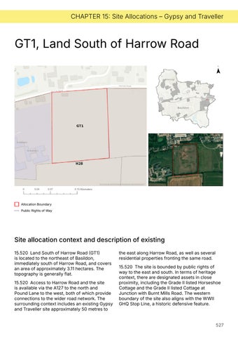
Allocation Boundary Public Rights of Way
Site allocation context and description of existing 15.520 Land South of Harrow Road (GT1) is located to the northeast of Basildon, immediately south of Harrow Road, and covers an area of approximately 3.11 hectares. The topography is generally flat. 15.520 Access to Harrow Road and the site is available via the A127 to the north and Pound Lane to the west, both of which provide connections to the wider road network. The surrounding context includes an existing Gypsy and Traveller site approximately 50 metres to
the east along Harrow Road, as well as several residential properties fronting the same road. 15.520 The site is bounded by public rights of way to the east and south. In terms of heritage context, there are designated assets in close proximity, including the Grade II listed Horseshoe Cottage and the Grade II listed Cottage at Junction with Burnt Mills Road. The western boundary of the site also aligns with the WWII GHQ Stop Line, a historic defensive feature.
527